Um - what you doing with that beer keg? Asking for a friend.
Tropical two-fer
547,205 Views |
3418 Replies |
Last: 3 yr ago by V8Aggie
I still don't have power in Port Neches. This was worse for us than Laura. I haven't seen this much damage in Mid County since Rita.
Just got power back at my house in Sulphur yesterday afternoon. No new damage, so we are very thankful for that.
Don't believe any will be a threat to us, but...


lolwut
Remind me what happens when a tropical storm runs into a blue norther?
what happens?
The L is for Louisiana
Hello Darkness My Old Friend...


AgLiving06 said:
what happens?
Sharknado. We are screwed.
Almost exactly Delta's path other than the shift east at the end
I look forward to this joke being driven into the ground over and over and over againAlex Bregman said:
The L is for Louisiana
Fitch said:
Remind me what happens when a tropical storm runs into a blue norther?

By the way, The Perfect Storm occurred around Halloween 1991.
Need a blue cart update.
I bet it's still blue.Cromagnum said:
Need a blue cart update.
That thing is hauling ass, it's going from Louisiana to Virginia faster than Harvey crossed my backyard.
I don't know. The bleach variation joke hasn't even run its course yet.BowSowy said:I look forward to this joke being driven into the ground over and over and over againAlex Bregman said:
The L is for Louisiana
Alex Bregman said:
The L is for Louisiana
If its an H its for Houston, or Houma.
Well just got Zeta'd. Woke up to no power on Western NC.
What do you boys want for breakfast BBQ ?.....OK Chili.
No power at my office in Georgia so I came up near you to check on my place. All good. Last storm was Irma and it gave me a good kick in the ass.MAROON said:
Well just got Zeta'd. Woke up to no power on Western NC.
I mean, why not? It is 2020.


The story isn't that [DeSantis] "couldn't win" the primary. The story is that an overwhelming majority of our population is heinously stupid. 50% of them vote for communists. 75% of the remaining 50% vote for Trump, who cant win. When the majority of the opposition party insists on voting for an opposition candidate who can't win, you get exactly the government you deserve. - Well Endowed Ag
Saw center point trucks headed East this morning to help.
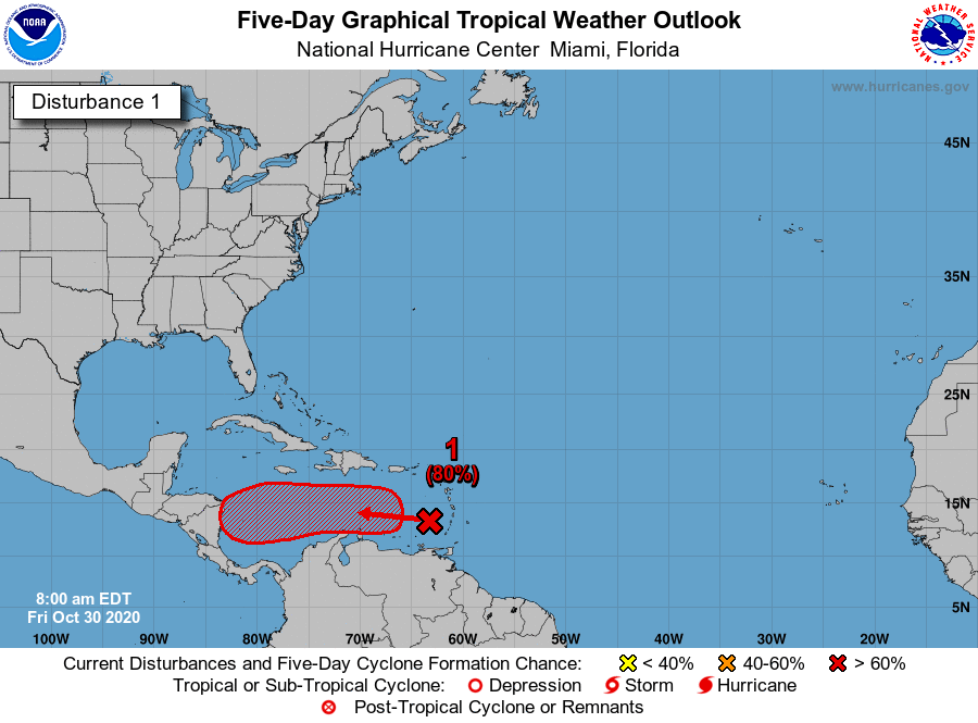
Projected path


Mother nature pulled a Rick James ****ing up Louisiana's couch with some muddy boots.
No..it has to loop back into the gulf a couple times to regain cat 4 strength before hitting Louisiana over and over.
SPF250 said:No power at my office in Georgia so I came up near you to check on my place. All good. Last storm was Irma and it gave me a good kick in the ass.MAROON said:
Well just got Zeta'd. Woke up to no power on Western NC.
Got power back at 4:00. All around fun day though. Drank coffee and checked emails in town. Drank Irish whiskey at the old Edwards inn, then cooked steaks outside tonight as the cold front made it here
What do you boys want for breakfast BBQ ?.....OK Chili.

Latest from SCW.Quote:
If it gets a name, it will be called Eta, and 2020 would officially tie 2005 for the most storms on record in the Atlantic basin. As much as it pains me to write this, Eta is a storm that should probably be watched from Louisiana to Florida. It's likely to percolate off the coast of Central America much of next week before perhaps being ushered north next weekend by our next weather maker over the Plains & Texas. How exactly that plays out is TBD. This is highly unlikely to come to Texas, but there a number of model solutions that bring it into the eastern Gulf or off the Florida coast. So, yet again, another one for our neighbors to the east to watch. We'll update you on Monday.
I'm hoping we can get to Psi for those sweet Gangnam Style memes
Nicaragua getting hammered, winds currently between 140 to 150mph
Quote:
During the day Tuesday, Eta is forecast to produce catastrophic wind gusts of over 100 mph, destructive storm surge up to 14-21 feet, and rainfall amounts up to 35 inches. These impacts will lead to life-threatening conditions for anyone in the path.
Due to Eta's slow forward motion, the 2-3 feet of expected rainfall is particularly concerning.
The story isn't that [DeSantis] "couldn't win" the primary. The story is that an overwhelming majority of our population is heinously stupid. 50% of them vote for communists. 75% of the remaining 50% vote for Trump, who cant win. When the majority of the opposition party insists on voting for an opposition candidate who can't win, you get exactly the government you deserve. - Well Endowed Ag
There will be some serious mudslides with all of that rain. T&P for that area.
Looks like it is now headed back into the Caribbean aimed at Cuba. Should hit there (Sunday) and then turn into the Gulf aimed at New Orleans. Get almost to New Orleans then turn toward Mobile.


Good lord.


Featured Stories
See All
9:07
10h ago
3.4k
16:07
13h ago
2.4k
Disparity from deep dooms No. 7 Texas A&M against No. 6 Vols, 77-69
by Olin Buchanan
4:43
13h ago
669
Game Highlights: No. 6 Tennessee 77, No. 7 Texas A&M 69
by Matthew Dawson
13:35
1d ago
4.9k
CatD11Ag
No. 6 Aggies sweep doubleheader from No. 8 Seminoles in Tallahassee
in Billy Liucci's TexAgs Premium
3


