Metroplex
Sponsored by

***Metroplex Winter 2024-2025 Thread***

87,429 Views | 900 Replies | Last: 8 hrs ago by Danny Vermin
planoaggie123
How long do you want to ignore this user?
AG
Obviously this pending level of cold is not awesome but its more manageable with no snow.

IF we lose power, it is much easier (though still not fun) to shut down pool equipment etc when you are not battling snow / ice on and or even just around the equipment...
riverrataggie
How long do you want to ignore this user?
AG
Yeah. Looks to be very similar to this last go around in terms of air temp. Just no precipitation this go around.

What will help a lot is sun. 28-30 and sunny is a big difference than 34 and rainy.
wangus12
How long do you want to ignore this user?
AG
I don't have any problem with 28-30 and sun. That's not to bad and really doesn't put the pipes at risk or anything.
Kate Beckett
How long do you want to ignore this user?
AG
No precip makes me happy.
FTAG 2000
How long do you want to ignore this user?
AG
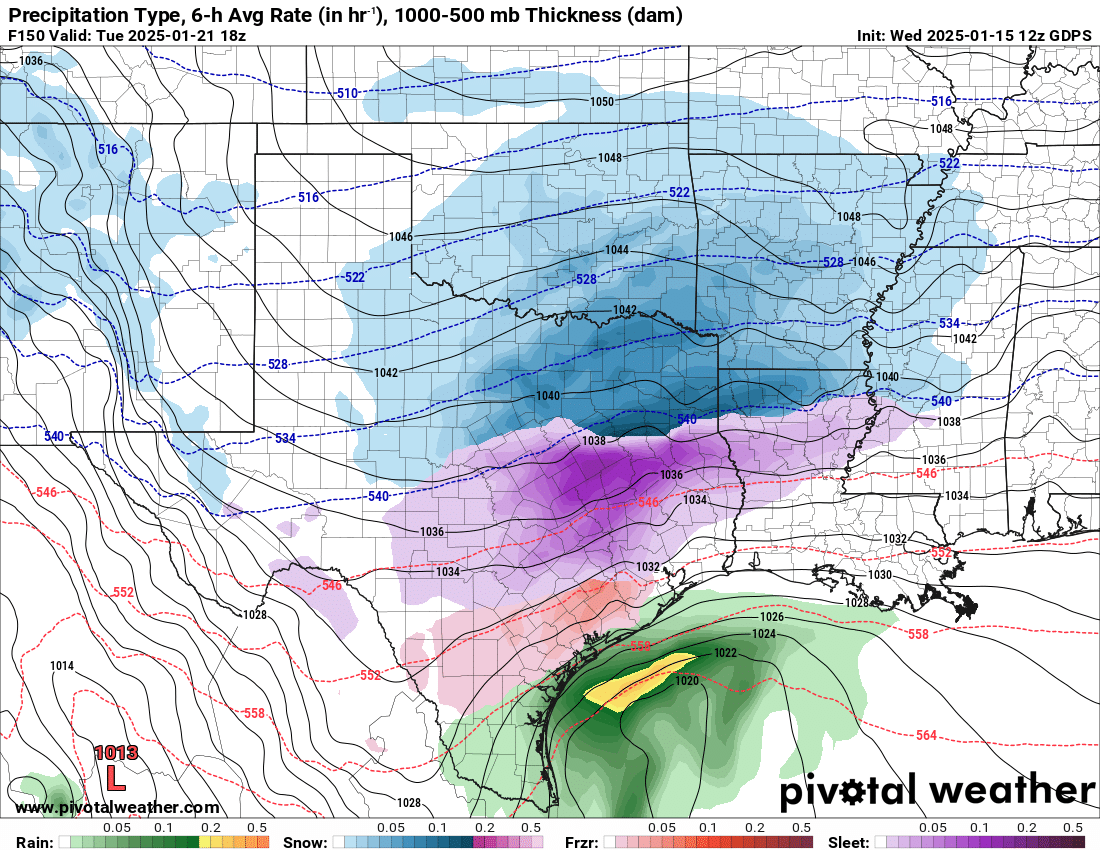
Noon model runs today are pointing to snow and ice on Tuesday. All the way to the Gulf Coast.

It's the first time the models have come around to this, so we need to see more runs for consistency in the data, etc. but did want to share that.

beatlesphan
How long do you want to ignore this user?
AG
Given how far north the prior storm's bullseye went...maybe the runs starting with target in Houston will end up in DFW ha
No material on this site is intended to be a substitute for professional medical advice, diagnosis or treatment. See full Medical Disclaimer.
FTAG 2000
How long do you want to ignore this user?
AG
Yeah, I don't expect those to hold with precip that far south.
wangus12
How long do you want to ignore this user?
AG
Ugh traveling next week is gonna be a headache
ChoppinDs40
How long do you want to ignore this user?
AG
wangus12 said:

Ugh traveling next week is gonna be a headache
yup. I've got a flight early Wednesday morning.
wangus12
How long do you want to ignore this user?
AG
Same. Have to be in Miami by Thursday morning
FincAg
How long do you want to ignore this user?
AG
Evan is still spicy about online forecasters.
Decay
How long do you want to ignore this user?
AG
Monkey look at colors
Monkey see blue
Monkey forecast snow
Monkey predict weather
FTAG 2000
How long do you want to ignore this user?
AG
FincAg said:

Evan is still spicy about online forecasters.


The amount of butt hurt this guy shows in his posts and weather segments is pretty sad.

The National Weather Service is putting out the same thing as those wannabe social media meteorologists but you don't see him saying anything about the pros.
double aught
How long do you want to ignore this user?
AG
Weathermen are almost as sensitive as realtors when it comes to questioning their profession.
planoaggie123
How long do you want to ignore this user?
AG
double aught said:

Weathermen are almost as sensitive as realtors when it comes to questioning their profession.
PrestigeWorldwideAg12
How long do you want to ignore this user?
Supposed to fly to Sacramento on Monday and fly back from San Jose on Thursday... Fingers crossed this doesn't turn into a cluster
FTAG 2000
How long do you want to ignore this user?
AG
double aught said:

Weathermen are almost as sensitive as realtors when it comes to questioning their profession.
Cody's not going to like that post one bit.
PatAg
How long do you want to ignore this user?
AG
double aught said:

Weathermen are almost as sensitive as realtors when it comes to questioning their profession.
Its also funny seeing the online and forum prognistactors get real touchy when its pointed out that they are frequently very wrong, and they dont even have a horde of online trolls tweeting at them every time.
The cycle is "overhype some obscure 'model' that is still too far out", then when it inevitably changes in the lead up youjust pretend you never overhyped in the first place. Then when the day comes and its completely incorrect, you just move on to the next "event"
FTAG 2000
How long do you want to ignore this user?
AG
Latest model runs are showing:

- First front of cold arriving this Friday after dark
- Cold and colder all weekend, with below freezing both nights
- Monday high in the low 20s
- Tuesday high in the teens
- Precip Tuesday (would be snow for north Texas, given temps)
- Cold but into mid 30s for highs Wednesday
- Another front dropping temps and more wintry precip in the Thursday to Friday time frame

For you visual folks:

Tom Cardy
How long do you want to ignore this user?
AG
the canadian sure does love a cold bias
wangus12
How long do you want to ignore this user?
AG
I saw something that said the Canadian was showing below 0 temps in Houston at one point
Tom Cardy
How long do you want to ignore this user?
AG
canadian is the only ensemble group currently showing mean temps in the teens, others are mid 20s for DFW.

lots can change before then, and things may trend a little colder than currently shown
FTAG 2000
How long do you want to ignore this user?
AG
The models traditionally haven't done well with the siberian air that comes down out of Canada.

I don't think temps will be that extreme south, though it's going to be cold for them as well. I do think we'll be in the teens next week for one or more days.
riverrataggie
How long do you want to ignore this user?
AG
Are you saying teens as in lows, highs, median?
HomeFinderCody
How long do you want to ignore this user?
Sponsor
AG
FTAG 2000 said:

double aught said:

Weathermen are almost as sensitive as realtors when it comes to questioning their profession.
Cody's not going to like that post one bit.
I'm shocked.
I'm hurt.
I'm going to need a minute to recover.

How DARE you compare me to a weatherman!!
Sponsor Message: Need real estate help in North Texas? Click Here to Save $500
FTAG 2000
How long do you want to ignore this user?
AG
riverrataggie said:

Are you saying teens as in lows, highs, median?

Models sure are pointing to us being in the teens for a high on Tuesday.

Lows in the teens to 20s Sunday - Tuesday night.
riverrataggie
How long do you want to ignore this user?
AG
That's a bold prediction. Polar vortex isn't moving out of Canada really. This would be worse than 2021 with that statement.
ftworthag02
How long do you want to ignore this user?
AG
NWS: Highs 36 for Monday and 32 for Tuesday
Kate Beckett
How long do you want to ignore this user?
AG
Just happy they took out the flurries on Saturday night/Sunday morning.
FTAG 2000
How long do you want to ignore this user?
AG
Overnight models shifted the extreme cold east of Texas.

Now showing 30s for highs, upper teens to 20s for lows for Sunday-Tuesday. No snow, sleet, or ice for Texas (well, maybe some panhandle magic, but otherwise dry).

Slight warmup Wednesday, then another system with cold and possible precip Thurs-Fri.

wangus12
How long do you want to ignore this user?
AG
That's what I want to see lol. Give me those storm2k tears
planoaggie123
How long do you want to ignore this user?
AG
I know it's still early but that sounds good to me.

I will take some low 20s as long as we also get an hour or two of above freezing each day. Also have no desire for any winter precip. I know it's possible but I will gladly take cold and dry.
FTAG 2000
How long do you want to ignore this user?
AG
Of course, after I post, the National weather service says:

An arctic front will surge south through all of North and Central
Texas Friday night, bringing much colder weather for the holiday
weekend into next week. Confidence is still high that dangerously
cold weather will be in place for multiple days beginning Saturday
night, with lows in the teens and 20s along with wind chills in
the single digits and teens. A Cold Weather Advisory will likely
be needed at some point starting sometime this weekend. It is
possible that temperatures do not climb above freezing in some
locations for a few days, particularly Monday and Tuesday
following a reinforcing shot of arctic air. On Monday for
instance, areas along and north of Highway 380 and along/west of
I-35 have the highest probability of max temperature at or below
32 (around 70-80%). Either way, high temperatures will remain in
the 30s areawide Sunday through Tuesday, which even for January
is 20 degrees below normal.

As important as all of that is, the more frequently asked
question focuses on winter precipitation probabilities and the
potential for travel impacts. Anytime North and Central Texas
becomes enveloped in an airmass this cold, even modest amounts of
available moisture can produce enough light precipitation to cause
impacts. The upper level feature of interest at this juncture
continues to be a positive-tilt shortwave, which is progged to
drop southeast around the southwest flank of a longwave trough
entrenched over the center of the CONUS at the start of next week.
Model guidance has been struggling with consistency regarding the
strength of the isentropic lift out ahead of the shortwave and
amount of available moisture. If the ascent is strong enough, the
upper level system typically can find enough moisture to produce
precip, and consequently higher moisture content can often
overcome weak lift. Due to a lack of any significant changes in
guidance since yesterday, will stick somewhat close to persistence
for this forecast package, indicating a chance of light snow along
with minor to no accumulations.

One thing to note is that last night`s National Blended Model has
increased POPs compared to previous runs, perhaps attributed to
slightly more aggressive (with QPF) ECMWF members. Will therefore
increase POPs slightly, and extend the slight chance POPs farther
north to near the Red River, both based on the latest NBM numbers.
That being said, due to the presence of such a dry airmass,
accumulations will be kept in the "minor to none" category for
now. There continues to be a lot of uncertainty regarding QPF,
however, so the forecast could still shift to higher accumulations
(or none) depending on how the upstream shortwave evolves. Much
more will become known over the weekend when better resolution
model guidance comes into play. Whatever the case, temperatures
should finally start to modify during the latter half of next week
as the longwave trough weakens and shifts east. Temperatures may
even approach near-normal values by Thursday or Friday of next
week.

30
PatAg
How long do you want to ignore this user?
AG
What is that formatting, lol
FTAG 2000
How long do you want to ignore this user?
AG
PatAg said:

What is that formatting, lol

Copy and paste on mobile from the NWS site.

 
×
subscribe Verify your student status
See Subscription Benefits
Trial only available to users who have never subscribed or participated in a previous trial.