
What street in Elm Grove did you live on?
Kingwood flooding doesn't pass the smell test
78,374 Views |
567 Replies |
Last: 5 yr ago by notheranymore
Ferris Wheel Allstar

Joined:
Mar 19, 2006
Posts:
25,048
How long do you want to ignore this user?
AG
Beaver GlenFerris Wheel Allstar said:
What street in Elm Grove did you live on?
King's Harbor with the new and improved lower Lake Houston level.


So Forest Cove residents can't get permits to rebuild and haven't been bought out, though they probably will.
In the meantime, they say they are being fined by the COH for not having their property maintained.
Guitarsoup said:
King's Harbor with the new and improved lower Lake Houston level.
Look at all that sand that can be mined!!!
LOL - i cant wait for the mosquitos to come out! I am unsure if the powers at be understand that 2.5ft of water will equate to a TON of exposed river/lake.
Here is well reasoned article that takes into account several key items (several discussed on this board.)
https://www.chron.com/neighborhood/kingwood/news/article/Officials-take-proactive-step-to-lower-Lake-12786210.php
Here is well reasoned article that takes into account several key items (several discussed on this board.)
https://www.chron.com/neighborhood/kingwood/news/article/Officials-take-proactive-step-to-lower-Lake-12786210.php
Would be interested to see a pic from 2011for comparison.Guitarsoup said:
King's Harbor with the new and improved lower Lake Houston level.
94chem said:Would be interested to see a pic from 2011for comparison.Guitarsoup said:
King's Harbor with the new and improved lower Lake Houston level.

Thanks. I remember barely even needing the bridge to drive to Atascocita. Found a clamshell the size of a small dinner plate walking out there.
The West Fork of the San Jacinto River at Highway 59 is "rising rapidly" and will exceed its banks Thursday morning, according to meteorologist Jeff Lindner of the Harris County Flood Control District.
It's supposed to crest tonight at 49.9'. According to the warning I saw, homes start flooding at 50.3'
You probably can't definitely prove lowering the lake helped, and you probably can't definitively prove it didn't. All I know is that intuitively it seems that it must help if the river is going to crest that high. Thank you city officials.
If it's back in to homes at 50.3, then this was a good call. I presume that might be the Forest Cove level.NomadicAggie said:
The West Fork of the San Jacinto River at Highway 59 is "rising rapidly" and will exceed its banks Thursday morning, according to meteorologist Jeff Lindner of the Harris County Flood Control District.
It's supposed to crest tonight at 49.9'. According to the warning I saw, homes start flooding at 50.3'
You probably can't definitely prove lowering the lake helped, and you probably can't definitively prove it didn't. All I know is that intuitively it seems that it must help if the river is going to crest that high. Thank you city officials.
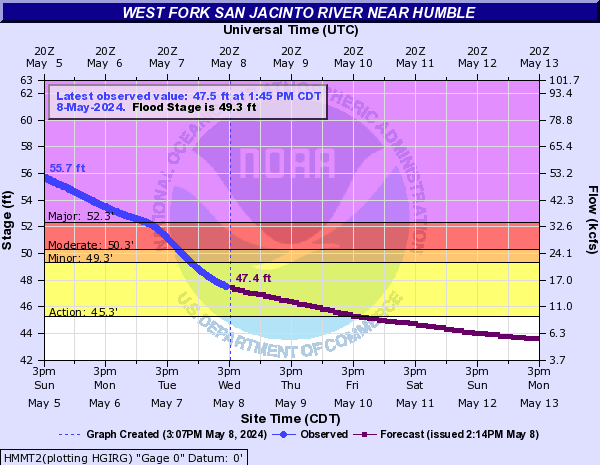
Any home that floods at 50.3 should not be inhabited, river hits that level way too frequently.
I'm sure this does wonders for the bridge construction.
I'm sure this does wonders for the bridge construction.
redag06 said:
Any home that floods at 50.3 should not be inhabited, river hits that level way too frequently.
I'm sure this does wonders for the bridge construction.
EDIT - nevermind, got my years mixed up. 2016 had 57' and 62', 2015 had 50' and 54'
Here's the weather.gov description of what the levels mean (if I would have bothered to scroll down)
Quote:
55.2
Major lowland flooding continues with up to 6 inches of water is over the 800 block Hamblen Road adjacent to the Kingwood Cove Country Club Golf Course with many homes in the Bellau Woods and Treasure Cove subdivision are flooded.
54.4
Major lowland flooding continues with homes along Riverview Drive in River Ridge subdivision upstream of the gauge begin to flood.
53.3
Major lowland flooding continues with water is in homes on Lake Lane West and Southshore Drive in the Bellau Woods subdivision and Homes in the Treasure Cove subdivision and along Aqua Vista Drive begin flooding.
52.3
Major lowland flooding begins as homes on Lake Lane West and Southshore Drive in the Belleau Woods subdivision begin flooding. Roads into the Treasure Cove subdivision are inundated and homes along Aqua Vista Drive threatened. Water is in many homes on Lake Point Drive in the Northshore subdivision.
51.5
Moderate lowland flooding continues with up to one foot of water is over the road at the intersection of Bellau Wodd and Riviera and many homes in the Northshore subdivision are flooded.
50.3
Moderate lowland flooding begins as homes on Lake Point Drive in the Northshore subdivision begin flooding and roads in the Bellaeu Woods subdivision are inundated.
49.3
49.5 feet MSL...Minor lowland flooding begins in the vicinity of the gage. North side turnaround at US 59 begins to flood. Low points on Thelma Road, Aqua Vista Drive, and Riverview Drive begin to flood.
So last night if you take roughly an average of 3" of rain across the just western side of the lake houston watershed, which is probably an underestimate because parts of cypress creek got upwards of 5", the West Fork alone pushed in around 205000+ acre ft of water towards Lake Houston this morning. That is more than 10 times the amount of water that was drained out of the Lake and this was not even Harvey.
Also, if you read the Chronicle article above, it alludes to the real reason of doing it was to help clean out the silt from the lake. It wasn't about adding flood capacity to the lake, really.
Also, if you read the Chronicle article above, it alludes to the real reason of doing it was to help clean out the silt from the lake. It wasn't about adding flood capacity to the lake, really.
Yeah, they can't drain it fast enough to catch up, so a pre-release will only do any good for the really low lying stuff at the margins (some of whom were probably helped this time, though I would hope they didn't move back in after Harvey, supposing their houses are still there). Would be interesting to see what larger gates would do, but I am thinking that there's no magic bullet here.FHKChE07 said:
So last night if you take roughly an average of 3" of rain across the just western side of the lake houston watershed, which is probably an underestimate because parts of cypress creek got upwards of 5", the West Fork alone pushed in around 205000+ acre ft of water towards Lake Houston this morning. That is more than 10 times the amount of water that was drained out of the Lake and this was not even Harvey.
Also, if you read the Chronicle article above, it alludes to the real reason of doing it was to help clean out the silt from the lake. It wasn't about adding flood capacity to the lake, really.
Trust me I know the levels of flooding at the San jac. I use the turn around and hamblen that is the first to flood.
I had looked at that gauge website starting back in 2015, but never actually saw the description of what each level meant until just now. Add that to the data tables that they have and people can get a pretty good idea of how often it gets up to certain levels. Seems like folks should expect it to get up this high at least every other year.redag06 said:
Trust me I know the levels of flooding at the San jac. I use the turn around and hamblen that is the first to flood.
Northshore subdivision on the San Jac is taking on water.
I've never driven through the Treasure Cove Subdivision. Apparently it's on the west side of 69. I checked on the Elevation Finder, and it's mostly in the low 50's. Being so close to the River, I guess they will pretty much see whatever the river sees. Back to the east where the homes were flooded by lake back-up, as best as I can tell, 60' was the magic cut-off point. That is, homes under 60' flooded, corresponding to a gauge depth at the bridge of ~70'. Harvey must have put almost 20' into those homes in Treasure Cove. Think I'll try to drive through there tomorrow - have to go to Lowe's anyway to get some stuff for repairing my home.chimpanzee said:I had looked at that gauge website starting back in 2015, but never actually saw the description of what each level meant until just now. Add that to the data tables that they have and people can get a pretty good idea of how often it gets up to certain levels. Seems like folks should expect it to get up this high at least every other year.redag06 said:
Trust me I know the levels of flooding at the San jac. I use the turn around and hamblen that is the first to flood.
I believe most residents left in north shore neighborhood are all on stilts.
I think all of treasure trove was bought out after 94. Have neighbors who all went to khs in 94 and they said they were friends with a family who was the last hold out in treasure trove and the lot then became a party spot.
I think all of treasure trove was bought out after 94. Have neighbors who all went to khs in 94 and they said they were friends with a family who was the last hold out in treasure trove and the lot then became a party spot.
Had to look up where that was. Looks like the elevations over there are about 54'. For kicks, the sand bar at River Grove Park shows about 45 - 49'. In retrospect, it's odd that so many of the low-lying areas in Forest Cove were the first homes in Kingwood, before there even was a Kingwood. Apparently they didn't think a lot about flooding in the late 1960's either.BigPuma said:
Northshore subdivision on the San Jac is taking on water.
On the south shore across the water, which I presume is the Belleau Woods area, the elevations are 49', or even slightly lower. I don't think I've ever been over there. The map shows lots, but I bet they were all bought out after '94, or up on 10' stilts.
Here's the tool I use; kind of cool:
Elevation Finder
73.5'
78.4'
Yeah, that's pretty much the norm for Bear Branch, Hunter's Ridge, Elm Grove. You're only in water danger from storm drains, bayous, fridges, washers, water heaters, and giant holes poked in the roof by trees in the middle of a storm.Guitarsoup said:
73.5'
Why must we be so dependent on liquids...
The boat launch on West Lake Houston Drive during the rescue operations was in the Wendy's parking lot. The N side of that lot is 61', and the S side is 59'. Looks like the 60' estimate is accurate, almost to the inch, at least with respect to those who were flooded by Lake Houston.
67.3 at my house in King's Point.
Looks like the top of the LH dam is right at that same 60' elevation. How close did it come to going over the top of the road that is on the East side of the top of the dam.
I live very close to the damn. Using that elevation tool and a marker in my backyard. It looks like the water came up to around 52ft +/- 1ft
Sounds about right. I heard that the water was 8' over the spillway, which would be ~50'. I was talking about disrupted equilibrium a few posts back. The lake itself basically had a "momentary" delta of 10' in elevation from the spillway to Kingwood town center. Most people would refer to that as a river.evestor1 said:
I live very close to the damn. Using that elevation tool and a marker in my backyard. It looks like the water came up to around 52ft +/- 1ft
I've driven over the 59 bridge several times since yesterday. You can tell the water level is going up. A sandbar that was visible yesterday is submerged today.
Water was up to the railing on the pier at River Grove Park yesterday. Crazy. I was headed over there to hang out, but decided against drowning. That new sandbar must have backed things up like a toilet with too much paper.
67.1' Water had filled our culdesac and was creeping above my curb. Then the sun came out and the waters started going down.
I guess they ran out of sand pits on the San Jacinto and had to look elsewhere for sand...
https://bloomberg.com/news/articles/2018-07-10/once-worthless-commodity-now-fetches-billions-in-plains-of-texas
https://bloomberg.com/news/articles/2018-07-10/once-worthless-commodity-now-fetches-billions-in-plains-of-texas
Sand is damn heavy. I had a bear of a time moving my kids' plastic turtle sandbox out of my backyard. I was completely drenched in sweat.FHKChE07 said:
I guess they ran out of sand pits on the San Jacinto and had to look elsewhere for sand...
https://bloomberg.com/news/articles/2018-07-10/once-worthless-commodity-now-fetches-billions-in-plains-of-texas
Featured Stories
See All
37:41
6h ago
2.3k
9:15
18h ago
2.9k
No. 7 A&M begins 2025 campaign with doubleheader sweep at Davis
by Maddie Sturm
19:30
8h ago
1.3k
AggieCrew44
Indiana Head Coaching Search (Buzz mentioned as one of top)
in Billy Liucci's TexAgs Premium
137
KillerAg21
Indiana Head Coaching Search (Buzz mentioned as one of top)
in Billy Liucci's TexAgs Premium
50
aginlakeway
Indiana Head Coaching Search (Buzz mentioned as one of top)
in Billy Liucci's TexAgs Premium
47
Capitol Ag
Indiana Head Coaching Search (Buzz mentioned as one of top)
in Billy Liucci's TexAgs Premium
31
KillerAg21
Indiana Head Coaching Search (Buzz mentioned as one of top)
in Billy Liucci's TexAgs Premium
28