

And as usual, good ole fossil keeps us in check with reality. I didn't even stop to consider the size of the tank.
1914 Aggie Ring
51,401 Views |
299 Replies |
Last: 2 yr ago by AZAG08
While it would be neat to find the ring, it sounds like a fool's errand to me.
Fossil talked about the water and the problems with removal. I can't imagine any rancher allowing you to drain a stock tank. Water is really hard to come by in Rolling Plains.
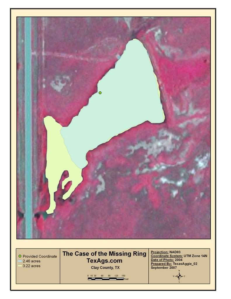
Let's examine the dirt. You said it's a one acre tank. A conservative estimate is ten feet of silt. That's 16,000 cubic yards of dirt. At $125/hour that's gonna be real expensive.
Fossil talked about the water and the problems with removal. I can't imagine any rancher allowing you to drain a stock tank. Water is really hard to come by in Rolling Plains.
Let's examine the dirt. You said it's a one acre tank. A conservative estimate is ten feet of silt. That's 16,000 cubic yards of dirt. At $125/hour that's gonna be real expensive.
Any thoughts on ground penetrating radar? If it's all silt a gold ring should ping pretty hard.
I think getting an accurate idea of the size of the pond is the correct first step. Why don't you get a screen capture of google earth and post it here. We'll need to figure out the scale somehow but that shouldn't be a problem.
the info on a satellite pic will likely be outdated
^
|
|
|
But I bet the tank is still in the same place.
|
|
|
But I bet the tank is still in the same place.
I believe Google Earth has a feature that allows for rough measurements. Click and drag from point A to point B, with the distance given in the measurement of your choice, ie. feet, yards, etc.
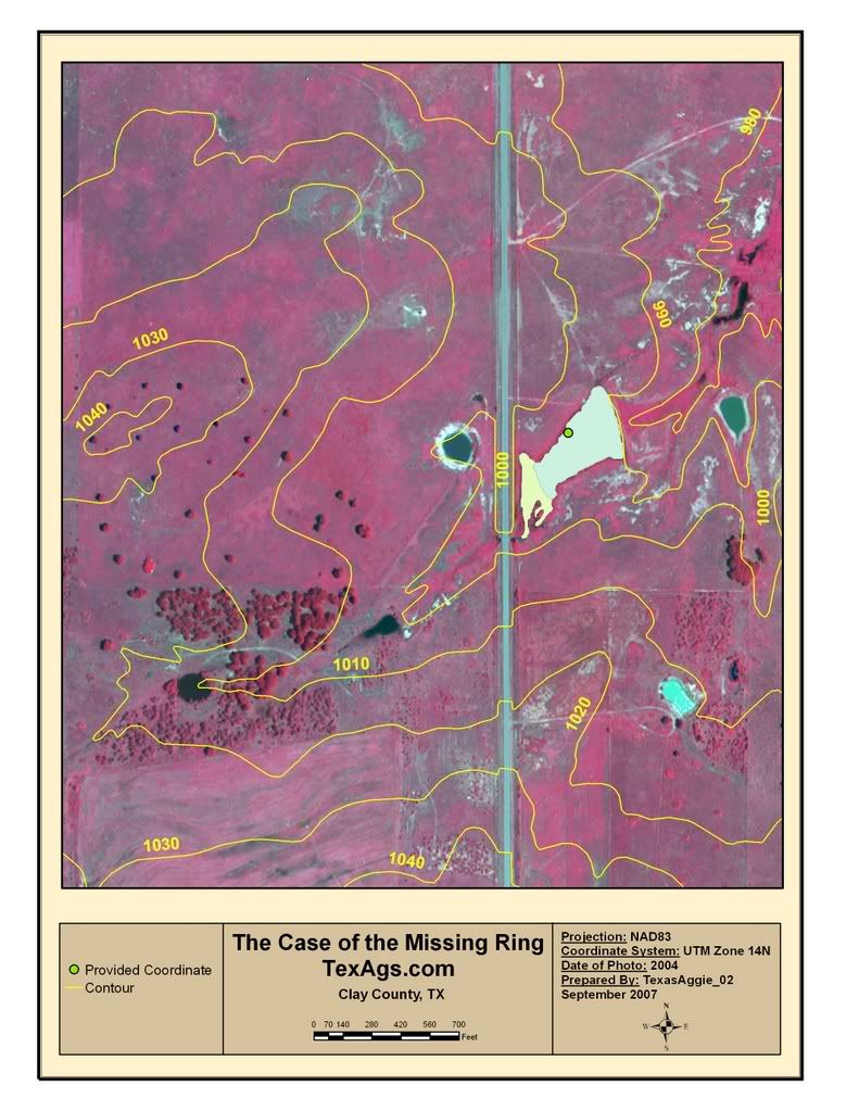
Google Earth also displays elevation figures. Does anyone have any idea about the accuracy of those? Even accuracy in relative terms would be helpful in getting a rough idea of the degree of slope of the surrounding terrain in the watershed ... this would give some idea of the velocity of water traveling to the tank ... which would be one factor in the amount of silt washing in.
We know that soil in Clay County is predominantly sandy loam with clays and shale formations in the lower levels which taken together have a resistance to erosion.
Since the area is predominantly grassland pasture with cultivated land only in bottomlands, we know that grasses in drainage courses have the beneficial value of filtering silt from a flowing sheet of water.
Taken together these factors may allow one to revise downward the amount of silt accumulation in the tank ... even considering its more than 90 years in existance.
Agronomists and Range Science majors ... ideas?
Note: If Google Earth does not have a measurement feature, one can come up with a fair scale by measuring the width of a lane in the vicinity of the tank. Most if moderately traveled will be about 8 feet wide.
Note #2: Some poster was concerned about the rancher being reluctant to part with the water in that stock tank, even if seldom used for stock. Clay County is at the heart of gas well drilling as operators probe into the Barnett Shale. Devon Energy is the largest operator in that area and would be a ready buyer of the water in that tank for its drilling operations. Draining the tank need not be a total loss for the ranch owner.
[This message has been edited by fossil_ag (edited 9/11/2007 5:10p).]
quote:
Note #2: Some poster was concerned about the rancher being reluctant to part with the water in that stock tank, even if seldom used for stock. Clay County is at the heart of gas well drilling as operators probe into the Barnett Shale. Devon Energy is the largest operator in that area and would be a ready buyer of the water in that tank for its drilling operations. Draining the tank need not be a total loss for the ranch owner.
I can't believe I didn't even think of that, and I worked for a water disposal plant those guys use the past 3 summers. Doggone it...
You might do that before December, however, I think I recall the drivers saying something about the whole operation slows down at that point for some reason, don't ask me why.
Call Mike Rowe with "Dirty Jobs". Scuba diving around a dirty pond filled with cow pies for a few hours might be right up his alley.
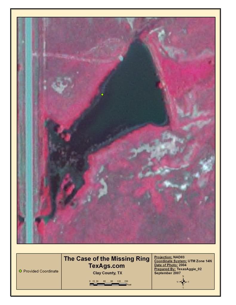
fido, I love that idea and I'm a big fan of Mike Rowe. I may send him an email just for grins and giggles. I am still waiting to hear from the land owners to see about draining options. She said she would discuss and get back with me. I did a rough measurement of the tank, although it was difficult to determine the waters edge (in fact it didn't seem to have a water edge - maybe because of the clarity of the photo). It is approx. 440' x 250'. However, the tank is the shape of a triangle and again, my grandfather was probably swimming near the dam, so realistically, it may not be that big of an area. The dim. is from the farthest points both length and width. I personally don't remember it being that big, but at least it's a ballpark figure.
with all the rain we've had this summer, it may be quite a bit larger now, the satellite photos I have seen are usually several years old
Does that damn release from the bottom?
If so that raises a whole 'nother batch of problems...
If so that raises a whole 'nother batch of problems...
No, the water does not release from the base of the dam, in fact the only drainage is at the opposite, shallow, narrow end. Bottomline, there is no way that ring would find a way out of that tank.
http://www.waterstructures.com/
I have no idea what one these cost, but I have been intrigued by them for a while.
I have no idea what one these cost, but I have been intrigued by them for a while.
I don't know if the question was ever answered:
Is this pond an on-channel impoundment of a tributary?
Is this pond an on-channel impoundment of a tributary?
Tree Hugger ....
Yankees create ponds by on-channel impoundment of a tributary.
Texas ranchers build a stock tank by damming up a gulley.
[This message has been edited by fossil_ag (edited 9/14/2007 8:46a).]
Yankees create ponds by on-channel impoundment of a tributary.
Texas ranchers build a stock tank by damming up a gulley.
[This message has been edited by fossil_ag (edited 9/14/2007 8:46a).]
I wondered what in the hell he was talking about. Thanks for clearing that up.
I am sure this is already mentioned somewhere in the post, but I don't feel like reading it again.
Draining a 1 acre pond is going to cost a lot of time and money. On the other hand, a 1 acre pond is not exceptionally large. That being said, I know they make some really high-tech metal detectors now that can be used in water, to a certain extent. Sure, you will have the headaches of some false pings and trash, but the landowner would probably appreciate you not draining their pond, and in a couple days you could search the entire pond. It may not turn anything up, but if it does you will have saved countless dollars. Just my 2 cents, for what its worth.
Draining a 1 acre pond is going to cost a lot of time and money. On the other hand, a 1 acre pond is not exceptionally large. That being said, I know they make some really high-tech metal detectors now that can be used in water, to a certain extent. Sure, you will have the headaches of some false pings and trash, but the landowner would probably appreciate you not draining their pond, and in a couple days you could search the entire pond. It may not turn anything up, but if it does you will have saved countless dollars. Just my 2 cents, for what its worth.
Roper, those are my thoughts as well, however, I'm not asking the landowner to drain the entire tank; only a couple of feet to make it more manageable. I had mentioned before that the tank was in bad shape a couple of years ago due to drought, but as usual, has come back to normal levels. The owner know that the tank would replenish itself.

No news lately?
quote:
fossil_ag
posted 8:45a, 09/14/07
Tree Hugger ....
Yankees create ponds by on-channel impoundment of a tributary.
Texas ranchers build a stock tank by damming up a gulley.
Ever seen any of the lakes the Soil Conservation Service built in the 40's and 50's?
Give me some coordinates, and I can prolly get a hell of a lot better information about the site for you than you can get off of google earth.
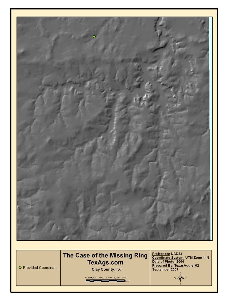
I could pull up data for you using ArcGIS. I'm quiting my job on the 28th, and will be out of pocket awhile due to moving, so if you want any info, let me know pretty soon.
Edit: if you can find the place yourself on Google earth, you can pull some coordinates off of that, and then I can get data. I should be able to get and aerial photo, from which I can calculate the area (i can draw a polygon with an infinite number of vertices and calculate area), I should also be able to get soils and slope data from the USDA and the Texas Natural Resource Information System.
[This message has been edited by TexasAggie_02 (edited 9/18/2007 4:44p).]
^
dang man thats alot of stuff that you can do...pretty sweet
dang man thats alot of stuff that you can do...pretty sweet
I have about 90 percent of texas in quickbird imagery (1 or 2 meter resolution) which is about the best you can do within reason. Give us some coordinates and I will see what I can do.
TexAgs - we find stuff
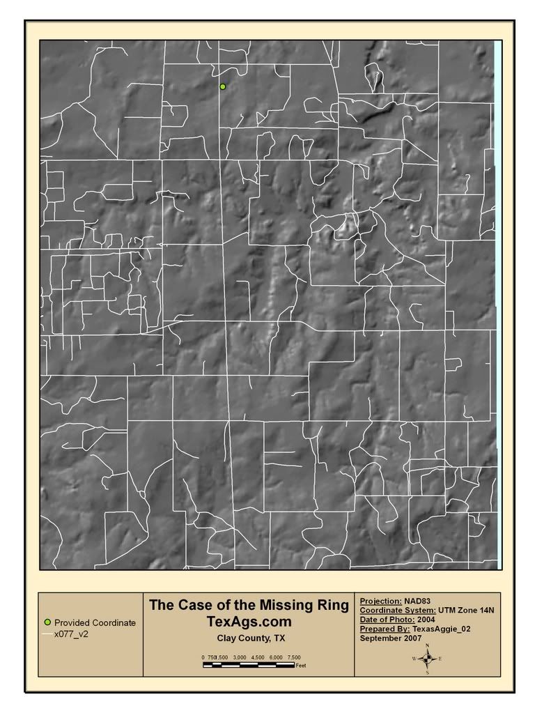
N 33 degrees 36'43" / W 98 degrees 11'57".
I'd be interested to see what you find out. Please keep me informed. I am still waiting to hear from the landowner, however at present, I could go there anytime and start looking. It may just take a small team in a couple of John boats equipped with underwater metal detectors. I talk to some guy in Oregon and he takes numerous trips every year to the beaches and collects all kinds of jewery lost in the ocean and lakes using underwater detectors.
I'd be interested to see what you find out. Please keep me informed. I am still waiting to hear from the landowner, however at present, I could go there anytime and start looking. It may just take a small team in a couple of John boats equipped with underwater metal detectors. I talk to some guy in Oregon and he takes numerous trips every year to the beaches and collects all kinds of jewery lost in the ocean and lakes using underwater detectors.
would you like me to ask other students if they are interested in helping out? I am also checking with my father to see if his company has any equipment in the area that would be of assistance.
quote:
soils and slope data from the USDA and the Texas Natural Resource Information System.
This is public information and is easily viewable in Arc Explorer, a freebie from ESRI to view shapefiles and layers.
I dont have the Qbird imagery of that county, but I am checking on NAIP. Its just as good for these purposes.
[This message has been edited by geogaggie (edited 9/19/2007 7:25a).]
[This message has been edited by geogaggie (edited 9/19/2007 7:36a).]
emkat, I have your imagery. what is your email?
the original images were 1.5 megs each, and a little cripser, if you want me to email them to you.
[This message has been edited by TexasAggie_02 (edited 9/19/2007 9:32a).]
Geo and Texasag you've found it - That's the tank. Somewhere in that body of water lies a mint condition 1913 Aggie Ring. You guys on Texags never cease to amaze me.
Email Address is: chop2467@aol.com
Email Address is: chop2467@aol.com
email sent.
Featured Stories
See All
138:15
6h ago
3.5k
1:55
5h ago
714
Takeaways from Texas A&M baseball's exhibition vs. HCU
by Richard Zane
Texas A&M's next opportunity for progression comes vs. No. 9 Mizzou
by Olin Buchanan