2017 Tropical Fun

7,939 Views | 122 Replies | Last: 6 yr ago by RGV AG
Duckhook
How long do you want to ignore this user?
AG
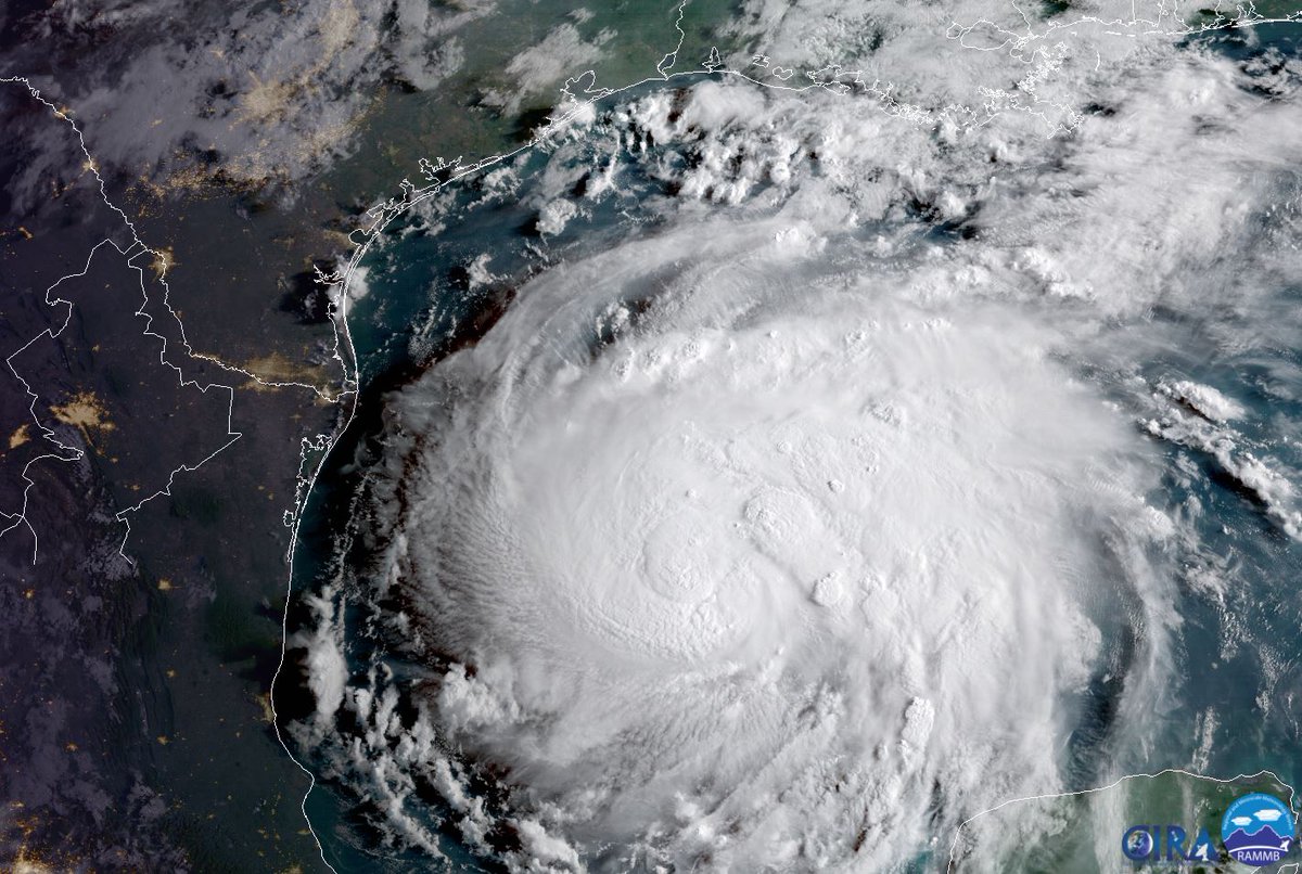
All models trending north of the Valley now. We'll get some rain out of it, but nothing like what the upper coast is going to get. I've got a couple of grown kids in the Houston area and always worry more about them than if something hit us directly.

Beulah was very wet, but the major flooding in Harlingen was due to a flood structure up the Valley either failing or being sabotaged, depending on what story you want to believe. That failure sent a HUGE volume of water flowing down the Arroyo Colorado right through Harlingen.

While there has been a lot of development in the Valley since then, there have also been great strides made in flood control efforts, especially regarding a flooding Rio Grande River. I can't remember what storm it was 6 or 7 years ago, but water was diverted down the floodway from the upper Valley down through Willacy County. It was quite a spectacle to see the floodway full both where the Expressway crosses it in Mercedes as well as at the Cameron/Willacy county line. Pretty impressive amount of water needed to fill it for that long of a stretch.
Eugene4x
How long do you want to ignore this user?
AG
Pretty sure that was Hurricane Alex in summer 2010
RGV AG
How long do you want to ignore this user?
AG
Carl:

In my comment about Dolly being a "dry" storm, what I meant more than anything was that the breadth of the storm didn't drop huge amounts of rain in a large area. Dolly was not a big, in size, storm. Also, I do not remember the spillways holding water from Dolly for a long period of time. I was out of the country and flew in 4 days after the storm to deal with my rental property in PI and I remember driving from McAllen to PI and the spillway had water in it, but nothing like from Hurricane Alex in 2010.

Hurricane Alex was a very large storm and dropped a large amount of rain over a very big area. If I am not mistaken the most recent time the spillway in Mercedes was full for a long time, several weeks, was from Alex and it wasn't so much from rain in the RGV as it was from the rain in the RGV combining with huge inflows into the Rio Grande from Mexico and from up around Del Rio and Eagle Pass. I want to say that 3-4 dams in Mexico were running over for like 2 weeks, and Laredo had the highest or second highest rise in the river there ever recorded. I know I went into Mexico in like August or September and Monterrey and El Cuchillo dam were some torn up.

When I flew out of the RGV after Alex I was shocked to see the spillway so full and all the water standing everywhere. I actually was in PI for Alex and it was not a big deal at all, but I measured like just over 6" of rain there. During Alex Matamoros was basically shutdown for about 3 days due to flooding and like over 50K people in Reynosa had to be evacuated for over 2 weeks.

If there ever is a big ass storm again the disaster is going to be the Mexican side of the RGV, it will be an unbridled mess.
carl spacklers hat
How long do you want to ignore this user?
RGV AG, my apologies, my comment was a little salty. I get what you're saying-Dolly didn't have a lot of mass, unlike your other example, Alex. Maybe my memory is failing on how long water was in the spillway post-Dolly, but for a storm her size, she spilled a lot of rain. Parts of northern Cameron and southern Willacy had standing water for months.

One point I will definitely agree with you on is this: when the RGV and our southern neighbor take a hit from a BIG storm, and it will happen, sooner or later, it will be bad.
RGV AG
How long do you want to ignore this user?
AG
Carl:

No worries, I understand what both you and Duckhook were/are saying. I was remiss in being so general and broad in a statement about Dolly being "dry". In storm vernacular maybe some areas of the RGV, but certainly not all, were somewhat dry. But as you all correctly pointed out some were very wet. The thing that got me about Dolly is that on the face of it, it did not look like a terribly powerful storm.

For instance when I was young, strong, and had hair I lived on the Island and I will never forget the June 1st 1988 storm. That was a thunderstorm along a weather front from the North that blew through the RGV. On the Island it is the storm that knocked down and basically changed the Sea Ranch forever, all the large barns on the east side of the Sea Ranch were blown down and the grocery store and hotel portion of the deal were flooded and roof torn off. Power was lost to SPI for 2 days and there were winds over 100MPH clocked. I want to say about 15 to 20 mobile homes and travel trailers in Isla Blanca were wrecked. They had just issued the 5 year to get out proclamation there, and that storm gave the county a big in on condemning about 75% of the trailers in there.

It tore up a bunch of houses on SPI, and I want to say cratered a couple of old ones and devastated the sorghum and some cotton valley wide that year. But just about 25 miles inland and north that storm was nothing more than a blustery rain maker. But it tore up SPI and PI.
PJYoung
How long do you want to ignore this user?
AG
RGV AG
How long do you want to ignore this user?
AG
From years of watching these things, that storm looks disorganized and spread out. I don't think it will spin up to be a significant wind and surge generator, but maybe the rain will be heavy duty. Last deal I saw is that it is tracking NW instead of WNW, so that starts putting it north of the RGV, and puts the RGV on the dry side of the deal. Who knows. It always seems that when storms come off the Yucatan like this one, in a disorganized state, they either drift almost due west or straight north. But I don't know enough about it, but who knows.
PJYoung
How long do you want to ignore this user?
AG
Yeah certainly tracking N of here at present. Tropicaltidbits.com put up a great video on why last night.

So they say it will officially be a depression at the next 10am update. As ithers have said, flooding will be a huge problem with this.

PJYoung
How long do you want to ignore this user?
AG
Here are the latest 4 spaghetti model runs. All will update live and they are 6 hours apart. Subtract 5 hours from the z time to get our time. As of the 7am run they have certainly shifted back to the south some.


RGV AG
How long do you want to ignore this user?
AG
So in other words they are not quite sure yet are they? Sure is interesting. Has sandbag handing out by the truck load started in the RGV yet? One of the things that made me laugh in the past is that cities would hand out sandbags and limit to like 3 per address or something. Like WTF good is 3 sandbags going to do when the big water comes?
PJYoung
How long do you want to ignore this user?
AG
PJYoung
How long do you want to ignore this user?
AG
PJYoung
How long do you want to ignore this user?
AG
PJYoung
How long do you want to ignore this user?
AG
The last 5 runs of the GFS for 1am Saturday. Back SW towards us a bit.


RGV AG
How long do you want to ignore this user?
AG
Hahaha, they are all over the place here. I would bet this thing drifts in around Corpus, based on nothing more than a guess and years of looking at these things. That storm seems awfully disorganized to me. But who knows.
PJYoung
How long do you want to ignore this user?
AG
The latest 7am run of the Euro is again aimed at us. I would expect the NHC will adjust their track southward at 4pm. We'll see.

RGV AG
How long do you want to ignore this user?
AG
Really? I am in Haiti and I can't follow this as much as the internet is not too good and all the weather sites open up big pictures.

So now they are saying a more westward track than pure northwest? What is your opinion PJ?
PJYoung
How long do you want to ignore this user?
AG
The NHC will update the track every 6 hours - so at 4pm. I am guessing they will adjust it a bit left at that time but nothing crazy.

There is a chance the storm gets into Texas and makes a SW turn instead of bouncing back towards the coast as well. So there's a lot that's undecided right now but I am guessing the official forecast won't be far off.

Watch that tropical tidbits video tonight when Levi does an update. We should have a good idea of what is going to happen then - however - several hurricane forecasters have indicated that this is a particularly complex situation to predict so don't be shocked if they are wildly wrong right now.

Your favorite forecaster - Joe Bastar.di - is still sticking to this track and strength on the forecast he made yesterday morning:

PJYoung
How long do you want to ignore this user?
AG
Yeah they nudged it back to the left some. The 10am cone enveloped most of Louisiana and nothing up the river from us. 3-4 feet of rain N of Corpus over 3 days seems possible if this happens:

RGV AG
How long do you want to ignore this user?
AG
That is some heavy duty water if that track is true. Big time. Storms that I have watched over the years that go stationary tend to drift to the west. But they have been all over the place. I am trying to find if there is a recent position plot with direction or if it is stationary. If it goes down the center the RGV will get 2-3 inches of rain, maybe a little more if it is slow.
PJYoung
How long do you want to ignore this user?
AG
Yeah it hasn't moved much since this morning as the low is reforming I am sure. As it approaches the coast it is supposed to slow down as well.
zarbas77
How long do you want to ignore this user?
AG
*******i does say that he is sticking to his forecasted tract for now, but he admits it could turn southwest towards South Texas and he cites the tracts of Cindy in 1963 and Beulah in '67.
No material on this site is intended to be a substitute for professional medical advice, diagnosis or treatment. See full Medical Disclaimer.
RGV AG
How long do you want to ignore this user?
AG
I am just trying to find the latest deal that has the movement of the storm. All are showing it to be stationary, although one I saw, but couldn'tell what time it was from, had it moving NW at 2mph. I am surprised there hasn't been more wide spread hysteria in south texas.
PJYoung
How long do you want to ignore this user?
AG
Levi's update is up. Really good stuff. 8 minute video

PJYoung
How long do you want to ignore this user?
AG
RGV AG said:

I am just trying to find the latest deal that has the movement of the storm. All are showing it to be stationary, although one I saw, but couldn'tell what time it was from, had it moving NW at 2mph. I am surprised there hasn't been more wide spread hysteria in south texas.
RGV AG
How long do you want to ignore this user?
AG
That was a really cool video, but I am just as clueless as before, hahaha. It sounds like a chance that it could head in near the valley, but nothing certain. Looks like a drought breaker for sure.
Duckhook
How long do you want to ignore this user?
AG
Just curious about Levi. That was a good video but first time I've seen anything from him. What are his credentials? Really knowledgeable amateur or is he in the business?
Duckhook
How long do you want to ignore this user?
AG
Hmm. Most of the 00z model runs show the storm tracking west and southwest once it hits land.
PJYoung
How long do you want to ignore this user?
AG
Duckhook said:

Just curious about Levi. That was a good video but first time I've seen anything from him. What are his credentials? Really knowledgeable amateur or is he in the business?


Last year he was a PhD candidate at FSU if I recall correctly. He gets retweeted all of the time by the big guys so he and his site are well respected.

I was very impressed with him last season. He is a no hype guy, just lays the facts out there.
PJYoung
How long do you want to ignore this user?
AG
Duckhook said:

Hmm. Most of the 00z model runs show the storm tracking west and southwest once it hits land.


Yep. Interesting, huh? The latest run would make it way more wet for us and our lakes.
PJYoung
How long do you want to ignore this user?
AG
Only down to 1003 mb as of a few minutes ago. Probably not gonna get the TS designation til morning.
RGV AG
How long do you want to ignore this user?
AG
Looks like they jogged the track north some at the 4:00am update. I think that is the case if I am reading it right. The Accuweather tracker has it moving to the north at 10mph which is a large change from stationary-2mph to the NW. As this storm develops I think they will get more dialed in on what it is going to do obviously, but one has to wonder at what stage will it be well predicted.
PJYoung
How long do you want to ignore this user?
AG
Yep that was a reformation of the low to the north which has thrown the track north back towards Corpus.

It sure looks close to us this morning.

The big ticket news item overnight is the rapid intensification that Harvey has undergone. There was a possibility for this before but now this should be a very strong Cat 1 or a Cat 2 before landfall. Worst case would be it spinning up to a Cat 3 but that would depend on the track and how much time it has before getting onshore.

Eric Blake said trying to predict which way it goes once onshore right now is like predicting which way a marble rolls on a flat surface. Hence the stalling and large scale rain/flooding threat. Good news for us is that we're still predicted to be on the relatively drier southern side.


PJYoung
How long do you want to ignore this user?
AG
Duckhook
How long do you want to ignore this user?
AG
Comparing that satellite pic to 12 hours ago. Wow. Hard to believe it's the same storm. Still think we're okay wind-wise in the Valley. Models now aren't looping it back west and southwest after landfall.
 
×
subscribe Verify your student status
See Subscription Benefits
Trial only available to users who have never subscribed or participated in a previous trial.