

Any one have spring/summer precip predictions from the weather folks?
Rain is outdoors.....
1,311,019 Views |
7090 Replies |
Last: 3 hrs ago by TikkaShooter
Hope those predictions are hot and dry. Most of the emphasis on dry.
Temps most likely at or below average and definitely not like last summer. Rainfall at or above average. Reservoirs are at 90% full which has a direct correlation to summer temps.
I can't believe scattered 1-2" rain took the Brazos from 15' to projected 34' without any rain the last few weeks.
This river has changed radically.
This river has changed radically.
1. It was a lot more than scattered 1"-2" of rain. The middle, lower and parts of the upper basin were hit hard with the fronts that passed through a couple of days ago. And the Brazos has a pretty big watershed.cbr said:
I can't believe scattered 1-2" rain took the Brazos from 15' to projected 34' without any rain the last few weeks.
This river has changed radically.
2. The world is still wet. Yes, I know that some folks are seeing cracks in their yards - but that is literally only at the surface. The ground is still saturated from the last couple of years of wet weather. Runoff is going to be high for a long time as a result with any rain system.
LiveOak said:
Any one have spring/summer precip predictions from the weather folks?
Some Shiner folks cut some onions and predict there will be ice in April. Not sure if it will be hail or freeze though. Also predicted April to be wet.
LiveOak said:
Any one have spring/summer precip predictions from the weather folks?
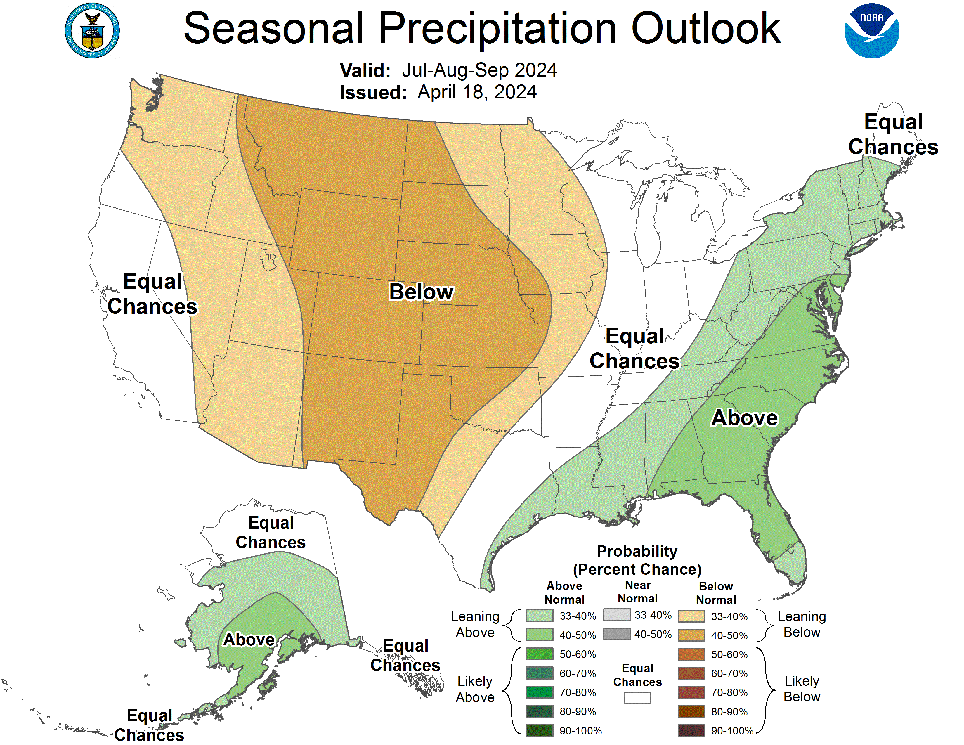
What's the projected rainfall?
Anything changed lately.
Anything changed lately.
Rough outlook for East TX into LA Saturday for severe weather.
...MAXIMUM RISK BY HAZARD...
Tornado: 15% SIG - Moderate
Wind: 45% - Enhanced
Hail: 15% - Slight

Day 2 Convective Outlook
NWS Storm Prediction Center Norman OK
1227 PM CDT Fri Apr 12 2019
Valid 131200Z - 141200Z
...THERE IS A MODERATE RISK OF SEVERE THUNDERSTORMS FOR NORTHERN
LOUISIANA...SOUTHERN ARKANSAS...AND SMALL PORTIONS OF WESTERN
MISSISSIPPI AND EAST TEXAS...
...SUMMARY...
Numerous severe thunderstorms capable primarily of damaging winds
and tornadoes, are expected across portions of east Texas,
Louisiana, southern Arkansas, Mississippi and surrounding areas
Saturday and Saturday night.
...Synopsis...
A vigorous mid-level trough initially over the Southern Rockies will
pivot eastward through the southern Great Plains and into the
western part of the Ozark Plateau by Sunday morning. A surface low
over the TX Hill Country will develop northeastward and deepen and
reach the vicinity of the confluence of the Ohio and Mississippi
Rivers. Trailing from this low, a cold front will sweep across east
Texas to near the Sabine River by sunset, and then continue eastward
across the lower Mississippi River into Mississippi and eventually
western Alabama.
...East-central TX eastward into western AL...
Southerly low-level flow will transport an increasingly moisture
rich airmass northward into the Arklatex and lower MS Valley during
the day. It is likely showers and thunderstorms, some potentially
capable of severe gusts and large hail, will be ongoing across
central TX into northeast TX prior to midday. Surface heating
within the destabilizing warm sector will lead to moderate buoyancy
(MLCAPE 1000-2000 J/kg) over the Sabine Valley and LA by early to
mid afternoon. Strong flow veering/increasing with height from
southeasterly to south-southwesterly, and reaching 60 to 70 kt at
mid levels, will support well-organized rotating updrafts with the
stronger storms. Convection will continue spreading eastward
through the evening and into the overnight hours.
Some lingering questions about the tornado risk remain due in part
to some conditional factors yet to occur. However, it appears the
tornado risk may maximize in 2 corridors. First, a diurnally
focused tornado risk (primarily supercellular) across northern LA
into far southern AR vicinity between 3-9pm. A second area of
potential concern may focus from northeast LA near the MS River
east-northeast across central and into parts of northeast/east MS
during the evening into the overnight. A mix mode of supercell/QLCS
or hybridization of the two within a convective line are possible.
Along with damaging gusts, strong tornadoes may also occur with a
few of the most intense storms. While the pre-frontal, cellular
convection should diminish overnight, a semi-organized band of
storms -- with embedded rotating updrafts and continued
severe/tornado potential -- will move across the central Gulf Coast
states through the end of the period.
...North Carolina/southeast Virginia and vicinity...
Models forecast that the eastern fringe of a warm front associated
with the developing south-central U.S. storm system will lie across
the Carolinas/Virginia vicinity during the day. With some heating
of a moist low-level airmass yielding around 1000 J/kg mixed-layer
CAPE during the afternoon, scattered/diurnally driven thunderstorms
are expected. While not excessive, shear -- aided by 35 kt
mid-level west-southwesterlies -- will be sufficient for storm
organization, and thus risk that a couple of storms reach severe
levels. Hail and gusty/locally damaging winds would be the primary
severe risk, before storms weaken into the evening hours.
...MAXIMUM RISK BY HAZARD...
Tornado: 15% SIG - Moderate
Wind: 45% - Enhanced
Hail: 15% - Slight
..Smith.. 04/12/2019
CLICK TO GET WUUS02 PTSDY2 PRODUCT
NOTE: THE NEXT DAY 2 OUTLOOK IS SCHEDULED BY 0600Z
CURRENT UTC TIME: 0205Z (9:05PM), RELOAD THIS PAGE TO UPDATE THE TIME
...MAXIMUM RISK BY HAZARD...
Tornado: 15% SIG - Moderate
Wind: 45% - Enhanced
Hail: 15% - Slight
Day 2 Convective Outlook
NWS Storm Prediction Center Norman OK
1227 PM CDT Fri Apr 12 2019
Valid 131200Z - 141200Z
...THERE IS A MODERATE RISK OF SEVERE THUNDERSTORMS FOR NORTHERN
LOUISIANA...SOUTHERN ARKANSAS...AND SMALL PORTIONS OF WESTERN
MISSISSIPPI AND EAST TEXAS...
...SUMMARY...
Numerous severe thunderstorms capable primarily of damaging winds
and tornadoes, are expected across portions of east Texas,
Louisiana, southern Arkansas, Mississippi and surrounding areas
Saturday and Saturday night.
...Synopsis...
A vigorous mid-level trough initially over the Southern Rockies will
pivot eastward through the southern Great Plains and into the
western part of the Ozark Plateau by Sunday morning. A surface low
over the TX Hill Country will develop northeastward and deepen and
reach the vicinity of the confluence of the Ohio and Mississippi
Rivers. Trailing from this low, a cold front will sweep across east
Texas to near the Sabine River by sunset, and then continue eastward
across the lower Mississippi River into Mississippi and eventually
western Alabama.
...East-central TX eastward into western AL...
Southerly low-level flow will transport an increasingly moisture
rich airmass northward into the Arklatex and lower MS Valley during
the day. It is likely showers and thunderstorms, some potentially
capable of severe gusts and large hail, will be ongoing across
central TX into northeast TX prior to midday. Surface heating
within the destabilizing warm sector will lead to moderate buoyancy
(MLCAPE 1000-2000 J/kg) over the Sabine Valley and LA by early to
mid afternoon. Strong flow veering/increasing with height from
southeasterly to south-southwesterly, and reaching 60 to 70 kt at
mid levels, will support well-organized rotating updrafts with the
stronger storms. Convection will continue spreading eastward
through the evening and into the overnight hours.
Some lingering questions about the tornado risk remain due in part
to some conditional factors yet to occur. However, it appears the
tornado risk may maximize in 2 corridors. First, a diurnally
focused tornado risk (primarily supercellular) across northern LA
into far southern AR vicinity between 3-9pm. A second area of
potential concern may focus from northeast LA near the MS River
east-northeast across central and into parts of northeast/east MS
during the evening into the overnight. A mix mode of supercell/QLCS
or hybridization of the two within a convective line are possible.
Along with damaging gusts, strong tornadoes may also occur with a
few of the most intense storms. While the pre-frontal, cellular
convection should diminish overnight, a semi-organized band of
storms -- with embedded rotating updrafts and continued
severe/tornado potential -- will move across the central Gulf Coast
states through the end of the period.
...North Carolina/southeast Virginia and vicinity...
Models forecast that the eastern fringe of a warm front associated
with the developing south-central U.S. storm system will lie across
the Carolinas/Virginia vicinity during the day. With some heating
of a moist low-level airmass yielding around 1000 J/kg mixed-layer
CAPE during the afternoon, scattered/diurnally driven thunderstorms
are expected. While not excessive, shear -- aided by 35 kt
mid-level west-southwesterlies -- will be sufficient for storm
organization, and thus risk that a couple of storms reach severe
levels. Hail and gusty/locally damaging winds would be the primary
severe risk, before storms weaken into the evening hours.
...MAXIMUM RISK BY HAZARD...
Tornado: 15% SIG - Moderate
Wind: 45% - Enhanced
Hail: 15% - Slight
..Smith.. 04/12/2019
CLICK TO GET WUUS02 PTSDY2 PRODUCT
NOTE: THE NEXT DAY 2 OUTLOOK IS SCHEDULED BY 0600Z
CURRENT UTC TIME: 0205Z (9:05PM), RELOAD THIS PAGE TO UPDATE THE TIME
Thanks!
Link to photos of Franklin damage. http://montgomerycountypolicereporter.com/tornado-damages-franklin-texas/
That tweet about the golf course, for some reason, just gets me with a very real feeling of WGAS.
The membership that won't get to play for a while, those that enjoy playing there, and those that will have to cut the check to pay to repair it.
Human lives are priceless. However, everything else is property just the same regardless if it's important to you or not.
Human lives are priceless. However, everything else is property just the same regardless if it's important to you or not.
Apparently some media outlets are falsely reporting that two kids were killed in Franklin. No surprise that they don't fact check first.
I agree that human life is priceless. People that lost their homes probably won't buy a "it's just property" argument.
Kenneth_2003 said:
I agree that human life is priceless. People that lost their homes probably won't buy a "it's just property" argument.
Probably not. They have an emotional attachment to their property even if it's insured. Just like they're emotionally attached to their dog, that is also property.
That golf course will lose revenue, be down for repair, and have to cut a check. The owners, management, staff that count on the course for income are probably a little upset as well.
All the same to those impacted if you look at it objectively.
we're a few miles southwest of Franklin... lots of rainfall... each bout is around 5-8 inches... Looks like another bout of severe weather this Wednesday. The ground is so saturated right now, you can barely drive a small tractor without sinking. Frustrating stuff...
danieljustin06 said:
Apparently some media outlets are falsely reporting that two kids were killed in Franklin. No surprise that they don't fact check first.
Two were killed in Pollack, not Franklin.
That was a heck of a storm this morning in DeWitt. Had all 3 kids in our bed this morning before it was finally over with all the lightning and wind.
Haven't checked the gauge yet for total.
Haven't checked the gauge yet for total.
Had 1.5" towards snook when I left at 5 this morning and still coming down
1.6" in southern Wilson County. Some hail but haven't noticed any damage.
1.7" near Rudder High School in Bryan. Looks like the rain is about to clear out.
2.5 here in central Bastrop county. With all the previous rain we've had over the past 2 weeks, water is standing everywhere in my pastures. Just fertilized the hay patches yesterday.
Been raining all day on us here in Seguin.
Starting to drizzle at the King Ranch north of Premont.
Trying to see the gauge without going out there and getting soaked but it looks close to 4.25
We are between Waco and mcgregor.
We are between Waco and mcgregor.
Outside of Franklin. Raining hard but it seems the tornadic activity is south of us and heading east. Not sure my nerves could take yet another hit again. The pasture hasn't dried up enough to even clean up from the last tornado that took out over a dozen of 100+ year old oaks.
At least we still have power for now.
At least we still have power for now.
Featured Stories
See All
No. 7 A&M seeks to respond vs. No. 6 Tennessee on Saturday morning
by Olin Buchanan
LIVE from Blue Bell Park: No. 1 Texas A&M vs. Cal Poly (Friday)
by Richard Zane
40:51
4h ago
2.0k
13:04
5h ago
978
Henry Coleman III 'excited' for Saturday's showdown with Tennessee
by Luke Evangelist
Scouting Report: No. 7 Texas A&M vs. No. 6 Tennessee
by Tom Schuberth