This came up in a discussion on the Outdoors Board, and I decided it belonged here.
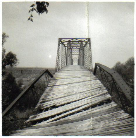
"The Old Iron Bridge" was on the Brazos somewhere southwest of Easterwood airport and downstream from the FM60 crossing of the Brazos. At some time in the past, there had been a bridge, but by my day in the mid to late 1970s, there was only a dirt road that dead-ended at the river, and some iron pilings still in the middle of the Brazos. When Koppe Bridge hamburger joint opened, I wondered if "Koppe" had been the real name of it.
As a fish and a phead, I was often one of the few in the dorms on weekends, as I lived far from A&M and the local guys would go home. So I would get in my car and drive the back roads. Found many interesting things, including TOIB. It was already known to generations of Ags, and a favorite place for shooting weapons, imbibing ethanol, and converting virgins. Strangely, the first two of those will now get you in more trouble than the third one.
Memory tells me that it was at the end of Koppe Bridge Road and Batt's Ferry Road http://g.co/maps/ayn87
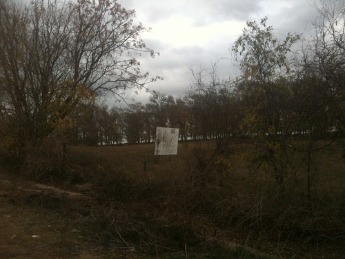
But any trace of the pilings is long gone. A little upstream, though is the end of Hope's creek road, which does seem to have some debris. http://g.co/maps/rm25v
From the photos, that looks more like it, but from the roads and the way the road goes down to the river, I'd say TOIB was at Batt's Ferry.
Other info I've found online
Directions to Batts Ferry, Brazos County.
Batt's Ferry Neighborhood
Pittsbridge Texas
I'm thinking Pittsbridge must have been near the A&M Annex (old Bryan AFB) at the end of Pitt's Road.
Linkeroonie
[This message has been edited by CanyonAg77 (edited 12/12/2011 10:39p).]
"The Old Iron Bridge" was on the Brazos somewhere southwest of Easterwood airport and downstream from the FM60 crossing of the Brazos. At some time in the past, there had been a bridge, but by my day in the mid to late 1970s, there was only a dirt road that dead-ended at the river, and some iron pilings still in the middle of the Brazos. When Koppe Bridge hamburger joint opened, I wondered if "Koppe" had been the real name of it.
As a fish and a phead, I was often one of the few in the dorms on weekends, as I lived far from A&M and the local guys would go home. So I would get in my car and drive the back roads. Found many interesting things, including TOIB. It was already known to generations of Ags, and a favorite place for shooting weapons, imbibing ethanol, and converting virgins. Strangely, the first two of those will now get you in more trouble than the third one.
Memory tells me that it was at the end of Koppe Bridge Road and Batt's Ferry Road http://g.co/maps/ayn87
But any trace of the pilings is long gone. A little upstream, though is the end of Hope's creek road, which does seem to have some debris. http://g.co/maps/rm25v
From the photos, that looks more like it, but from the roads and the way the road goes down to the river, I'd say TOIB was at Batt's Ferry.
Other info I've found online
Directions to Batts Ferry, Brazos County.
quote:
1- From Campus, Take Wellborn Road (FM 2154) south to Wellborn, about 4 miles.
2- In Wellborn, turn right across the railroad tracks at the intersection directly in front of
the Post Office and Junek’s Grocery Store.
3- Immediately turn left after crossing the tracks onto Koppe Bridge road.
4- Continue south on Koppe Bridge Road until it turns to the right (Southwest) at about
0.2 miles (right after passing Koppe Cuts Hair Salon).
5- Proceed straight through an intersection with a stop sign, another 0.2 miles.
6- Proceed straight through an intersection (Horn Road) at about 2.6 miles, the road
becomes Batts Ferry Road and will turn to dirt.
7- At about 3.2 miles your will see Batts Ferry Compression Station (gas well?) on your left.
8- Stop at end of road, 3.6 miles (don’t drive into Brazos River!) and park.
9- To your right you will see a berm of pushed-up earth. Climb over the berm, and
proceed towards river across graded area. The best leaf litter is under the cottonwood
trees on a bench about 10 feet above the river. The litter on the banks of the river below
the bench has been scoured and is too thin.
Batt's Ferry Neighborhood
quote:
Batts Ferry Neighborhood
compiled by Bill Page
8 August 2007
Batt’s Ferry was located on the Brazos River, in the southern part of Brazos County. A
small community grew up around the ferry.
Batts Ferry was the terminus of a proposed road from Bryan to the Brazos River in 1872.
The ferry was operated by Jesse Batts. (Brazos County Commissioners Minutes, Book B,
page 209).
A Negro named Charlie Robinson was drowned in the Brazos River at Batte’s Ferry
Saturday. (weekly) Bryan Eagle, 4 July 1895, page 3, col.1.
In a difficulty over a game of cards near Batte's ferry one of the Negroes, named Sam
Jackson was shot twice and probably fatally wounded. (weekly) Bryan Eagle, 26
November 1896, page 7, col.2
Ed Hefley, colored, has surrendered to the authorities of Burleson County for the
shooting of Sam Jackson, another Negro, near Batte's Ferry Sunday afternoon. (weekly)
Bryan Eagle, 26 November 1896, page 7, col.4
Bryan, Tex., Aug. 1 – Reports from all points on the Brazos River late this evening say
that the flood is receding rapidly ... At Battes Ferry, in the lower bottom, a fall of eight
inches is reported and the water is running down rapidly ... Dallas Morning News, 2
August 1902, page 3
The members of the Brazos and Burleson County Commissioners’ courts will visit
Batte’s Ferry Friday to investigage conditions there with a view to the proposed new
bridge across the Brazos. A barbecue will be given them on the plantation of T.R. Batte.
(weekly) Bryan Eagle, 28 May 1903, p.2, col.3
The members of the Brazos and Burleson County Commissioners’ courts, members of
the Bryan business league, business men and other citizens of the town and county
interested spent the day yesterday at Batte’s Ferry looking over the ground and
considering the proposition to bridge the Brazos River at or near that point. The
necessity for such a bridge is generally conceded, and there is no question but what the
people desiring it most are entitled to it. The authorities have so far shown a willingness
to do all they can in the matter and we hope they will see their way clear to carry out the
project without delay. One of the enjoyable features of the day was a fine barbecue
served on the plantation of T.R. Batte. (weekly) Bryan Eagle, 4 June 1903, p.5, col.4
Bryan … At the meeting of the Bryan Business League … a number of important matters
were discussed for developing the trade of the town and committees appointed to look
after them. Among them was a proposition to petition the Commissioners’ Court to lease
the Pitts Ferry toll bridge and the Battes Ferry on the Brazos River, between Brazos and
2
Burleson Counties and make both of them free, as an inducement to bring trade to Bryan.
This will likely be done …. Dallas Morning News, 4 August 1903, p.10.
A petition to the commissioners court to lease the Pitts Bridge and Batte’s Ferry, and
make both free to the public, in accordance with the plans outlined at the last meeting of
the business league, has been circulated and liberally signed on the streets the past two
days. (weekly) Bryan Eagle, 13 August 1903, p.5, col.1
Henry Hodges and Frank Wilson were here from Batte’s Ferry yesterday. Bryan Weekly
Eagle, 29 September 1904, page 6
W.H. Bell of Batte’s Ferry was in town yesterday. Bryan Weekly Eagle, 3 November
1904, page 2
Mrs. Frank Wilson and children of Batte’s Ferry were in the city yesterday. Bryan
Weekly Eagle, 1 December 1904, page 2
Bryan ... The Commissioners' Court has also leased the Batte's ferry, lower down the
river, from T.R. Batte and will operate the same free to the public. ... Galveston Daily
News, 26 February 1905, page ? [on page with Denderine ad]
“Battes Ferry,” (weekly) Bryan Eagle, 17 August 1905, p.1, col.4. It is in good shape.
“Volney McLendon,” Brazos Pilot, 24 August 1905, page 5. Died at Batte’s Ferry.
T.W. Worthington was here from the Batte’s Ferry neighborhood yesterday. Bryan
Weekly Eagle, 3 January 1907, page 7
*John Woods, an African American, was killed near Batte’s Ferry. Bryan Weekly Eagle,
3 October 1907, page 7
John Woods, colored, living on the J.W. Coulter farm in the Brazos bottom was shot last
night by the officers while resisting arrest. Woods is wanted in Limestone County for
carrying a pistol and when the officers went to his house to place him under arrest,
resisted and was shot. A telephone message from there today stated that he was still
alive, but his wounds were fatal. Brazos Pilot, 3 October 1907, p.7
Pittsbridge Texas
quote:
PITTSBRIDGE, TEXAS. Pittsbridge, also known as Evans Ferry and Pitt's Ferry, was on the west bank of the Brazos River thirteen miles northeast of Caldwell in extreme eastern Burleson County. It sprang up after the Civil War at the site of the first bridge to span the Brazos between Burleson and Brazos counties. A ferry was operated by Charles J. and T. C. Evans below the mouth of the Little Brazos River as early as 1868, when Burleson County extended the Evans Ferry Road to a point on the west bank about three miles downstream from the point where State Highway 21 now crosses the Brazos. A Mr. Pitt was superintendent of this road, which linked the towns of Caldwell and Bryan, and by 1870 Evans Ferry had been renamed Pitt's Ferry. Pitt's Bridge was built at the site of the ferry in 1875. By 1878 the settlement of Pittsbridge, on the western end of the span, had acquired a post office; it was discontinued in 1891. In the early 1890s a number of Italian immigrants reached Burleson County, many of them taking up farming in the Brazos bottomlands, including the Pittsbridge vicinity. The town remained a small agricultural community. The nearby bridge did not long enjoy its status as the county's only bridge on the river; by 1892 a new iron bridge had been constructed a few miles downstream at Jones Bluff, and another opened at Koppe's Ferry in 1908. Pitt's Bridge, a wooden structure, was rendered impassible by flood damage in the early 1890s and again in 1913, 1921, and 1926. In 1933 Pittsbridge had an estimated population of twenty and one business. Estimates remained at this level for decades; in 1967, the last year for which figures were available, the population stood at twenty. The community dwindled rapidly thereafter, and by the early 1970s Pittsbridge had disappeared. As recently as the mid-1980s two piers of Pitt's Bridge could still be seen below the confluence of the Little Brazos from Burleson County Road 227.
BIBLIOGRAPHY:
Glenna Fourman Brundidge, Brazos County History: Rich Past-Bright Future (Bryan, Texas: Family History Foundation, 1986).
I'm thinking Pittsbridge must have been near the A&M Annex (old Bryan AFB) at the end of Pitt's Road.
Linkeroonie
[This message has been edited by CanyonAg77 (edited 12/12/2011 10:39p).]

 [/url]


 . With an inexpensive telephoto lens you can get some shots of what looks to be a lock structure upstream of the bridge.

