The Old Iron Bridge

38,934 Views | 73 Replies | Last: 5 mo ago by iamtheglove
CanyonAg77
How long do you want to ignore this user?
AG
This came up in a discussion on the Outdoors Board, and I decided it belonged here.

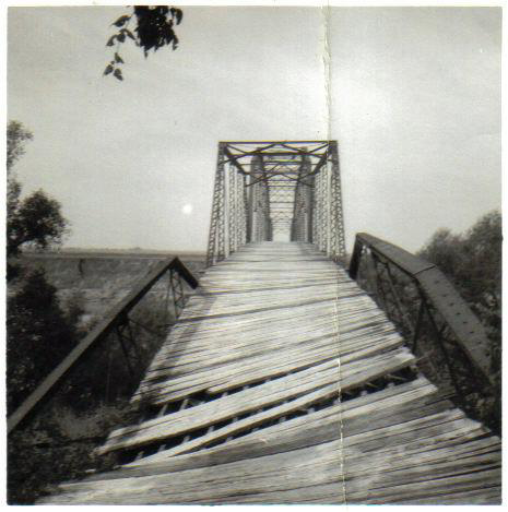
"The Old Iron Bridge" was on the Brazos somewhere southwest of Easterwood airport and downstream from the FM60 crossing of the Brazos. At some time in the past, there had been a bridge, but by my day in the mid to late 1970s, there was only a dirt road that dead-ended at the river, and some iron pilings still in the middle of the Brazos. When Koppe Bridge hamburger joint opened, I wondered if "Koppe" had been the real name of it.

As a fish and a phead, I was often one of the few in the dorms on weekends, as I lived far from A&M and the local guys would go home. So I would get in my car and drive the back roads. Found many interesting things, including TOIB. It was already known to generations of Ags, and a favorite place for shooting weapons, imbibing ethanol, and converting virgins. Strangely, the first two of those will now get you in more trouble than the third one.

Memory tells me that it was at the end of Koppe Bridge Road and Batt's Ferry Road http://g.co/maps/ayn87

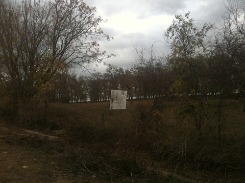
But any trace of the pilings is long gone. A little upstream, though is the end of Hope's creek road, which does seem to have some debris. http://g.co/maps/rm25v

From the photos, that looks more like it, but from the roads and the way the road goes down to the river, I'd say TOIB was at Batt's Ferry.

Other info I've found online

Directions to Batts Ferry, Brazos County.
quote:
1- From Campus, Take Wellborn Road (FM 2154) south to Wellborn, about 4 miles.
2- In Wellborn, turn right across the railroad tracks at the intersection directly in front of
the Post Office and Junek’s Grocery Store.
3- Immediately turn left after crossing the tracks onto Koppe Bridge road.
4- Continue south on Koppe Bridge Road until it turns to the right (Southwest) at about
0.2 miles (right after passing Koppe Cuts Hair Salon).
5- Proceed straight through an intersection with a stop sign, another 0.2 miles.
6- Proceed straight through an intersection (Horn Road) at about 2.6 miles, the road
becomes Batts Ferry Road and will turn to dirt.
7- At about 3.2 miles your will see Batts Ferry Compression Station (gas well?) on your left.
8- Stop at end of road, 3.6 miles (don’t drive into Brazos River!) and park.
9- To your right you will see a berm of pushed-up earth. Climb over the berm, and
proceed towards river across graded area. The best leaf litter is under the cottonwood
trees on a bench about 10 feet above the river. The litter on the banks of the river below
the bench has been scoured and is too thin.

Batt's Ferry Neighborhood
quote:
Batts Ferry Neighborhood
compiled by Bill Page
8 August 2007
Batt’s Ferry was located on the Brazos River, in the southern part of Brazos County. A
small community grew up around the ferry.
Batts Ferry was the terminus of a proposed road from Bryan to the Brazos River in 1872.
The ferry was operated by Jesse Batts. (Brazos County Commissioners Minutes, Book B,
page 209).

A Negro named Charlie Robinson was drowned in the Brazos River at Batte’s Ferry
Saturday. (weekly) Bryan Eagle, 4 July 1895, page 3, col.1.

In a difficulty over a game of cards near Batte's ferry one of the Negroes, named Sam
Jackson was shot twice and probably fatally wounded. (weekly) Bryan Eagle, 26
November 1896, page 7, col.2

Ed Hefley, colored, has surrendered to the authorities of Burleson County for the
shooting of Sam Jackson, another Negro, near Batte's Ferry Sunday afternoon. (weekly)
Bryan Eagle, 26 November 1896, page 7, col.4

Bryan, Tex., Aug. 1 – Reports from all points on the Brazos River late this evening say
that the flood is receding rapidly ... At Battes Ferry, in the lower bottom, a fall of eight
inches is reported and the water is running down rapidly ... Dallas Morning News, 2
August 1902, page 3

The members of the Brazos and Burleson County Commissioners’ courts will visit
Batte’s Ferry Friday to investigage conditions there with a view to the proposed new
bridge across the Brazos. A barbecue will be given them on the plantation of T.R. Batte.
(weekly) Bryan Eagle, 28 May 1903, p.2, col.3

The members of the Brazos and Burleson County Commissioners’ courts, members of
the Bryan business league, business men and other citizens of the town and county
interested spent the day yesterday at Batte’s Ferry looking over the ground and
considering the proposition to bridge the Brazos River at or near that point. The
necessity for such a bridge is generally conceded, and there is no question but what the
people desiring it most are entitled to it. The authorities have so far shown a willingness
to do all they can in the matter and we hope they will see their way clear to carry out the
project without delay. One of the enjoyable features of the day was a fine barbecue
served on the plantation of T.R. Batte. (weekly) Bryan Eagle, 4 June 1903, p.5, col.4

Bryan … At the meeting of the Bryan Business League … a number of important matters
were discussed for developing the trade of the town and committees appointed to look
after them. Among them was a proposition to petition the Commissioners’ Court to lease
the Pitts Ferry toll bridge and the Battes Ferry on the Brazos River, between Brazos and
2
Burleson Counties and make both of them free, as an inducement to bring trade to Bryan.
This will likely be done …. Dallas Morning News, 4 August 1903, p.10.

A petition to the commissioners court to lease the Pitts Bridge and Batte’s Ferry, and
make both free to the public, in accordance with the plans outlined at the last meeting of
the business league, has been circulated and liberally signed on the streets the past two
days. (weekly) Bryan Eagle, 13 August 1903, p.5, col.1

Henry Hodges and Frank Wilson were here from Batte’s Ferry yesterday. Bryan Weekly
Eagle, 29 September 1904, page 6

W.H. Bell of Batte’s Ferry was in town yesterday. Bryan Weekly Eagle, 3 November
1904, page 2

Mrs. Frank Wilson and children of Batte’s Ferry were in the city yesterday. Bryan
Weekly Eagle, 1 December 1904, page 2

Bryan ... The Commissioners' Court has also leased the Batte's ferry, lower down the
river, from T.R. Batte and will operate the same free to the public. ... Galveston Daily
News, 26 February 1905, page ? [on page with Denderine ad]

“Battes Ferry,” (weekly) Bryan Eagle, 17 August 1905, p.1, col.4. It is in good shape.

“Volney McLendon,” Brazos Pilot, 24 August 1905, page 5. Died at Batte’s Ferry.

T.W. Worthington was here from the Batte’s Ferry neighborhood yesterday. Bryan
Weekly Eagle, 3 January 1907, page 7

*John Woods, an African American, was killed near Batte’s Ferry. Bryan Weekly Eagle,
3 October 1907, page 7

John Woods, colored, living on the J.W. Coulter farm in the Brazos bottom was shot last
night by the officers while resisting arrest. Woods is wanted in Limestone County for
carrying a pistol and when the officers went to his house to place him under arrest,
resisted and was shot. A telephone message from there today stated that he was still
alive, but his wounds were fatal. Brazos Pilot, 3 October 1907, p.7

Pittsbridge Texas
quote:
PITTSBRIDGE, TEXAS. Pittsbridge, also known as Evans Ferry and Pitt's Ferry, was on the west bank of the Brazos River thirteen miles northeast of Caldwell in extreme eastern Burleson County. It sprang up after the Civil War at the site of the first bridge to span the Brazos between Burleson and Brazos counties. A ferry was operated by Charles J. and T. C. Evans below the mouth of the Little Brazos River as early as 1868, when Burleson County extended the Evans Ferry Road to a point on the west bank about three miles downstream from the point where State Highway 21 now crosses the Brazos. A Mr. Pitt was superintendent of this road, which linked the towns of Caldwell and Bryan, and by 1870 Evans Ferry had been renamed Pitt's Ferry. Pitt's Bridge was built at the site of the ferry in 1875. By 1878 the settlement of Pittsbridge, on the western end of the span, had acquired a post office; it was discontinued in 1891. In the early 1890s a number of Italian immigrants reached Burleson County, many of them taking up farming in the Brazos bottomlands, including the Pittsbridge vicinity. The town remained a small agricultural community. The nearby bridge did not long enjoy its status as the county's only bridge on the river; by 1892 a new iron bridge had been constructed a few miles downstream at Jones Bluff, and another opened at Koppe's Ferry in 1908. Pitt's Bridge, a wooden structure, was rendered impassible by flood damage in the early 1890s and again in 1913, 1921, and 1926. In 1933 Pittsbridge had an estimated population of twenty and one business. Estimates remained at this level for decades; in 1967, the last year for which figures were available, the population stood at twenty. The community dwindled rapidly thereafter, and by the early 1970s Pittsbridge had disappeared. As recently as the mid-1980s two piers of Pitt's Bridge could still be seen below the confluence of the Little Brazos from Burleson County Road 227.
BIBLIOGRAPHY:

Glenna Fourman Brundidge, Brazos County History: Rich Past-Bright Future (Bryan, Texas: Family History Foundation, 1986).


I'm thinking Pittsbridge must have been near the A&M Annex (old Bryan AFB) at the end of Pitt's Road.

Linkeroonie

[This message has been edited by CanyonAg77 (edited 12/12/2011 10:39p).]
capn-mac
How long do you want to ignore this user?
Zoomed in, the one photo does look like something artificial is across the river.

Sadly, I no longer have a way to contact some folk who live on the west side of the river near there who would know.

Was spooky, going down to Batt's Ferry on 19 September, to see how low the river was in the drought. Clean fail to bring the camera, too. Along the ford across the river, it was maybe 3-4' deep, and near a quarter-mile wide (the floods 2-3 years ago have scoured away the broad, flat sand banks of old, which will not be visible until next year, when goole, et all, update their sat maps from '07.

There is a nicely preserved old bridge, over near the Milam-Robertson County line that spans the Little River a mile up from its confluence with the Brazos. There's a replacement bridge for truck & ag traffic on CR 264, but the county is keeping up the paint on the old bridge. It photographs well with Sugarloaf mountain as a backdrop.

Over just north of 485 where it crosses the Brazos, there are some intriguing concrete structures which might be the remnants of Sullivan's Landing.
rugger74
How long do you want to ignore this user?
AG
Do not remember how to get there or any history about the site, but know we had dorm get togethers in the eary 70ties. One keg too many.
OleRock02
How long do you want to ignore this user?
AG
The place I refered to on the other board was at the end of Hopes Creek Rd. You can see there's a house there now, but somewhere on the property is a tree with "B.R. + L.F." carved into it.


My buddies and I would hang out at Batts Ferry a little bit too, but it never quite had the draw that Hopes Creek did. There's be a dozen people hanging out and shooting shotguns at Hopes Creek on any given weekend.
OleRock02
How long do you want to ignore this user?
AG
Canyon, that "Batts Ferry Neighborhood" looks like the 100 year old equivalent to Twitter.
Maveric
How long do you want to ignore this user?
AG
I went down Batt's Ferry today to see what all was there. I had been down to it several years ago and have read other bits of history about it. Here are some pictures I took.

[/url]
Untitled by [url=http://www.flickr.com/people/30895855@N07/]Brandon Franke[/url], on Flickr
This is what I think Canyon is referring to as the pylons from the satellite image. It is about 200 yards away from where the road ends.


[url=http://www.flickr.com/photos/30895855@N07/6512922725/]Untitled[/url] by [url=http://www.flickr.com/people/30895855@N07/]Brandon Franke[/url], on Flickr

Here is another picture, the water is so low, there are rapids.


[url=http://www.flickr.com/photos/30895855@N07/6512925485/]Untitled[/url] by [url=http://www.flickr.com/people/30895855@N07/]Brandon Franke[/url], on Flickr

Perhaps the most interesting is a billboard that faces the Brazos. Does anyone have any idea when the bridge was removed/destroyed?


[This message has been edited by Maveric (edited 12/14/2011 4:49p).]


Can't get the links to work. I'll try later.

[This message has been edited by Maveric (edited 12/14/2011 4:50p).]

[This message has been edited by Maveric (edited 12/14/2011 7:52p).]

[This message has been edited by Maveric (edited 12/14/2011 7:55p).]

[This message has been edited by Maveric (edited 12/14/2011 8:04p).]
WBBQ74
How long do you want to ignore this user?
AG
I very much remember a White Band 3rd Plt Beer Bust at the Old Iron Bridge on a nice sunny Sunday afternoon in Apr '71 where one of my fish buds got so drunk he did not sober up until Tue afternoon. Trust me. I have no idea where this structure was but the river was close by and there were concrete caissons with rusted girders/trusses atop. Seems like that is what I remember, but then I was drinking a bit, too.

CanyonAg77
How long do you want to ignore this user?
AG
Maveric, you can't link the page from FLCKR. According to the terms of your Flckr account, you have to:

Open the page

Click on the "share" drop down menu

Click the "Grab the HTML/BBCode"

Then copy and paste the text box onto TexAgs

It will show your Flckr account name
Aggie63
How long do you want to ignore this user?
AG
Canyon Ag...I have a picture of Koppies bridge if you want it. Don't know if it would help you or not, because it's taken looking down the bridge. But, you see the superstructure in all its rusty colored glory. I took it in the Mid 1950s
If you want it, tell me how to send it to you because I don't know how to post pics.
Iamsocool
How long do you want to ignore this user?
AG


[This message has been edited by Iamsocool (edited 12/15/2011 2:16p).]
SaskAg
How long do you want to ignore this user?
AG
I lived about a mile from the intersection of Batts Ferry and Koppe Bridge and still have friends and family in the area.

I don't think I have any useful info for you other than a thanks for bringing back the memories.

I'll be travelling back home for the holiday's and will have to make a trip down to the river.....
Maveric
How long do you want to ignore this user?
AG
I have always thought it odd that there are currently only two entrances into College Station and Bryan from the west, hwys 60 and 21, why was this bridge removed and not rebuilt?
capn-mac
How long do you want to ignore this user?
Maveric,
The lack of another bridge probably goes back to one flood or another on the Brazos.

(Drive up to 21 & the Brazos, and look at the mud waterlines on the pylons of the bridges there. It was only in 2007 that the river hit 42' (normally 7-9' at 21; was 5-6' in September).

If you look at the satellite images, the other issue is that there just is not another arterial road on the Burleson Co. side of the Brazos. Yes, Batt's Ferry is sort of across from CR 277; but Windy Ryan also "sort of" lines up with CR 440. CR 440 becomes 1361 at 50 and heads to Downtown Somerville, too. But, just by name, Koppe Bridge is probably still the likely site of "The Old iron Bridge."

There's not much structure there at Batt's spanning the river, nor in the way of being abutments to take the bank ends of a putative bridge.

The apocrypha I've heard from local folk of enough age was that Batt's Ferry was operated as a marina into the late 50's-early 60's. Which is why the billboard with the "Slow to 5 MPH" faces towards the river there on the south side of the road. And, while the boating would be limited by "Miligan Falls" that's still goodly amount of river to boat upon.
WBBQ74
How long do you want to ignore this user?
AG
Somebody post a Google Earth Lat/Long; I would like to see/find where folks are talking about for this old bridge location.


[This message has been edited by WBBQ74 (edited 12/16/2011 10:42a).]
Neches21
How long do you want to ignore this user?
Used to shoot guns and fish at Hopes Creek (or was it Batt's?) as late as 2004
capn-mac
How long do you want to ignore this user?
WBBQ74

It's the second link in OP's first post.
The GoogleEarth image is better than the one used by mapquest.

If you go to Google Maps, and put
"Batt's Ferry, College Station, TX"
Make sure the satellite image is on.
As you zoom in, look to the north a bit for Hopes Creek, which is north of the end of Koppe Bridge Rd.
capn-mac
How long do you want to ignore this user?
If a person drives up to Hearne, and goes to the (new) signal light at FM 485 and head west, you get to the Brazos. You can pull off on the NW side of the bridge (mind the signs for "private property". With an inexpensive telephoto lens you can get some shots of what looks to be a lock structure upstream of the bridge.

Given the shoal water upstream of there, I'd not be surprised there was a dam or impound structure there, else the lock is pretty useless.

This is google maps:
http://maps.google.com/maps?q=College+Station,+TX&hl=en&ll=30.506288,-96.354904&spn=0.004945,0.006899&sll=37.0625,-95.677068&sspn=37.188995,56.513672&vpsrc=6&hnear=College+Station,+Brazos,+Texas&t=h&z=17

I mis-wrote above, the other navigation obstacle i was trying to remember was "Hidalgo Falls", which is south of Allen Farm. Acording to the kayak set, it has "class II" rapids on there. I remember when it was a couple bucks to park, and there were round holes where harder rocks had spun by the river flow to grind them out--a natural jacuzzi of sorts.

From google:
http://maps.google.com/maps?hl=en&q=%22hildalgo%20falls%22%20Brazos&psj=1&gs_sm=e&gs_upl=196415l205647l2l207296l16l16l0l0l0l2l312l2551l1.10.4.1l16l0&bav=on.2,or.r_gc.r_pw.,cf.osb&biw=1024&bih=629&um=1&ie=UTF-8&sa=N&tab=wl
wtr1975
How long do you want to ignore this user?
AG
CanyonAg77 you brought back great memories. I still remember beer busts on the Brazos under the shadows of the Old Iron Bridge (during a time when the only alternative was our outfit Zips taking us to Ralph's and sharing a pitcher on an off weekend). Those brave enough, following a few beers, dared each other to traverse the beams. The ironic thing is that my wife and I recently bought property less than a mile away. I actually went exploring and found the concrete pad/foundation on the east bank that was overgrown with vines. Afterwards, I went exploring on the net and found the following link:

http://csroadsandretail.blogspot.com/2011/01/koppe-bridge.html

Enjoy the link - it will take you back to good memories!

Red Eye One '75

P.S. It is definitely at the end of Hopes Creek Road and not Batts Ferry Road.


[This message has been edited by wtr1975 (edited 12/17/2011 12:17p).]
ABATTBQ87
How long do you want to ignore this user?
AG
any of you old guys want to share with us the stories and location of the clay pits?
10thYrSr
How long do you want to ignore this user?
I fish at both of these locations. The Hope creek road is the nicer one. I've caught quite a few yellow cats there. My 6 year old landed several nice fish which she insisted we eat/ They were the cleanest tasting catfish I have ever eaten. With the drought you can walk several hundred yards upstream. By contrast, the Batts Ferry road access is a steeper climb over a carpet of shotgun hulls and discarded junk, but the shore is longer. I think there is a drug presence there as I have seen a few cars meet up and take off, as well as 4 or 5 needles on the ground. The ability to shoot firearms there is contested. I've taken my rifles down there to play around after calling the sherrif's ofice to get the all clear, but a buddy reports that an officer came down there after some reports of gunfire and told him it was illegal. Also, I have only caught Gar and Carp at the Batts ferry road location. Hope this helps!
10thYrSr
How long do you want to ignore this user?
Also, the Batts ferry location can be walked across with current river levels. If you've got chest high waders you are good.
wtr1975
How long do you want to ignore this user?
AG
ttt
capn-mac
How long do you want to ignore this user?
Walking/wading across would be problematic given the photos of the river after the storm that clobbered the FedEx facility on 50.
Mr. Wickett
How long do you want to ignore this user?
ABATTBQ87: A few of us used to go out to the clay pits to swim and drink beer. This was in in late spring in 60 and 61 when it was getting hot and the end of the semester was nearing. It was just a large pond with a cliff maybe 15 or 20 feet high. On the top of the cliff was a oak tree with a board in it that was used to jump into the water. Pretty high and a little scary. The pits were south of campus on a road that along the railroad tracks. Fifteen minutes or so from campus. Only once or twice did I see anybody other than my buds. Probably not the best swimming hole and there was the pool on campus by Kyle.
Seemed fun at the time.

Laissez les bons temps rouler.
BQ78
How long do you want to ignore this user?
AG
My dad class of '55 talks about the Clay Pits as the place to take your girl to neck.
CanyonAg77
How long do you want to ignore this user?
AG
There were girls available at A&M in 1955?
Corporal Punishment
How long do you want to ignore this user?
AG
I took my son geocaching out there two times in the past month.

The place was a mess. Rotting cattle carcasses, trash, and spent shotguns shells.

My son picked up a live round from some sort of rifle.

It was an interesting place, but depressing that people let it get that way.

One of the hidden caches there claims there are unmarked graves in the treeline to the south --- people who drowned trying to cross years ago.

As a previous poster mentioned, indeed it does look like a place to trade illegal drugs.

[This message has been edited by Corporal Punishment (edited 2/8/2012 11:21a).]
BeBopAg
How long do you want to ignore this user?
77...
Come on. Girls did visit inmates on the weekends.
Aggie63
How long do you want to ignore this user?
AG
Clay Pits was the place to go. Multiple activities abounded. Beer busts, company parties, and definitely yes, the place to go to...well...the place to go with your date. It was a quarry, the water was blue green...I believe it had a limestone bottom.I had my first beer on the bluff...a quart of Pearl. My brother while in A&M, with the help of his buddies, rigged a diving mask to a paint compressor, with a navigators throat mic and descended to the bottom all the while giving reports via the mic to his buddies topside. The Clay Pits were THE place.
wtr1975
How long do you want to ignore this user?
AG
I believe that the following link is the correct one for the clay pits, which are off of Clay Pit Road in Wellborn:

http://maps.google.com/maps?q=clay+pits+wellborn,+texas&hl=en&ll=30.491035,-96.302483&spn=0.002468,0.004823&sll=30.49169,-96.300041&sspn=0.019747,0.038581&t=h&hnear=Clay+Pit+Rd,+College+Station,+Brazos,+Texas+77845&z=18
Maveric
How long do you want to ignore this user?
AG
In regards to Capn Mac's post of December 16 in relation to what appears to be a lock structure outside of Hearne on the Brazos, this link
http://www.forttumbleweed.net/portsullivan.html indicates it is indeed a lock. It was built between 1910 and 1920 by the Army Corps of Engineers.

More interesting, at least to me and my colleagues, is the remnants of an old dam south of Hidalgo Falls. Anyone have any information on when this would have been built or discarded?

Maveric
How long do you want to ignore this user?
AG
Never mind.

[This message has been edited by Maveric (edited 4/4/2012 3:34p).]
Maveric
How long do you want to ignore this user?
AG
http://www.houstoncanoeclub.org/content.aspx?page_id=22&club_id=496051&module_id=104397

Interesting tour of the dam.
capn-mac
How long do you want to ignore this user?
That history of Port Sullivan was fascinating.

But, I had to admit to being intrigued by Port Sullivan ever since happening upon its notation in Roads of Texas about a decade ago.

And, having taken folks up 485 to cross over to see Sugarloaf "Mountain", you pass over the Brazos and get a reminder on each trip. (The trip is still good, if for seeing the nicely preserved steel bridge over the Little River just below the peak of Sugarloaf.) If I had known Gause had such historicakl significance, it might have been a more meorable stop, than merely being where a person picked up 79 before heading to Mumford.
Jugstore Cowboy
How long do you want to ignore this user?
AG
Sleepless, I'm browsing the 1903 Longhorn on the Cushing website, and came across a section on how students would pass time walking, hunting and swimming around town.

Here, it is not the "Old Iron Bridge," just "The Iron Bridge."

You can use the following link, and skip to page 131.

http://archiveexhibits.library.tamu.edu/longhorn/main.html

The whole read is pretty good, leaving me wondering exactly where things like the "Bohemian dancehall" and the old Pecan tree were.

[This message has been edited by Harry Lime (edited 5/1/2012 2:43a).]
Last Page
Page 1 of 3
 
×
subscribe Verify your student status
See Subscription Benefits
Trial only available to users who have never subscribed or participated in a previous trial.