Outdoors
Sponsored by

2017 Hurricane Season

684,038 Views | 3704 Replies | Last: 7 yr ago by Swarely
Swarely
How long do you want to ignore this user?
In honor of FIDO's thread from last year, make your predictions! Season started yesterday, and they are predicting a higher than normal number of storms this year. TS Arlene already happened, so be sure to factor her in to your list.

Quote:

That translates into a forecast for 11 to 17 tropical storms, and 5 to 9 would strengthen into hurricanes. A handful of storms 2 to 4 may reach major hurricane status with sustained winds stronger than 111 mph.


1. Total number of named storms
2. Total number of named storms to landfall US
3. Total number of named storms to landfall TX
4. Total number of major hurricanes

Official Tally: 17/7/1/6
Arlene- fish spinner
Bret- fish spinner
Cindy- landfall in LA
Don- fish spinner
Emily- landfall in Florida
Franklin- landfall in Mexico
Gert- fish spinner
Harvey- tore Texas a new one
Irma- landfall in Florida
Jose- hit the Caribbean
Katia- hit Mexico
Lee- fish spinner
Maria- hit Puerto Rico
Nate- hit Mississippi
Ophelia- hit the UK
Phillipe- hit Florida
Rina- fish spinner


Also, this season marks 25 years since Hurricane Andrew hit Florida.
FIDO 96
How long do you want to ignore this user?
AG
Thanks for doing this. I was about to do the same.

17-8-1-1
Cromagnum
How long do you want to ignore this user?
AG
I call BS.

10-2-0-2
Milwaukees Best Light
How long do you want to ignore this user?
AG
19 named
5 hit the States
2 hit Texas - both TSs
4 majors, 1 hits Florida, the rest hit some islands and go into the Atlantic.
RO519
How long do you want to ignore this user?
AG
22 named
8 hit the States
2 hit Texas
3 majors
Post removed:
by user
Chickenhawk
How long do you want to ignore this user?
11/3/0/0
hurricanejake02
How long do you want to ignore this user?
AG
9/2/0/1
Swarely
How long do you want to ignore this user?
Sorry to steal your thunder!
BreNayPop
How long do you want to ignore this user?
AG
15/5/0/1
BigPuma
How long do you want to ignore this user?
AG
20-7-2-4
Snow Monkey Ambassador
How long do you want to ignore this user?
AG
18-6-1-2
metrag06
How long do you want to ignore this user?
AG
13-4-1-3
Burrus86
How long do you want to ignore this user?
AG
I'm trying to reason with hurricane season!
aggiepublius
How long do you want to ignore this user?
AG
18/9/1/4
carpe vinum
How long do you want to ignore this user?
AG
schmellba99
How long do you want to ignore this user?
AG
Does the list of named storms just cover hurricane season, or the new trend of naming winter storms too?

I'll assume hurricane only:


1. Total number of named storms - 13
2. Total number of named storms to landfall US - 8
3. Total number of named storms to landfall TX - 2
4. Total number of major hurricanes (what defines "major" - cat 3 and above?) - 3

bedofbrass33
How long do you want to ignore this user?
AG
Hurricane season gives me the heebie jeebies. Several folks predicting 2 storms hitting Texas. Hope that is not the case.

1. Total number of named storms - 16
2. Total number of named storms to landfall US - 3
3. Total number of named storms to landfall TX - 1
4. Total number of major hurricanes - 4
Brush Country Ag
How long do you want to ignore this user?
AG
carpe vinum said:


Hmmm. Now expected,to move into Mexico or deep S Texas. This according to the Hurricane Tracker app.
carpe vinum
How long do you want to ignore this user?
AG
Brush Country Ag said:

carpe vinum said:


Hmmm. Now expected,to move into Mexico or deep S Texas. This according to the Hurricane Tracker app.
It was low probability to begin with, most guidance pushes it off.
Not a Met, but were I to guess, the blob, at best, will develop in the Pacific and perhaps mess up things in Asia.
I just post things in the vicinity, or heading generally toward our vicinity.
Brush Country Ag
How long do you want to ignore this user?
AG
Carpe...appreciate your posts !
The Fife
How long do you want to ignore this user?
15 / 9 / ??? don't live in TX / 3
carpe vinum
How long do you want to ignore this user?
AG
saltydog13
How long do you want to ignore this user?
AG
21/3/1/1

carpe vinum
How long do you want to ignore this user?
AG


Quote:

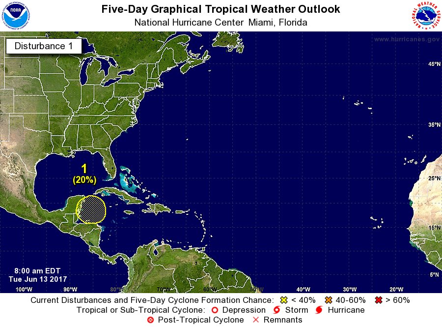
NHC has increased the potential for tropical cyclone formation around the Yucatan over the next 5 days to 50%.

Tropical system possible in the Gulf of Mexico late this weekend/early next week

A complicated pattern will evolve across the western Caribbean Sea and southern Gulf of Mexico this weekend which may give rise to the formation of a tropical storm in the Gulf of Mexico by late this weekend or early next week. A tropical wave currently moving through the Caribbean Sea will arrive into the western Caribbean Sea early this weekend while a northward lifting trough off the coast of Panama will interact with this wave. Convection has been increasing over much of the western Caribbean Sea over the last 24 hours and expect a continued increase in thunderstorm develop as these two features interact.

Model agreement from the ECWMF, GFS, CMC, UKMET, and many of the ensemble members show the formation of a very large surface low around the Yucatan over the weekend. While it is certainly possible for such a large surface low to develop into a tropical system, they tend to be very slow in doing so due to the massive size. What tends to be more common is that vorticity centers will rotate around the average low position and can sometimes become the dominate circulation center which can cause a plethora of forecast issues. Overall the organization of such a system takes longer than normal and can remain a disorganized mess. Several Gulf systems have developed this way and the main important feature from a system like this is to spread out the impacts over a wide area.

While the land interaction of the Yucatan will play some role in how this system develops and likely when, the overall model consensus and large size of the system should be able to overcome the interaction with the Yucatan. There is certainly enough support to have some confidence that a tropical depression or tropical storm will be forming in the south/south-central Gulf of Mexico by late this weekend.

The track of any developing tropical system will hinge on the ridge axis across the SW US and how far east that ridge axis may extend into TX. Additionally, the position of the mid and upper level ridge across the southern plains and where/how strong a weakness in this ridge over the W/NW Gulf by early next week. Models have been trending toward a ridge axis further to the north than previously expected along with the formation of an upper level weakness over the western Gulf of Mexico. This would likely help to bring any S/SC Gulf tropical system toward the WNW/NW into the western or northwestern Gulf of Mexico. It should be noted that some of the model guidance brings a stronger system more quickly northward toward the central and eastern US Gulf coast caught in the tail end of a trough over the Great Lakes. This solution appears less likely given the fact that the developing system will likely be disorganized and not as strong as those models are forecasting.

Most confident solution at this time is to bring a tropical depression/tropical storm away from the NW coast of the Yucatan Sun/Mon on a WNW motion and into the SC Gulf of MX Tues/Wed and then into the W Gulf of MX by the end of next week. A large mass of potential tropical storm force winds may cover much of the central Gulf of Mexico by the middle of next week.

Points of Interest:

o Actual formation of the surface center may be key to trackbut may not be as important as with other systemsgiven the very large size
o Large size of the system will have far reaching impacts
o Land interaction will complicate development over the weekend
o Track is still uncertain

Possible TX Impacts:

It is too early to be certain of any impacts along the TX coast given the uncertainty in the track forecast and what shape the system gradually develops into. Following the WNW track coordinated by NHC and WPC overnight into the western Gulf of Mexico middle to late next week would bring some degree of impacts toward the TX coast.

o Seas will likely begin to respond as early as Tuesday especially if the large mass of TS force winds forms across the northern semi-circle of the system
o As seas increase so may tides as more water is brought toward the coast in larger swells. Additionally winds will back to a more ESE/E direction across the northern Gulf which is a favorable tidal increase direction for the TX coast
o At some point could see a significant increase in moisture into TX if the center reaches the western Gulf allowing deep ESE flow through the column to transport copious moisture toward the coast.

Impacts, if any, will continue to be defined and clarified over the coming days.

Residents along the Gulf coast should closely monitor the progress of this system. Now is the time to make sure hurricane preparation plans and kits are fully stocked and in place.

carpe vinum
How long do you want to ignore this user?
AG
Steering mechanisms models are firming up on a western gulf storm.
This time of year they seem to usually push across mexico or form and squirt up to florida.
South Texas might get a little rain this time next week.
Brush Country Ag
How long do you want to ignore this user?
AG
carpe vinum said:

Steering mechanisms models are firming up on a western gulf storm.
This time of year they seem to usually push across mexico or form and squirt up to florida.
South Texas might get a little rain this time next week.
I could handle that...rain that is !
FishingAggie
How long do you want to ignore this user?
One. The one that hits corpus. That's the one that matters ( To me )
Brush Country Ag
How long do you want to ignore this user?
AG
FishingAggie said:

One. The one that hits corpus. That's the one that matters ( To me )
Me, too !
carpe vinum
How long do you want to ignore this user?
AG
Don't get too excited.
This far out there tends to be a helluva lot of "wobble" to model tracks.
Expect them to wobble back and forth between mexico and florida in the coming days, but at present south texas is looking almost favorable.
carpe vinum
How long do you want to ignore this user?
AG
As things play out I'm sure our actual Meteorologists on the board will chime in with far more accurate opinions.
carpe vinum
How long do you want to ignore this user?
AG
Levi at tropical tidbits finally released a new podcast.

Honestly, I have no idea of his bona fides, but he has come across as intelligent and more right than most that will actually go out on a limb to say something.

http://www.tropicaltidbits.com/blog/2017/06/16/watching-disturbed-weather-in-the-caribbean-and-gulf-of-mexico-next-week/
Brush Country Ag
How long do you want to ignore this user?
AG
According to Dale Nelson, ch 6, in Corpus tonight, a major High is building over S Texas from now until late next week. Hot as hell, but will push the tropical system away from S Texas .
Ag83
How long do you want to ignore this user?
AG
carpe vinum said:

Levi at tropical tidbits finally released a new podcast.

Honestly, I have no idea of his bona fides, but he has come across as intelligent and more right than most that will actually go out on a limb to say something.

http://www.tropicaltidbits.com/blog/2017/06/16/watching-disturbed-weather-in-the-caribbean-and-gulf-of-mexico-next-week/
Next to the NHC, this is who I listen to the most. Levi knows his stuff.
aggie4231
How long do you want to ignore this user?
AG
I followed him when he was first getting into meteorology and tropical storms on the wunderground blogs. He was pretty intelligent for a high school kid. I know several years ago he started college(probably has his B.S. by now). I think he even started his sight when he started college.

I trust him and Dr Jeff Masters (started wunderground). Masters used take part in the Hurricane Hunter flights until I think the late 80's, when he went through a near death flight through a storm.
Last Page
Page 1 of 106
 
×
subscribe Verify your student status
See Subscription Benefits
Trial only available to users who have never subscribed or participated in a previous trial.