

I10 underwater where?
Rain is outdoors.....
1,305,569 Views |
7087 Replies |
Last: 6 days ago by ABATTBQ87
Somerville appears to be dropping now 259.78...259.92 appears to be the crest.
Glad Somerville is dropping!
Where's that from.
Hopefully they can get it empty and at least some of the ramps open again but I'm not holding my breath for it to happen before the end of the summer again
Hopefully they can get it empty and at least some of the ramps open again but I'm not holding my breath for it to happen before the end of the summer again
Welch.
quote:
Valley lodge is completely under. Everyone down my way stayed and so far is ok but it is 'exciting' to say the least. The water is so deep and fast in places it is pulling up roads and impassable. At one point 290, i10, 1489, 1458 and 1093 all under deep fast water and closed.
The current has shifted over at Allen's Creek on FM 1458. Flowing back into the river. Usually a first sign of a crest.
Damn, I am supposed to play in a golf tournament benefitting ALS at the Wilderness in LJ on Friday. Last year's had to be rescheduled for the same reason.
I know a lot of folks that will be playing in that tourney. I would plan on it being postponed. Wilderness is only a mile from the river and already in a low area.
Apparently some areas of Rosenberg are under mandatory evac now,
Welcome to the memorial day festivities in simonton texas. Activities include emergency property valuation and prioritization, extreme powerlifting and cross training, mudwrestling, snake shooting, whitewater rafting, cattle rustling, goat herding, cat herding, horse loading, advanced team building, extreme automotive river crossings, competetive trailer loading and hauling, team sandbagging, advanced floating fireant hive avoidance dance lessons, spider dodging, competetive small engine repair, a chronic sleep deprivation study, and live 24 hour disaster footage, all in one lovely place.
Coming soon to rosenburg, richmond, rosharon, and other points of interest alomg the brazos.
It aint the height of the water that bothers you folks, its the velocity it picks up when it gets that deep.
If you live downriver, this is a totally different experience than anything since 1913. Not even the same kind of event as 2015.
quote:By all the river graphs, simomton should have started receding 24 hours ago, but as of sunset last night it was still rising. Something is very wrong with the models on this one.quote:
Valley lodge is completely under. Everyone down my way stayed and so far is ok but it is 'exciting' to say the least. The water is so deep and fast in places it is pulling up roads and impassable. At one point 290, i10, 1489, 1458 and 1093 all under deep fast water and closed.
The current has shifted over at Allen's Creek on FM 1458. Flowing back into the river. Usually a first sign of a crest.
Pouring in nw San Antonio.
Started yesterday morning.
River at 90 in Richmond is at 50.79, historic high was 50.3, still supposed to get 3 feet higher.
River at 90 in Richmond is at 50.79, historic high was 50.3, still supposed to get 3 feet higher.
Forecast for SA/NB/Austin includes several more inches in the next few days.
We are seeing the same thing.
Nm
I have to drive over the river on 723 tomorrow (might also go today to grab some stuff from lowes that I need). I'll post any pictures I can take while driving when I get back.
What we are thinking is that the river must have jumped another bank near Simonton or farther down, causing the current to shift. Only way it makes sense for water to flow that way, but then again we have never seen it this high.
Get it now. Better have and not need, than to need and not have.
It's canned light inserts for a small kitchen remodel. We can do without for a few days, if need be.
Still up over 2 feet from last night. All the usgs models were way wrong. Good chance that the Brazos river south of simonton will be going even higher than predicted, and topeaters possibly changing course in some ways. Its been at least 100 years sonce a flood this high so there may be some surprises.
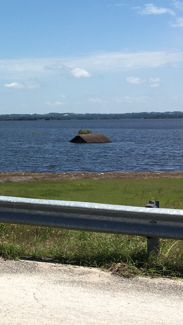
Our drone footage. We flew it from the bridge on 1458. That will help you get perspective. You can see the old highway that was washed out years ago. All that wooded pasture is ours as well as some of the fields.
Holy carp!
Average depth of that water is 7+ feet.
Just finished fertilizing all those hay fields 2 weeks ago.
Just finished fertilizing all those hay fields 2 weeks ago.
That sucks. I haven't seen anything quite that bad outside of archival footage of 1913.
I know it has been taboo to talk about...but we need a break in the rain. Too much, too often, too fast. The forecast this week is worrisome.
I know the drought sucked, but we need a dry month.
I know the drought sucked, but we need a dry month.
quote:Well, won't be a complete loss, and it's offset somewhat by the deep moisture that'll last a looong time. That's a good thing for deep rooted coastal. An annual sorghum-Sudan, not so much.
Average depth of that water is 7+ feet.
Just finished fertilizing all those hay fields 2 weeks ago.
quote:quote:Well, won't be a complete loss, and it's offset somewhat by the deep moisture that'll last a looong time. That's a good thing for deep rooted coastal. An annual sorghum-Sudan, not so much.
Average depth of that water is 7+ feet.
Just finished fertilizing all those hay fields 2 weeks ago.
It's complete loss in the sense that we lost all of the money for fertilizing Bermuda, we don't need any deep soil moisture with this being the 4th flood in 12 months, we will miss a second consecutive year in hay production, and we are feeding every hay reserve we have in May/June to keep 100 head of cattle on 30 acres.
Sorry if I sound negative, but that deep soil moisture will be long gone before we can even get cows out there let alone utilize it in a production setting. Now we just get to deal with the hogs rushing out to soft soil and tear everything up again.
Edit: that came out harsh, we are grateful to have every animal in a safe pasture, and not to lose animals like last year. And the fresh topsoil is by far the best benefit. There are some upsides, but when the work is done all you can do is watch.
Saw yesterday that the Guadalupe I. Guadalupe state park was expected to rise 30 feet.

Of course, all things considered, it's a big net loss. Didn't mean to minimize it.
I have the upmost respect for farmers n ranchers.
I have the upmost respect for farmers n ranchers.
quote:
Our drone footage. We flew it from the bridge on 1458. That will help you get perspective. You can see the old highway that was washed out years ago. All that wooded pasture is ours as well as some of the fields.
Thanks for posting. If theres anyway to get the simonton loop from the 1093 bridge that would be really be appreciated. .
How do you post youtube links?
I am uploading my video of the brazos at 723 now.
I am uploading my video of the brazos at 723 now.
Featured Stories
See All
9:58
2h ago
2.1k
SEC basketball midseason power rankings, superlatives & more
by Luke Evangelist
Pass-catcher Will Hargett to continue family legacy at Texas A&M
by Olin Buchanan
7:16
4h ago
954
12:06
1d ago
1.7k