Outdoors
Sponsored by

Rain is outdoors.....

1,305,234 Views | 7087 Replies | Last: 6 days ago by ABATTBQ87
XpressAg09
How long do you want to ignore this user?
AG
Flew to Navasota yesterday to check out the Brazos Navasota River. Hasn't rained in a couple days and it's still nasty. I initially went for the Brazos, but the airport was surprisingly busy and could only get pics of the Navasota.
The actual river is going horizontal about halfway up the propellor

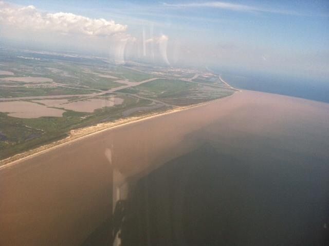
I don't think the river is in this picture, but don't recall...this could be just flooding

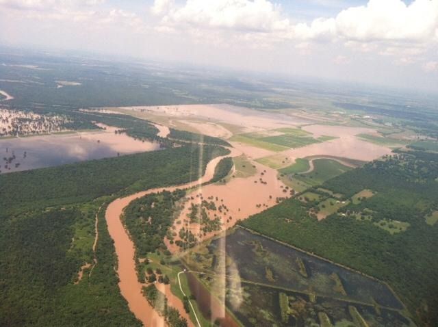
You can see the river going north/south and banking to the right in this picture.
schmellba99
How long do you want to ignore this user?
AG
Yep, the bottomlands of the Navasota flood fairly easily. And I think the river is in the second pic - you can see a snaking channel in the middle of the pic (or at least I can see what I think is one anyway).

Cool pictures, probably even better flying.
B-1 83
How long do you want to ignore this user?
AG
quote:
quote:
quote:
quote:
Texas Lake Levels

This is a much better website for lake levels, it updates every hour and some lake more than that.
I noticed Stillhouse has a ways to go, but Belton is creeping towards max capacity (but that last few feet is a huge amount of water on that lake). The Brazos sure doesn't need all that water from the Leon coming down.
And Belton just keeps coming up. My dad said the Leon is still out of banks in our river bottom. Stillhouse made a big jump.


What part of the Leon? My dad has been sending me photos if the Leon being out of banks as well.
Leon Junction - between Gatesville and the lake
Aggie_3
How long do you want to ignore this user?
quote:
quote:
I would tell your friends to make sure they review their policies, because it sounds like their insurance is trying to give them the run around. Sounds like it, my opinion without knowing a single detail.


There's no reason for an insurance company to give folks the run around.. Flood is through FEMA if they purchased a flood policy... Very few companies (none of the big ones) across country cover any type of flooding and when they do it isn't much.. As for the wind/tornado claim, they need to check policy. Their main insurance carrier (All State, State Farm, Farmers, etc ) probably told them they didn't cover it because they are in one of the coastal zones where they're required to go through TWIA.. If not they probably bought some cheap policy without doing any research and deserve whatever lack of coverage they are getting..
State farm does not require an extra wind policy anywhere in the state of Texas. We just don't write in most of the coastal areas
Aggie_3
How long do you want to ignore this user?
quote:
My wife was telling me that she has heard from some of our neighbors (in NW Houston) that got flooding and tried to file a claim under their flood insurance policy and are getting the run around with the adjuster saying some line about it being wind driven water damage and not flood driven so it isn't covered under their FEMA policy.
They need to raise all hell the winds in that storm weren't high enough for it to be considered wind driven. wind driven normally doesn't happen until you have hurricane type winds.
TJJackson
How long do you want to ignore this user?
Small world, my dad is in the process of moving from Gatesville out to Leon Junction
BlackGoldAg2011
How long do you want to ignore this user?
AG
Yea, i'd be pretty pissed, considering there were like 3 downed limbs in the whole neighborhood and i have picture evidence that water was deep enough in the street to almost be coming over the hoods of cars. I haven't heard any updates lately but I can't imagine any of those initial refusals will stand up for very long. Just thought it was ridiculous they even tried to claim that.
Ducks4brkfast
How long do you want to ignore this user?
AG
Chazz03
How long do you want to ignore this user?
AG
That California stat proves again how much their water system sucks
Lt. Joe Bookman
How long do you want to ignore this user?
AG
quote:
That California stat proves again how much their water system sucks
Yep. That is dumb.
Aggie_3
How long do you want to ignore this user?
quote:
Yea, i'd be pretty pissed, considering there were like 3 downed limbs in the whole neighborhood and i have picture evidence that water was deep enough in the street to almost be coming over the hoods of cars. I haven't heard any updates lately but I can't imagine any of those initial refusals will stand up for very long. Just thought it was ridiculous they even tried to claim that.
our experience the last two weeks dealing with fema is sometimes you get someone smart then the next call you get someone who is downright stupid. and we have dealt with them a lot being over here in Bulverde just south of blanco. they've been dragging their feet where as our adjusters have already gotten all of our wind damage claims done and dusted and the customers are getting repairs underway.
CrossBowAg99
How long do you want to ignore this user?
AG
I had to go to southern Brazoria county this morning

Apparently FM 1462 is closed at the Brazos

Here is a pic of the Brazos at FM 521


Brazos at FM 2004

schmellba99
How long do you want to ignore this user?
AG
You had me scratching my head wondering where 521 crosses the Brazos - dawned on me that 521 and 332 merge at Brazoria where the just built the new interchange and bridge.
CrossBowAg99
How long do you want to ignore this user?
AG
Yeah, that new bridge is way above the river.

carpe vinum
How long do you want to ignore this user?
AG
I've seen 2004 under water for miles.
drred4
How long do you want to ignore this user?
quote:
Somerville is over the spill way and is releasing 850cfs. That's a lot more water coming into the system still as well. I wish there was one boat ramp still open. It would have been neat to see in person.

You can see it in person. Just drive up to the place by the gates where everyone parks to fish. Or on the Overlook side their is an area where you can park as well and get out and look.

I was their yesterday at 5pm and it was barely going over. nothing like 1992 yet.
MGS
How long do you want to ignore this user?
quote:


Doesn't the "cover the entire state in 8 inches of water" stat just mean that there was 8" of rain on average in Texas?
CanyonAg77
How long do you want to ignore this user?
AG
quote:
quote:


Doesn't the "cover the entire state in 8 inches of water" stat just mean that there was 8" of rain on average in Texas?
Well, 35 trillion galons would be 107.4 million acre feet. Texas is about 172 million acres. So 107.4/172= .624 acre feet spread over the whole state, or 7.49 inches
techno-ag
How long do you want to ignore this user?
AG
quote:
quote:
quote:


Doesn't the "cover the entire state in 8 inches of water" stat just mean that there was 8" of rain on average in Texas?
Well, 35 trillion galons would be 107.4 million acre feet. Texas is 171.079 million acres. So 107.4/171.079 = .628 acre feet spread over the whole state, or 7.53 inches
So, basically, yes.
OE_Ag11
How long do you want to ignore this user?
AG
I thought in 92 it was at 258.6 last I saw it was at 258.3 I guess that last couple of inches makes a difference. I was more thinking though seeing some of the islands back in the back we normally tube and board behind. I bet my normal markers are all underwater so it would look completely different
Caliber
How long do you want to ignore this user?
AG
Somerville Peaked at 259.6' in 92...

OE_Ag11
How long do you want to ignore this user?
AG
Whoops yup another foot. That would be a heck of a lot more flow with how wide that spillway is.
carpe vinum
How long do you want to ignore this user?
AG
A new tropical storm is staying close to the Mexican coast heading generally toward Cabo. That could end up streaming a lot of moisture our way in a week or so.
Kenneth_2003
How long do you want to ignore this user?
AG
1250 ft wide if memory serves correctly...
ilikeit
How long do you want to ignore this user?
quote:
I've seen 2004 under water for miles


FM 2004 goes along way. From Brazoria to Hiway 6, which area have you seen under water?
I have lived in Brazoria for over 35 years and cant remember it over the road.
1939
How long do you want to ignore this user?
AG
Never mind.
carpe vinum
How long do you want to ignore this user?
AG
quote:
quote:
I've seen 2004 under water for miles


FM 2004 goes along way. From Brazoria to Hiway 6, which area have you seen under water?
I have lived in Brazoria for over 35 years and cant remember it over the road.
Sorry, not 2004, it was 2917 from 35 to 2004 back in the mid 80s after Claudette dumped about 2 feet of rain on that area.
schmellba99
How long do you want to ignore this user?
AG
quote:
quote:
I've seen 2004 under water for miles


FM 2004 goes along way. From Brazoria to Hiway 6, which area have you seen under water?
I have lived in Brazoria for over 35 years and cant remember it over the road.


I have seen it under water at CR 400 multiple times, and closer to Chocolate Bayou it has been under water more than once as well


Talking about 2004
carpe vinum
How long do you want to ignore this user?
AG
We had a summer house on Chocolate Bayou for many years. For Claudette we drove from BCS to board it up then shagged it back, afterward our normal path was blocked and we took a big 4WD the length of 2917 in 1-2 feet of water. Really creepy to look either side and see 100s of yards of water both sides. Like driving through a lake. Just glad they had road markers sticking up on either side.
carpe vinum
How long do you want to ignore this user?
AG
One thing to keep in mind this year, El Nino tends to generate homegrown Tropical Storms in the Gulf rather than long track storms. There will be less warning of storms this year.

Stive
How long do you want to ignore this user?
AG
Quick, someone warn Friendswood!!!!
Hunter_812
How long do you want to ignore this user?
AG
T&Ps for Friendswood
schmellba99
How long do you want to ignore this user?
AG
1462 opened up briefly from 521 heading west yesterday, but just saw that the County reinstalled the barricades at 521 and is not even letting residents in due to flooding from the Brazos and Oyster creek. Crest for the Brazos is expected to be something like 51.38', maybe hitting that crest late today or tomorrow, with a slow decline from that point on (barring any additional rain).
VanZandt92
How long do you want to ignore this user?
quote:
We had a summer house on Chocolate Bayou for many years. For Claudette we drove from BCS to board it up then shagged it back, afterward our normal path was blocked and we took a big 4WD the length of 2917 in 1-2 feet of water. Really creepy to look either side and see 100s of yards of water both sides. Like driving through a lake. Just glad they had road markers sticking up on either side.


Pics?
schmellba99
How long do you want to ignore this user?
AG
Some pics that were posted on Facebook of the mouth of the Brazos:

Mouth of the Brazos showing the insane amount of silt being pushed down the channel and into the Gulf:


This is from just west of Cow Trap and Cedar Lakes looking east towards the mouth of the new channel. You can see the San Bernard (it's closed again, has been for a while now) in the middle of the picture with the Brazos towards the top at the color change:


This one is from roughly right above FM 1462 looking more or less northeast. The reservior you see in the bottom right is Turner Lake and Brazos Bend SP is on the left hand side of the river. The flooded farm land is Darrington Prison.
First Page Last Page
Page 43 of 203
 
×
subscribe Verify your student status
See Subscription Benefits
Trial only available to users who have never subscribed or participated in a previous trial.