In some of the other threads that have arisen recently about various public policy issues, there are inevitably posters who make the argument that Houston should essentially not deal with any other issue until all of the streets in Houston have been repaired. I was thinking it might be good and/or fun to share some information about our streets, their condition, and efforts that are underway to make repairs.
Contrary to what some may think, Houston has a government that is indeed capable of handling more than one issue at a time, and even though there may be robust debate and discussion on various issues of public policy, repair and reconstruction of streets is an ongoing-effort. In fact, the Capital Improvement Program budget is going to go before City Council in the next month. This will be the time when City Council approves all of the street repairs and reconstruction for the next five years.
So yes, our government is, in fact, actively engaged in addressing the problems with our streets.
In 2010 voters approved a Charter amendment that required the City to move away from debt-funded street and drainage projects and into a pay-as-you-go funding system. What that means is the City cannot add new debt, but must continue to pay down the existing debt on the books. As the existing debt gets paid down with ad valorem tax renevue, the interest savings gets converted to additional cash funding for projects. For example, is we have $1 billion in debt and we pay it down to $950 million, we spend the $50 million delta on more projects.
The City currently has about $1.7 billion in debt as a result of bond obligations for street and drainage projects and pays roughly $150 million per year in interest on that debt. As we pay it down, this is what the big picture looks like:

Needless to say, the transition from debt-funding to pay-as-you-go is a bit slow in these early years, but begins to accelerate as we reduce debt.
Now let's take a look at the reality of the situation with regard to the condition of our streets. Houston has approximately 16,500 lane miles of roadway. That's a LOT of damn roadway. We invested in a state of the art pavement assesment vehicle several years ago that is able to provide scientifically objective measurable data about the condition of our roadways. It seemed like everyone in the City was convinced the streets they drive on are the worst in the entire city, so the City had to come up with an objective means, and the pavement assessment vehicle has worked extremely well.
After driving every single lane mile in the City, the vehicle provides data that allows for the assignment of a condition rating to each roadway, with roadways often being split up into many smaller segments with different ratings. Those ratings then allow for roadways to be assigned a priority for reconstruction or major repairs (as opposed to overlays or minor repairs). The map below shows the priority of every street in the city. Yellow is low priority, orange is medium, and red is high.
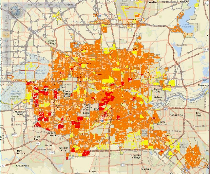
The number of streets that have moved from low to medium has increased in recent years. The number of streets that need repair greatly exceeds the ability of the City to pay for such repair. The one thing I always try to gently inform people is that no matter how bad they think their streets are, someone else has it worse. That doesn't mean there isn't a need, it just means that the City's need to address the worst streets first means someone else's street will probably come first.
I know, it's a bleak picture.
So what do we have lined up for actual projects? The map below shows all of the current projects. These projects are in various stages - some are under construction, others are in the engineering phase, and some are programmed on the books waiting to start. Dark green lines are major thoroughfare construction; light green areas are local street projects.
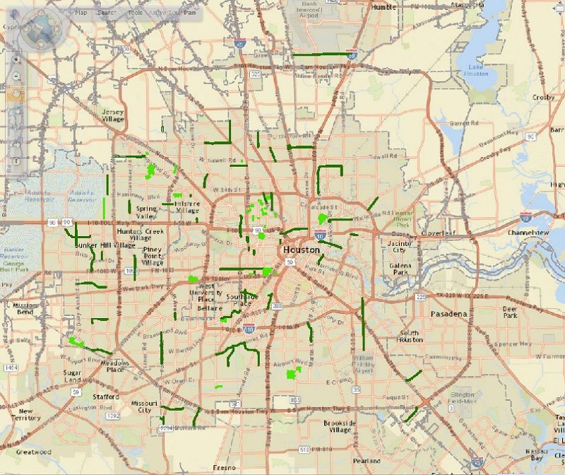
Looks disappointing, right? That map actually represents $767 million in projects. (the link gives you a breakdown of every project)
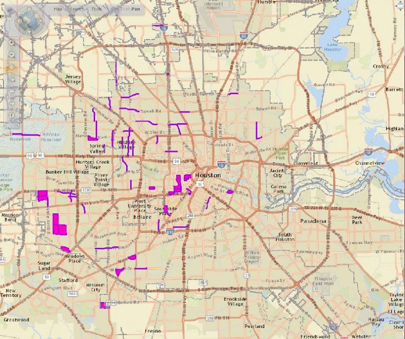
Since we know what is on the books for the next five year, we can also look an additional five years out to identify areas that should be strongly considered for programming. Purple lines are major thoroughfares; pink areas are local streets.
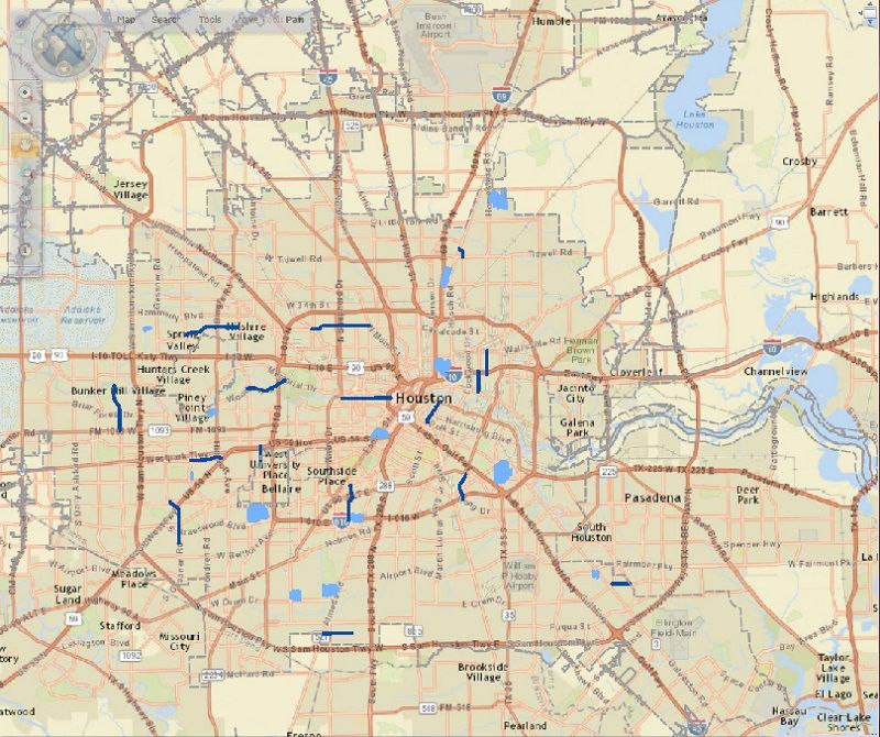
In addition to programmed projects and projects for consideration, we also have projects that have been engineered but are not yet programmed due to a lack of funding. These are what people typically call "shovel-ready" projects. Dark blue lines are major thoroughfare projects; light blue areas are local street projects.
So there you have it, a pretty basic overview of what is going on with our streets.
[This message has been edited by Ryan the Temp (edited 6/17/2014 10:31a).]
Contrary to what some may think, Houston has a government that is indeed capable of handling more than one issue at a time, and even though there may be robust debate and discussion on various issues of public policy, repair and reconstruction of streets is an ongoing-effort. In fact, the Capital Improvement Program budget is going to go before City Council in the next month. This will be the time when City Council approves all of the street repairs and reconstruction for the next five years.
So yes, our government is, in fact, actively engaged in addressing the problems with our streets.
In 2010 voters approved a Charter amendment that required the City to move away from debt-funded street and drainage projects and into a pay-as-you-go funding system. What that means is the City cannot add new debt, but must continue to pay down the existing debt on the books. As the existing debt gets paid down with ad valorem tax renevue, the interest savings gets converted to additional cash funding for projects. For example, is we have $1 billion in debt and we pay it down to $950 million, we spend the $50 million delta on more projects.
The City currently has about $1.7 billion in debt as a result of bond obligations for street and drainage projects and pays roughly $150 million per year in interest on that debt. As we pay it down, this is what the big picture looks like:

Needless to say, the transition from debt-funding to pay-as-you-go is a bit slow in these early years, but begins to accelerate as we reduce debt.
Now let's take a look at the reality of the situation with regard to the condition of our streets. Houston has approximately 16,500 lane miles of roadway. That's a LOT of damn roadway. We invested in a state of the art pavement assesment vehicle several years ago that is able to provide scientifically objective measurable data about the condition of our roadways. It seemed like everyone in the City was convinced the streets they drive on are the worst in the entire city, so the City had to come up with an objective means, and the pavement assessment vehicle has worked extremely well.
After driving every single lane mile in the City, the vehicle provides data that allows for the assignment of a condition rating to each roadway, with roadways often being split up into many smaller segments with different ratings. Those ratings then allow for roadways to be assigned a priority for reconstruction or major repairs (as opposed to overlays or minor repairs). The map below shows the priority of every street in the city. Yellow is low priority, orange is medium, and red is high.

The number of streets that have moved from low to medium has increased in recent years. The number of streets that need repair greatly exceeds the ability of the City to pay for such repair. The one thing I always try to gently inform people is that no matter how bad they think their streets are, someone else has it worse. That doesn't mean there isn't a need, it just means that the City's need to address the worst streets first means someone else's street will probably come first.
I know, it's a bleak picture.
So what do we have lined up for actual projects? The map below shows all of the current projects. These projects are in various stages - some are under construction, others are in the engineering phase, and some are programmed on the books waiting to start. Dark green lines are major thoroughfare construction; light green areas are local street projects.

Looks disappointing, right? That map actually represents $767 million in projects. (the link gives you a breakdown of every project)
Since we know what is on the books for the next five year, we can also look an additional five years out to identify areas that should be strongly considered for programming. Purple lines are major thoroughfares; pink areas are local streets.

In addition to programmed projects and projects for consideration, we also have projects that have been engineered but are not yet programmed due to a lack of funding. These are what people typically call "shovel-ready" projects. Dark blue lines are major thoroughfare projects; light blue areas are local street projects.

So there you have it, a pretty basic overview of what is going on with our streets.
[This message has been edited by Ryan the Temp (edited 6/17/2014 10:31a).]


