

Going to try for the first time this weekend. Anybody know some good spots?
Post Reply
1 of 1
Wade fishing around Corpus Christi
7,630 Views |
18 Replies |
Last: 12 yr ago by sunchaser
Surf down from Bob Hall pier has always been good with live mullet for reds and trout or dead shrimp past the 3rd bar for Pompano and whiting.
Wilson's Cut.
....don't leave anything of value in your vehicle.
I second Wilson's cut. Steadmans reef is a good spot as well.
Where specifically at Wilson's cut? On the map it looks like a kayak launch w/ a channel, is this the right place?
If you have a kayak then Wilson's Cut. Take the dirt road on the south side of the channel as far as you can go down until you get to a gate and park off to the side. Go directly north across the channel to some large flats and fish the potholes.
If you don't have a kayak then you can still get there but it is a hard wade and you should take the dirt road to the north as far as you can so you don't have to swim the channel.
Heard of brown tide last weekend, not sure if that is still going on, if so you will have better luck in the surf or the packery jetties. If you do take that wade at Wilson's Cut, watch for stingrays in those flats.
Also, there is a hole not far from Fish Pass called Kate's hole. You can wade that far if no kayak.
http://www.stxmaps.com/go/kates-hole.html
And you do have the right spot on the map.
Hit Brown & Root flats early with topwaters.
How do you wade into B&R?
Dbl post
[This message has been edited by sunchaser (edited 6/3/2013 11:02a).]
[This message has been edited by sunchaser (edited 6/3/2013 11:02a).]
quote:
Heard of brown tide last weekend, not sure if that is still going on, if so you will have better luck in the surf or the packery jetties
I can confirm - 100% - that the water in the bays around Corpus looks awful. Terrible. Brown, yellow, golden. Anything but green and blue.
The water North of JFK, and on the south shoreline of CC Bay/Shamrock - brown.
The water South of JFG, Pita Island, Pure Oil channel, King Ranch Shoreline - all brown.
There are two places to find clean water around Corpus right now. First - the Packery Channel around the bridge where everyone stacks up. The other spot is 2 miles south of Baffin Bay. The water in Rocky Slough looks nice and we caught trout there yesterday. Once you get to Baffin - its all brown from there ALL the way up the intercoastal to CC Bay. Its nasty.
I heard salinity levels are real high in Baffin and CCB. Mix that with brown tide and there are no fish.
Gotta go South of Baffin for clean water. Land Cut looks good too, but there were not biting for us this weekend.
Something may have changed since I went there last, but here is how I used to get into Brown and Root flats without a boat. This is coming from Port A.
First ride the ferry and head towards Aransas Pass. Take your first left toward the causeway water after you leave the ferry area. As you pull in, you will see tracks off to the left. Follow these tracks and it will lead you on a long sand road and you will see flats off the the right. It is really shallow for a long way, so keep going until you see the ship channel on your left. At that point, the B&R flats are on your right and you can access good potholes and hopefully do well.
Do not try this at high tide, that road will be mostly covered by water and destroy your vehicle. Four wheel drive is a bonus also.
[This message has been edited by HillcountryAg97 (edited 6/3/2013 1:40p).]
Indian point/Sunset Lake area.
quote:
How do you wade into B&R?
We always parked between the ferry landing and the last bridge on the causeway. Trek through the mangroves and into the water. We would wade all the way to Sailboat Channel and back. Shallow, long wade. But more often than not, productive.
If you can get into it as Hill Country stated ie the sandy road that parallels the CC channel you are on the good side to wade IMO.
Shallow and can cast with the wind.
I normally go under the bridge....by boat...turn right and then left in the north/south channel. I think that is the way San Antone is talking about. That is a really long wade to get into what I call B&R.
If you look at a Google Earth map you can see a pipeline running nearlly the full length of B&R. It will normally be about knee deep plus. If you wade across it and step into a soft spot...lots of them... you might have to spit a little bit of water. It might be six inches deeper but the bottom is very soft. Lots of people will wade on the side of or pole that fish highway....
[This message has been edited by sunchaser (edited 6/3/2013 3:15p).]
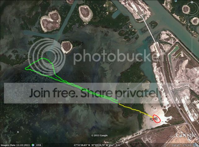
Sunchaser, here's how we used to do it.
Red=park
Yellow=trek through trail in mangroves.
Green=wade edge of pipeline whilst casting, make a loop to include edge of Sailboat and wade back.
Red=park
Yellow=trek through trail in mangroves.
Green=wade edge of pipeline whilst casting, make a loop to include edge of Sailboat and wade back.
That'll work.
If I were going to walk in tomorrow I would want to stay on that sand road and stop one mile west of 361. Wade in from there toward your loop. The first part of your wade is in beautiful water but I have historically seen more reds on the south shoreline. NW80 would get knee deep and wade straight west to that spoil dump on the east side of that cut.
If I were going to walk in tomorrow I would want to stay on that sand road and stop one mile west of 361. Wade in from there toward your loop. The first part of your wade is in beautiful water but I have historically seen more reds on the south shoreline. NW80 would get knee deep and wade straight west to that spoil dump on the east side of that cut.
Featured Stories
See All