
East of a line roughly from Sulphur Springs to Canton to Athens to the Trinity between Fairfield and Palestine and then follow the Trinity south - that's East Texas!
Do any of y'all consider B/CS as part of East Texas?
3,521 Views |
59 Replies |
Last: 4 days ago by vin1041
Some of the regions could use some adjustments but this is pretty close, and no BCS is not in East Texas.
Yeah, Conroe and the surrounding areas are much more East Texas than Gulf Coast.
I agree. Conroe is east Texas light with a growing Houston influence.
As someone who isn't from anywhere close to east texas, I'd say yes….its close enough
San Antonio should be hill country on that map for sure
The way they have the panhandle/west Texas categorized is laughable.
The way they have the panhandle/west Texas categorized is laughable.
I mean, he has a point.Mega Lops said:Jawn Dough said:
Geographically, yes.

When you look at Texas in "Sectors" rather than "Regions", the lines can really change your POV
I drew this Sector on top of a map of our state. It's roughly showing 12:15 and 4:20 "Clock" lines moving outwards from B/CS.

It does show that it's within the Eastern Texas Sector.
This is why I made this thread. There's a mild argument to be had.
SIDE NOTE: B/CS might actually be one of the most strategically positioned cities in the entire state.

No way is B/CS considered east Texas.
You can set off from College Station and go TO east Texas.
But nobody you've ever heard of would describe College Station as east Texas.
Kind of a red flag really. Someone describes BCS as east Texas you gotta keep an eye on that person for the sake of good order because they suspect.
You can set off from College Station and go TO east Texas.
But nobody you've ever heard of would describe College Station as east Texas.
Kind of a red flag really. Someone describes BCS as east Texas you gotta keep an eye on that person for the sake of good order because they suspect.
People from west of the Pecos consider BCS east Texas.
Most people west of Pecos need to get their clocks fixed and stop encouraging mountain nonsense. Texas is the center of the universe, that's why it's called the Central Time Zone.

keep up the trolling and enticing dorks to look at imaginary lines.LETTUCE PRAY said:I mean, he has a point.Mega Lops said:Jawn Dough said:
Geographically, yes.
When you look at Texas in "Sectors" rather than "Regions", the lines can really change your POV
I drew this Sector on top of a map of our state. It's roughly showing 12:15 and 4:20 "Clock" lines moving outwards from B/CS.
It does show that it's within the Eastern Texas Sector.
This is why I made this thread. There's a mild argument to be had.
SIDE NOTE: B/CS might actually be one of the most strategically positioned cities in the entire state.

Nope
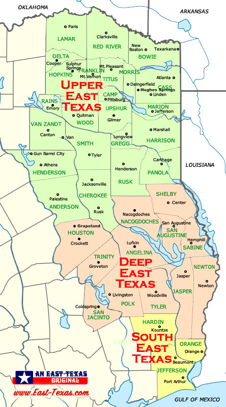
The pine trees in Bastrop are in no way, shape or form part of the pine curtain. Go east to Livingston and you'll see the curtain. Runs down to Kountze, and up to Paris.
People who call themselves East Texans don't think CS is in E Texas. People from parts West kinda do. The triangle of I35-I45 and I10 kinda delineates it as 'Central Texas'. If you drew a North South dividing line in the triangle, it would be in the Eastern part of Central Texas.
I think B/CS is very similar to East Texas culturally, though. A lot moreso than West Texas.
I think B/CS is very similar to East Texas culturally, though. A lot moreso than West Texas.
Greater love hath no man than this....
Max Power said:
Some of the regions could use some adjustments but this is pretty close, and no BCS is not in East Texas.
This is pretty good, but the panhandle damn sure doesn't cross I20.
And East Texas is east of I45, or maybe right along it in places.
Very close, but not exactly east texas.
Moreso than West Texas, yes. But really not very similar at all. East Texas is practically a different state.rwtxag83 said:
I think B/CS is very similar to East Texas culturally, though. A lot moreso than West Texas.
Hwy30East said:
East Texas is all east of IH45 in my book.
The most correctest answer so far
Hwy30East said:
East Texas is all east of IH45 in my book.
I-45 runs through my hometown and I grew up about 10 miles west of it... I agree with this.
While all of East Texas is east of 45, not everything east of 45 is East Texas.
Center = East Texas
Centerville /= East Texas
Center = East Texas
Centerville /= East Texas
No. I roughly use 45 as the line. Doesn't work perfectly the entire way (mainly near Houston and Dallas), but for where BCS sits, it does.
The Trinity River from about Corsicana south (I45 starts to far west) is a better line. West of the Trinity - almost no pines. East of the Trinity the pines start almost immediately. Canton on I20 is about where it starts.DannyDuberstein said:
No. I roughly use 45 as the line. Doesn't work perfectly the entire way (mainly near Houston and Dallas), but for where BCS sits, it does.
It's 200 miles from the Pecos River to the start of the Mountain Time Zone.Anchorhold said:
Most people west of Pecos need to get their clocks fixed and stop encouraging mountain nonsense. Texas is the center of the universe, that's why it's called the Central Time Zone.
No
Featured Stories
See All
No. 7 A&M seeks to respond vs. No. 6 Tennessee on Saturday morning
by Olin Buchanan
13:35
9h ago
2.5k
10:35
12h ago
948
Keys to the Game: No. 7 Texas A&M vs. No. 6 Tennessee
by Luke Evangelist
40:51
18h ago
2.7k
Bullpen Chias
BASEBALL: Saturday's Texas A&M-Cal Poly game moved to NOON
in Billy Liucci's TexAgs Premium
2