
I was just curious if anyone knew of or had any pictures of the Colorado River before it got dammed up by LCRA.
Post Reply
1 of 1
Pre-Dam Colorado River Pics?
2,350 Views |
9 Replies |
Last: 10 yr ago by Rabid Cougar
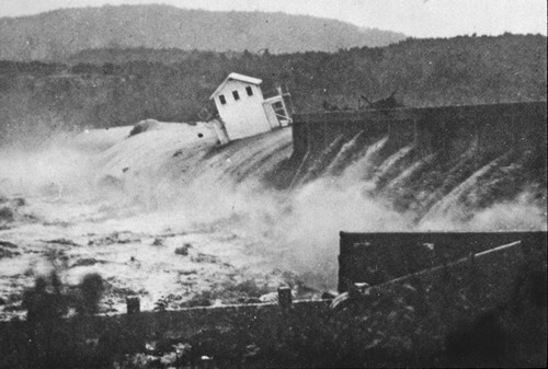
I have mental pictures - saw the Austin dam go down in 1935 and the Montopolis bridge go down.
Go to the Austin library site - believe they have all the pictures available at that time.
Go to the Austin library site - believe they have all the pictures available at that time.
Always like these pics...1935

Wow
It's crazy to believe that is possible when you see the current state of some of the Highland Lakes (i.e. Buchanan in particular)
My usual rec is earthexplorer.usgs.gov.
It requires a free login to initiate downloads. However that area doesnt seem to have any available aerials of that age.
The next best bet is probably the national archives. This can take a lot of research but there are tons of pre-war reconnaissance training missions that captured aerials of what at the time were very rural areas.
I assume above that you want vertical/mapping style photos.
Side note....if you can find aerials like I describe above they almost certainly will be unrectified and will have end lap and side lap appropriate for stereo viewing. Such images would be quite striking in that area.
^ great pics !!!!!!!!!!!!!!!!!!!!!!!!!!!!!!!!!!!!!!!!!!!!!!
Featured Stories
See All
3:58
3h ago
1.8k
13:34
1h ago
697
Bubble threatens to burst if Bucky Ball can't beat Ole Miss
by Olin Buchanan
11:51
15h ago
4.8k
Three freshmen homer in come-from-behind effort
by Richard Zane
5:13
2h ago
808
DaAggies
Devin Price back in the program to start coaching career
in Billy Liucci's TexAgs Premium
83
ReturnOfTheAg
Devin Price back in the program to start coaching career
in Billy Liucci's TexAgs Premium
40
coach mike
Devin Price back in the program to start coaching career
in Billy Liucci's TexAgs Premium
29
RAB87
FINAL from Blue Bell: No. 24 Texas A&M 8, Texas A&M-Corpus Christi 3
in Billy Liucci's TexAgs Premium
28
AggiePoot
Devin Price back in the program to start coaching career
in Billy Liucci's TexAgs Premium
28
Bulldog73
Devin Price back in the program to start coaching career
in Billy Liucci's TexAgs Premium
24