
Where exactly was the original train depot in downtown Bryan? Are there any pics?
Post Reply
1 of 1
Original Train Depot in Bryan
5,907 Views |
25 Replies |
Last: 13 yr ago by squirrelhunter
There have been several. The one I remember was approximately where the little park is with the fountain (Main between 28th & 29th). I think there was another one within a block or two of the same location. I don't remember any of them actually being in operation though, so I don't know.
I think originally there may have been two depots--one for the H&TC and one for the I&GN. As far as predecessors/successors to those roads, I don't know.
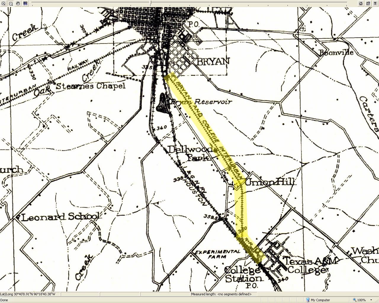
I'd also be interested in knowing where the stations were for the Bryan-College Interurban. I'm sure there was a station downtown but don't know where. And I believe there was a stop at Dellwood Park near Midway. The tracks turned toward Union Hill and went up Old College Road to College Main and then to the north gate. I kind of doubt any of the stops really had "stations" though.
I think originally there may have been two depots--one for the H&TC and one for the I&GN. As far as predecessors/successors to those roads, I don't know.
I'd also be interested in knowing where the stations were for the Bryan-College Interurban. I'm sure there was a station downtown but don't know where. And I believe there was a stop at Dellwood Park near Midway. The tracks turned toward Union Hill and went up Old College Road to College Main and then to the north gate. I kind of doubt any of the stops really had "stations" though.
According to the Sandborns in 1896:
1896 Key
Map 3
It's East of Main and south of what was then Anderson. (Which I believe is 26th St. now) Basically, the site of the public library. That would make some sense as Tabor Rd looks like it could follow the old rail bed for the depot siding... but that's a complete guess on my part.
1896 Key
Map 3
It's East of Main and south of what was then Anderson. (Which I believe is 26th St. now) Basically, the site of the public library. That would make some sense as Tabor Rd looks like it could follow the old rail bed for the depot siding... but that's a complete guess on my part.
This 1912 map has it located basically behind the Carnegie Library. Also on that map is the interurban "car barn"
I also found my friend's new house on Lamar (29th) Beautiful old place.
I also found my friend's new house on Lamar (29th) Beautiful old place.

I hate running across such beautiful buildings that are no longer with us.
Northeastern Depot:
Sorry, I'm running roughshod all over your thread, but I keep running into interesting stuff.
A very unique view of campus looking towards Bryan. I doesn't look like campus is connected by a road to Bryan at all in this photo, though I'm sure it was. (1929)
A very unique view of campus looking towards Bryan. I doesn't look like campus is connected by a road to Bryan at all in this photo, though I'm sure it was. (1929)
God, I need to go to bed.
A really good write up. And with that, I'm hitting the sack.
The one p_bubel posted as "Northeastern depot" looks like the one I was talking about. It's the only on I remember still standing in my lifetime.
The Ursuline Academy was near the current intersection of Villa Maria Road and Wm. Joel Bryan. It's approximately where Villa Maria turns into Ursuline. Both streets are named for the Academy. Incidentally, the reason it's pronounced "villa" and not "vee-yah" is that it's not Spanish it's Italian.
The Ursuline Academy was near the current intersection of Villa Maria Road and Wm. Joel Bryan. It's approximately where Villa Maria turns into Ursuline. Both streets are named for the Academy. Incidentally, the reason it's pronounced "villa" and not "vee-yah" is that it's not Spanish it's Italian.
Thanks for posting that article. A very interesting read. I learned several things that I had not heard before. (I do find it interesting, though, that it talks about a line across the Brazos to Smetana. Smetana is not across the river from Bryan.)
I found a reference to a station with the nickname of "Ginny" with a terribly useless photo, which does not look like the one I posted. I could see the G&N getting that nickname at some point... but I already posted a photo of that one. Weird.
I got tired though and crashed. Maybe later I'll go hunting for it again.
I got tired though and crashed. Maybe later I'll go hunting for it again.
Fascinating photo from 1929, p bubel.
Great photo p_bubel!

[This message has been edited by Old Main (edited 1/6/2012 4:59p).]
[This message has been edited by Old Main (edited 1/6/2012 4:59p).]
Hi Old Main and the rest! The "Northeast"station was the Missouri Pacific station. Plain white.
The original station was the Houston and Texas Central station. The town of Bryan moved to meet the railroad as I recall.
The location of the original Ursuline Academy is very near the UPS office. Back in the late 90's, there was a large field w/ old baseball backstops and a lot of concrete rubble in the area where I was told the academy was located. Near the field was a grove of trees in which was located couple of ponds and the remnants of some sort of concrete cistern that I assumed was a water source for the academy. I understand the academy later moved to where the women's prison is.
There is a marker near the location of Ursuline Academy. It's right next to the Voices for Children office.
The prison is on the former location of Allen Academy.
The prison is on the former location of Allen Academy.

You can barely make out the name at the top.


I guess the first one I posted was the freight depot.
[This message has been edited by p_bubel (edited 1/7/2012 5:00p).]
That's right, Eva. I had forgotten there was a second academy in that area. There were a couple of nice mansions next to the prison that I thought were once part of the academy. One was burned/demolished when I lived in that area. What a shame to see a grand old house like that come down.
Back in the day wasn't the depot or express office where freight came in and the station is where passengers came in?
The I&GN station in the postcard painting was located where there little park is now. If you look very close you will see a spur track coming directly into the bottom of the scene and a track that sharply curves off to the left. The curving track in the mainline out to Mumford and Valley Jct. The spur track is heading for the middle of Bryan Av for the trip down to the cotton industries. If you notice in the Sanborn maps there are numerous other industrial spurs off this tap.
Also if you look VERY close you can make out the old Tower 36 building at the crossing of the H&TC and the newly arrived I&GN (around 1900). This crossing is now gone and the surrounding trackage was realigned to create straight non-intersecting paths.
Also if you look VERY close you can make out the old Tower 36 building at the crossing of the H&TC and the newly arrived I&GN (around 1900). This crossing is now gone and the surrounding trackage was realigned to create straight non-intersecting paths.
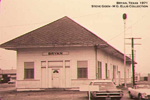
The Mark Thomas photo is of the old Missouri Pacific freight (? not sure on this but makes sense) depot that was located along Main just south of 29th street.
Folks interested in this topic might find this page useful.
http://centexrails.blogspot.com/2008/09/bryan-gateway-park-historical-momentos.html with it associated pictures from old Bryan and the railroad.
http://centexrails.blogspot.com/2008/09/bryan-gateway-park-historical-momentos.html with it associated pictures from old Bryan and the railroad.
Leonard, is that you?
the original I&GN deport looks nothing like the the freight depot? Did the MoPac tear it down after the last passenger trains were ended in the 60's?
the original I&GN deport looks nothing like the the freight depot? Did the MoPac tear it down after the last passenger trains were ended in the 60's?
Featured Stories
See All
LIVE from Reed Arena: Texas A&M vs. Oklahoma
by Luke Evangelist
Scrappers and warriors required as Texas A&M hosts Oklahoma
by Olin Buchanan
Keys to the Game: Texas A&M vs. Oklahoma
by Luke Evangelist
Friday (1/9) Portal Storylines: Weekend arrives in Aggieland
by TexAgs Recruiting
7:47
1d ago
2.2k
Hard-throwing RHP Clayton Freshcorn feels 'way stronger' entering '26
by Ryan Brauninger