Of course, there are many highways and backroads in Texas that were once the trails between the far-flung outposts of Texas, most notably portions of Hwy 21 and numerous backroads between SA & San Marcos as portions of the El Camino Real, along of course with TX OSR. One of history's mysteries to me is why a large portion of the original route of the Gonzales to Bexar road was completely abandoned. As in there is no trace of the sucker that I can tell between Bebe and the Cibolo creek.
I've found old maps showing the route within the deeded portions of Gonzales county, so that is pretty easy to trace. Present day Hwy 97 is probably a close representation of the route down through Cost and down to Bebe. This route avoids Five Mile creek and crosses the tributaries of the Salt Creek where they are small and flat.
Part of the land paid in kind to Byrd Lockhart for surveying duties was on the road, at the confluence of O'Neil and Sandies creek SW of present day Leesville (I also know the landowners today, as probably does everyone else in Gonzales Co.) Up until this point it is pretty clear where the overall route was.

Where it goes after that is a little sketchy. I have found accounts of a "Forty Mile Hole" on a branch of the Ecleto Creek on the road. Teran described this part of the road through the post-oak sandhills of (now) Guadalupe or Wilson county as high, desolate, sandy and pretty miserable. This in no doubt contributed to alternate routes on the "high road" that crossed the San Marcos outside Gonzales and went in the general direction of Seguin, crossing the Guadalupe evidently around the confluence with Mill Creek.
From a hole on a branch of the Ecleto, I found a reference in this link http://alamostudies.proboards.com/index.cgi?board=texasrev&action=display&thread=142 where the route crossed the Cibolo below Martinez creek. That would put it near the current Zuhl crossing just outside St. Hedwig. I always assumed that the road from St. Hedwig (FM 1346) that turns into Houston & Commerce Street (Alameda St. back then).
I did find a reference that the Gonzales road is actually closer to Rigsby in crossing the Salado Creek (where they fought prior to the siege of Bexar):

That's actually a bit further south than I expected, tracing Commerce/Houston street beyond downtown. If I recall correctly, there was an illustration in one of the Hardin Books that had an illustration of old San Antonio... I'll have to look for that one.
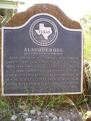
This image shows the road running approximately from the Alamo to Gonzales:

It is likely that there were several crossings from Bexar to the road, depending on how the conditions were you may have had to detour to the Rigsby crossing that evidently was shared with the La Bahia road.
This still leaves a vast stretch of the road (between Bebe & St. Hedwig) that was completely abandoned at some point in time. The route was likely inhospitable to horse and wagon traffic, as it was largely sandy and probably with unreliable water, although the creeks back in those days had less brush and higher rainfall to work with and likely flowed year round, or at least had water in holes. It's not unlike any other road in Texas at that time, though.
Perhaps the lack of settlement is what induced people to travel the route near Mill Creek initially, and that then got pushed even more indirectly once Walnut Springs/Seguin became established.
It is interesting that with the advent of motor vehicle traffic the route was never resurrected. Until the completion of Hwy 90, I understand the driving route to San Antonio was through Seguin to New Berlin, rather than any direct route south of the Guadalupe.
If anyone has a book or map they can recommend, I would be very interested.
I've found old maps showing the route within the deeded portions of Gonzales county, so that is pretty easy to trace. Present day Hwy 97 is probably a close representation of the route down through Cost and down to Bebe. This route avoids Five Mile creek and crosses the tributaries of the Salt Creek where they are small and flat.
Part of the land paid in kind to Byrd Lockhart for surveying duties was on the road, at the confluence of O'Neil and Sandies creek SW of present day Leesville (I also know the landowners today, as probably does everyone else in Gonzales Co.) Up until this point it is pretty clear where the overall route was.
Where it goes after that is a little sketchy. I have found accounts of a "Forty Mile Hole" on a branch of the Ecleto Creek on the road. Teran described this part of the road through the post-oak sandhills of (now) Guadalupe or Wilson county as high, desolate, sandy and pretty miserable. This in no doubt contributed to alternate routes on the "high road" that crossed the San Marcos outside Gonzales and went in the general direction of Seguin, crossing the Guadalupe evidently around the confluence with Mill Creek.
From a hole on a branch of the Ecleto, I found a reference in this link http://alamostudies.proboards.com/index.cgi?board=texasrev&action=display&thread=142 where the route crossed the Cibolo below Martinez creek. That would put it near the current Zuhl crossing just outside St. Hedwig. I always assumed that the road from St. Hedwig (FM 1346) that turns into Houston & Commerce Street (Alameda St. back then).
I did find a reference that the Gonzales road is actually closer to Rigsby in crossing the Salado Creek (where they fought prior to the siege of Bexar):
That's actually a bit further south than I expected, tracing Commerce/Houston street beyond downtown. If I recall correctly, there was an illustration in one of the Hardin Books that had an illustration of old San Antonio... I'll have to look for that one.
This image shows the road running approximately from the Alamo to Gonzales:
It is likely that there were several crossings from Bexar to the road, depending on how the conditions were you may have had to detour to the Rigsby crossing that evidently was shared with the La Bahia road.
This still leaves a vast stretch of the road (between Bebe & St. Hedwig) that was completely abandoned at some point in time. The route was likely inhospitable to horse and wagon traffic, as it was largely sandy and probably with unreliable water, although the creeks back in those days had less brush and higher rainfall to work with and likely flowed year round, or at least had water in holes. It's not unlike any other road in Texas at that time, though.
Perhaps the lack of settlement is what induced people to travel the route near Mill Creek initially, and that then got pushed even more indirectly once Walnut Springs/Seguin became established.
It is interesting that with the advent of motor vehicle traffic the route was never resurrected. Until the completion of Hwy 90, I understand the driving route to San Antonio was through Seguin to New Berlin, rather than any direct route south of the Guadalupe.
If anyone has a book or map they can recommend, I would be very interested.