Daughter and I following the Butterfield Mail Route across Texas this weekend

12,032 Views | 29 Replies | Last: 17 yr ago by SigChiDad
SigChiDad
How long do you want to ignore this user?
I've always been interested in old roads, trails, abandoned railroads, etc... I grew up in Gainesville, so I have always been aware of the Butterfield Southern Overland Mail Route, but didn't have a decent guide to follow it.

I recently finished A.C. Green's 900 Miles On The Butterfield Trail and Waterman Ormsby's The Butterfield Overland Mail, and have a pretty good handle on the precise location of the old road and the stations, which were every 15 to 30 miles. My oldest daughter, class of '12, is going with me. She's the only family member willing to go along with this kind of idiocy, so I have to do this before she goes back to school.

A big portion of the old road goes through the Lambshead Ranch northwest of Albany. Any of you have inside influence that could get us access to the Clear Fork of The Brazos Station site? Apparently the well that the company used is still there.
p_bubel
How long do you want to ignore this user?
Cool. I accidentally wound up on the route in Arizona. I was happily surprised.


Good luck and post some pictures.
SigChiDad
How long do you want to ignore this user?
Thanks! Will do.
p_bubel
How long do you want to ignore this user?
You probably already found this, but if not here's a link to the Lambshead Ranch and their contact info.
SigChiDad
How long do you want to ignore this user?
Yes, indeed! E-mail has been sent. No reply yet.
WestTxAg06
How long do you want to ignore this user?
I would call, too, if you can. Email isn't necessarily the prime method of communication in Albany.

I'll be interested to hear how your trip comes out. I just finished reading A.C. Green's "A Personal Country", and he devotes a fair portion of the book to the stories, places, and history of the Butterfield as it passed through the Big Country area. Neat stuff.
aalan94
How long do you want to ignore this user?
I've been to Albany and can attest to the fact that it is not, in fact, the telecommunications mecca of the Western world.
BQ78
How long do you want to ignore this user?
It's amazing how much of that road still exists between Rolla and San Diego. Much of it is still around in Missouri and Arkansas where it is called the Telegraph or Wire Road. I hiked and drove much of it in that area this past fall. When the Aggies went to the Holiday Bowl a few years ago I saw the portion through Apache Pass in Arizona. There you may see both Fort Bowies, the remains of the Butterfield station, the Jefford Indian Agency and the battlegrounds for not one, but two battles with the Apache.
AgNM
How long do you want to ignore this user?
That's very cool. Out here in NM, the trail is mostly on public land and is very visible between the Rio Grande and the Arizona line. In some places, ruts are still visible; in others just follow the rows of mesquite through the cactus and creosote. I plan to follow it out at least as far as Fort Bowie and Apache Pass this summer.

Is Greene's book on the trail any good? I just picked it up at Fort Richardson a couple of days ago.


TheSheik
How long do you want to ignore this user?
A long post, but you hit my local knowledge button


Greene's book was written years ago, so some of his landmarks and roads have changed or morphed into something else, but yes you can pretty much following the trail with his directions.

A lot of the Lambshead is county roads
not as many gates as you would think, quite a few cattle guards on some roads. There's people other than the Matthews people that have to get access to their properties across their place. If you can get you a decent map with all the roads, or have GPS and follow the roads you should be okay, but obviously a little permission and directions from somebody would always be better. If you can't find somebody at the Ranch, call the Albany Chamber

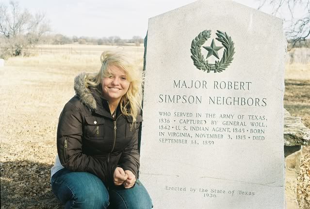
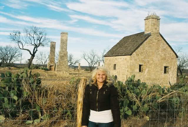
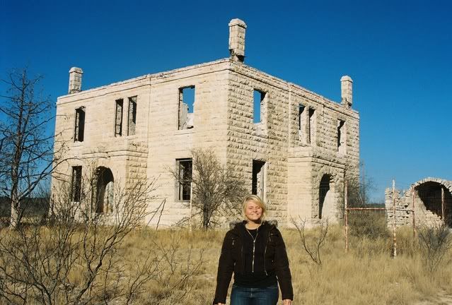
Ask about access to and look for the Old Stone Ranch House, not really a Butterfield location, but an unbelievable restored mid 1850's ranch house in the middle of Lambshead. Not too far from there, and tougher to get access to (its across the river on somebody else's land) is the site of Camp Cooper. The Stone Ranch house is way cooler than any of the other spots around here and access to the inside of the house will be one of the highlights of your trip if you can find somebody let you in. Camp Cooper is a plowed field and Clear Fork Station is I don't think much better, maybe a foundation or chimney rock or two.
http://www.tshaonline.org/handbook/online/articles/OO/apo3.html

but before you get to Albany,
run by Fort Richardson, it was post Butterfield in time period, but it is a really neat Fort with some very well restored quarters and Hospital - State Park with minimal fee

Between Ft Richardson and Belknap about 8 miles north of Graham is the site of the Warren Wagon Train massacre and Brit Johnson's last stand.
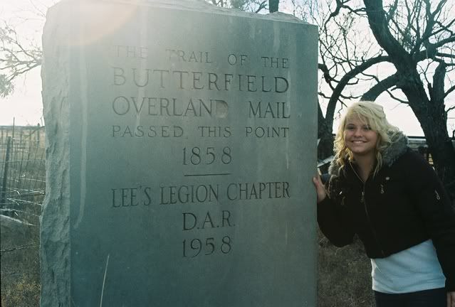
Both on the old Military road which followed the original Butterfield
Warren -
http://www.tshaonline.org/handbook/online/articles/WW/btw3.html
Brit
http://www.tshaonline.org/handbook/online/articles/JJ/fjo7.html
both locations are on the Salt Creek Prairie
"the most dangerous prairie in Texas"
http://www.tshaonline.org/handbook/online/articles/SS/ryseu.html

Fort Belknap is really disappointing for most visitors, its been converted into a community center and looks very unlike its Fort ancestry...

but across the highway from Fort Belknap, down what looks like a turnrow in a grove of trees is the site of the old Fort Belknap cemetery
that makes it worth the stop - not really well marked, but see if you can find that location

Fort Griffin wasn't there during Butterfield, but it too is worth a quick stop - checkout the flats on the river just northeast of the fort, you'll actually cross the river on the highway and see the flats on your right before you get to the Fort (assuming you're coming from the northeast end of the trail going west)Ft Griffin was a pretty rough part of old west history.

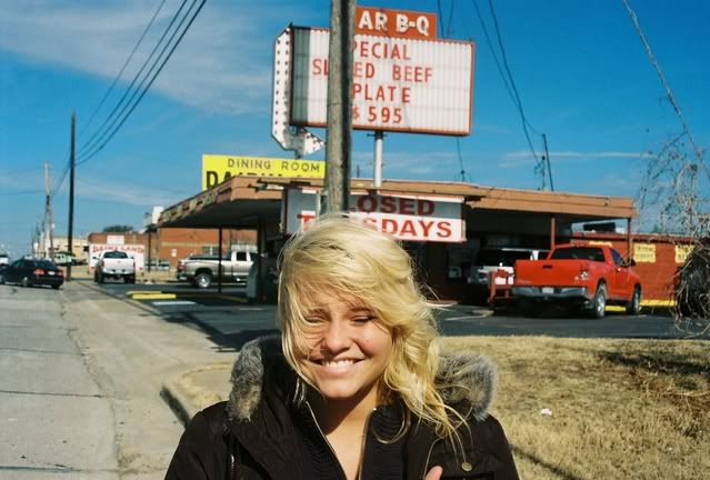
after Lambshead see if you can time it to schedule a meal in Albany...lunch is okay, but supper is better at the Beehive and Albany Mercantile

the route to Fort Phantom crosses a bunch of private ranch land thats now covered with wind turbines, but 180 west to FM600 will bring you down to Ft Phantom from the north. Fort Phantom was there during the Butterfield. There are now a couple of restored buildings and lots of foundations, but it is the iconic lonesome chimneys that make it worth at least a drive by.

quick advertisement here for Frontier Texas! in downtown Abilene - tells an excellent version of the Brit Johnson story and the Elm Creek raid story in a really fancy multi-media presentation -

there's a couple of hiway makers, one north of Abilene and one west at about Tye on I-20, but all they say is Butterfield passed nearby.

before you leave Fort Phantom, if you can find a view point to see west, look west and south, I think you can see the old Pride oil refinery, about 2 miles south of that is where the trail crosses hiway 83/277. It then trends southwest to Castle Peak which looks a little like a tit or nipple on the end of one of the legs of the divide. This is one of the few places open enough in this area to actually see the ground for quite a distance between where you are and where the trail goes of into the distance

next quick stop would be around Castle Peak south of Merkel up Mountain Pass - there was a stage station in the pass, the pass and station drew a bit of attention from the local wild indians. Of course the dirt road up the pass now is not as steep and narrow, and it really only rises 150 feet or so, but it was quite the obstacle back in the day....later travel went up I think its called Owl Gap which is about 5 miles east following roughly the route of Hiway 277

Along this escarpment or caprock looking land feature called the Callahan Divide is supposedly the eastern end of the Coronado's trip before he turned north to Kansas - whether thats true or not, I don't know, but they say the journals and diaries talk of wild grapes found along a landscape feature like the divide, and along in here is one of the only places this far west where that occurred. Back in the 40's Abilene had a billboard on the highway that said something like "15 miles west of this location, Coronado had intercourse with the Indians"

From Mountain Pass you run down to Fort Chadbourne, some of the dirt roads do a pretty good job of following down through Happy Valley and then on to the Fort Chadbourne ranch.

WHATEVER YOU DO, MAKE SURE YOU STOP AT CHADBOURNE.
in fact, call Garland Richards and see if they will be there. He owns the joint, fort and ranch.
http://www.fortchadbourne.com/
If you can get him to show you some of his artifact collection found at the Fort, this will be the highlight of your trip, screw that rock house. Check out the Fountain House graffiti and the newly restored double officer's quarters. They are in the process of restoring the Butterfield station house that was located behind one of the Barracks buildings. (Congratulate them on their million dollar bequest they recently received) Even if you don't get them on the phone, drive through the grounds on your way to San Angelo/Grape Creek and beyond.

That's my section of the trail

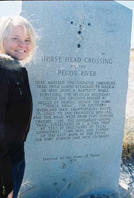
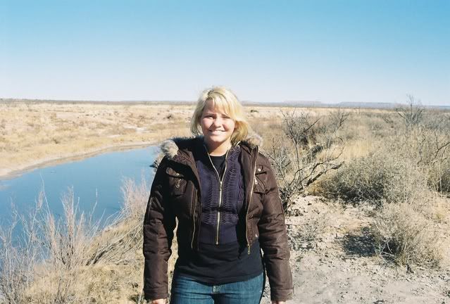
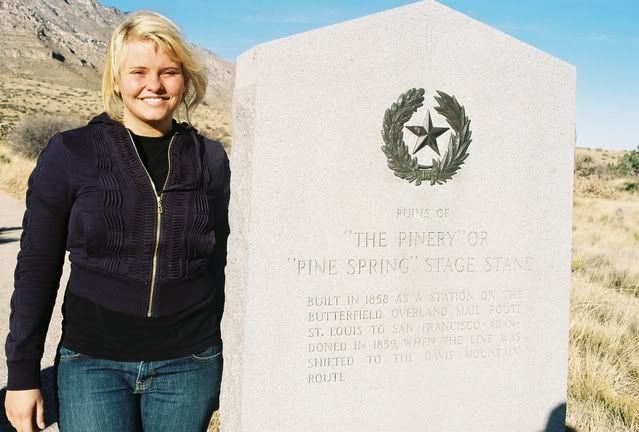
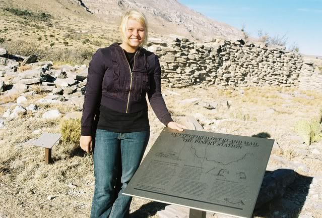
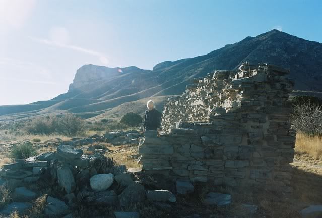
I want to find horsehead crossing on the Pecos sometime. Never been to that. We did the route over to Guadalupe peak and Pine something station there at the Mountain. Pine Springs. and then onto El Paso. Some other time or extend it if you can, run over to old Mesilla at Las Cruces and eat at La Posta on the square, not that good of food, but the actual building was a stage stop on the Butterfield. and as others said above a few more miles west and the dirt road trip up over Apache Pass was pretty cool too.

that is my expert Butterfield guide tour book
print it out
call me if you get lost


TheSheik
How long do you want to ignore this user?
fossil_ag had an old post about Camp Cooper and I added to it with some google links and info on the Old Stone Ranch house

page 13 - about 1/3 the way down the page and then a few more post down from there

SigChiDad
How long do you want to ignore this user?
Sheik, thank you very much. Sounds like you might be an Abilene boy, as was Greene.I did just print it out, and showed it to my wife to prove that I'm not the only one!

[This message has been edited by me1og (edited 1/8/2009 9:39p).]
SigChiDad
How long do you want to ignore this user?
quote:
Is Greene's book on the trail any good?


Very good read...lot's of background of the nature of Sheik's post.He also includes all of Ormsby's first hand account as the first westbound through passenger that pertain to Texas.
NormanAg
How long do you want to ignore this user?
quote:
quick advertisement here for Frontier Texas! in downtown Abilene


Do you have any relatives in the Oklahoma City area? If so, he is a very good friend of mine and a redass aggie to boot.
NormanAg
How long do you want to ignore this user?
My wife is a relative, a few times removed, of Mr Butterfield.
TheSheik
How long do you want to ignore this user?
last name Polk ?

none that I know of
I was the first Ag in my family on that side


I really am a history geek

I forgot that last year sometime I did a google map with pins for as many of the spots I could pull from Greene's book and on up into Missouri - did you know that the first leg of the Butterfield out of St Louis was a train ride to Booneville ?? -

see if this link pulls up a google map with pinpoints - not exact and I'm sure many stations and points are missing, but I captured most along this part of the world

got tired and ran out of Greene's book when I got to El Paso

so if you can find wireless connections in south Throckmorton county....you can google and use the map for directions

while I'm at it, I'll go add Camp Cooper and Stone HOuse pins
NormanAg
How long do you want to ignore this user?
My OKC friend's sister runs the museum in Abilene that you mentioned and she is an Aggie. Thought you might be her husband.

My wife's maternal grandmother was a Butterfield and was a shirt tail relative of the famous civil war Gen Butterfield.

TheSheik
How long do you want to ignore this user?
your OKC friend's sister's married name would be Wetteman maybe .....

much younger than me, she and her Okie State / A&M husband are in Colorado Springs at the AF Academy now I believe, where he teaches...history


NormanAg
How long do you want to ignore this user?
Thanks - my buddy retired two years ago and haven't seen him much since then. Next time I run into him, I'll ask about this.

BTW - when I grew up in the 50's and 60's, my family visited Abilene several time a year to visit my mom's relatives. When my dad retired from the AF in 1973 (in Ft Worth at the time), he moved the family (my mom and sister - I was long gone by then) to Abilene and my sister graduated from Abilene High.

My mom was born in Snyder, but grew up in San Angelo - another place I spent a lot of time in growing up.

SigChiDad
How long do you want to ignore this user?
The trip was very satisfying. We didn't get to see every spot or travel every road I wanted to, but it was every bit the experience I had hoped for.

The first spot we wanted to see was the site of Colbert's Station on the North Shore of the Red River. There was a really cool old road down to the site of the station and ferry...but sitting on the spot were a couple of the scariest looking habitations I've ever seen. I wasn't at all interested in arousing the residents at 7:30 Saturday morning. So, we headed back down to Sherman.

This photo shows the location of the mail station on the southeast corner of the Grayson County Courthouse Square

Following the path of the mail road out of Sherman, you find this cool marker in front of the Chamber of Commerce:

Fifteen miles west on the west side of Whitesboro is Diamond's Station. The station keeper and his brother apparently played prominent roles in the Great Gainesville Hanging of suspected unionists in October of 1862.

This is the site of the station on the northeast side of the Cooke County Courthouse in Gainesville:

This is the location of Dr. Donaldson's station, on the west side of FM 373, about 9 miles straight south of Muenster in southwest Cooke County.


This is the site of Connelly's Station on the north side of Denton Creek, straight south of Forestburg, just inside Wise county

Below is the location of Earhart's station on the west bank of Elm Creek, north of FM 1810 just inside the Jack County line. Greene appears to have misidentified Elm Creek as Big Sandy, which is 10 miles east of the Jack County line in Wise County.

The picture below is a spot that Greene recommended visiting. It's a bridge over the West Fork of The Trinity above Lake Bridgeport on Coca Cola Ranch Road. The gravel road follows about two miles of the old mail road, and Greene says the actual spot they forded can be seen about 30 yards downstream from the bridge.

The site of the Jacksboro Butterfield station is on the south side of downtown, just north of Lost Creek, where now sits a pretty good barbecue joint, oddly named "Dairy Land", pictured below behind Peyton:


This is me with Greene's book and the marker for the station in Jacksboro.


Below,an interesting marker placed by the Young County Historical Society on the north side of Monument Road just inside Young County, about 6 miles northwest of Bryson.


This is the marker for the west exit of the military road from Fort Belknap that the Butterfield Satge used to head out across the Brazos to Franz Station north of Woodson in Throckmorton County.


A stop A.C. Greene and TheSheik recommended was the Fort Belknap cemetery, about 1/2 mile east of the post. Below is Major Robert Neighbor's monument in the cemetery. It is believed he was murdered for trying to be too nice to the Comanches.


The monument at Bud Matthews, where the Overland Mail Trail crossed Hwy. 180, 10 miles west of Albany.


Fort Phantom Hill Guardhouse, used as the station house by the Overland Mail Company.


Looking down Mountain Pass in southwest Taylor County toward the Mountain Pass Station site.


We got to Fort Chadbourne too late for the film I had, so all I can share is a photo of the inside of the south wall of the post's hospital. Greene points out that they brought up good German masons from central Texas to build the camp, instead of having the soldiers do it themselves. Notice the niches in the wall.


[This message has been edited by me1og (edited 1/16/2009 8:03p).]
NormanAg
How long do you want to ignore this user?
Terrific pictures. That was a great idea you and your lovely daughter had and I'm sure it was lots of fun.
WestTxAg06
How long do you want to ignore this user?
Great pictures, me1og. If your daughter is any sort of lover of Texas history, she certainly must have had a blast.

I ate at the Dairyland a couple of times back in high school when I was in Jacksboro for FFA competitions, pretty decent food. I had no idea I was eating barbecue and discussing Range & Pasture Judging on the site of an old Butterfield station.

I have driven past Fort Phantom Hill literally hundreds of times, going between Stamford and Abilene. While I often ruminate what life must have been like in 19th century Jones County, I've only stopped to visit the ruins once, as a kid. One of these days I'm going to have to make the fort a destination, instead of just something to look at while passing by at 70 mph.
SigChiDad
How long do you want to ignore this user?
We spent the night in San Angelo, then headed west on the Arden road, FM 853 to the site of Concho Station. The station was on the opposite bank of Big Rocky creek,just before it enters The Middle Fork of The Concho. Picured below is the bank where the stagecoaches crossed to the station.Greene declared this spot to be "...one of the superbly lovely places on the entire Texas run" of the Butterfield Trail.


The truck...with way too many Aggie stickers...is sitting on Irion County road 412, which follows the old mail road on the north side of The Middle Concho to State Highway 163, where you have to head south.The mail road continued on the north side of the Middle Concho to an area where Centralia Draw, North Mustang Draw,and East Snow Draw all join in a place known as The Head of The Concho, site of the Butterfield Station. It was the last reliable water before Horsehead Crossing on the Pecos. Charles Goodnight would allow his cattle to graze and water there for a couple of days before heading out at sundown across 75 miles of the waterless "dreaded Llano Estacado". To the left of the truck in the photo is the site of Camp Johnston, which was replaced by Fort Chadbourne. The Overland Mail Company moved Concho Sation to the old Army camp after only a few months of operation.


After Head of the Concho Station, the mail road followed Centralia Draw past the ghost town of Stiles, the old county seat of Reagan County.The photo below is looking east down the Butterfield Trail from Stiles.


When Greene visited Stiles in '91, he reported that the old courthouse was in good shape, with just one or two broken windows. Just 17 years later, and it's about to completely collapse. No earthquakes, or fires... perhaps some wind. Man...how do any ancient buildings survive? The mail road continued west up the draw into Upton County on to what Ormsby and Greene call the Llano Estacado. Do people this far south call it the Llano Estacado?
Here's the old Stiles courthouse as of 1/11/09:


Below is a photo looking east toward the site of Llano Estacado Station. Google earth later confirmed that we were only about 100 yards from the station, but on the ground there were no obvious landmarks.Behind me where I was taking the photo, is an enormous natural gas compressor plant yard. From there, we proceeded to Castle Gap, about one mile east of the border with Crane County, 6 miles southeast of the city of Crane.


The photo below is the east side of Castle Gap. It was the path down from the high plane to the Pecos and Horsehead Crossing. RIP Ford and Robert Neighbors(grave marker at Belknap above) shared a mule with a comanche at Castle Gap when they were near starvation. Ford said it was nearly as palatable as beef.


Here's the shot-gunned marker at Horsehead Crossing.The other side was spray painted with green graffiti.


Looking east over the Pecos at Horsehead Crossing. Castle Gap is visible along the horizon to the right of Peyton's head.Charles Goodnight's cattle would reach the opposite bank after 75 miles and two days without water. Often the cattle would drink too much too quickly and kill themselves.Hyponatremia I guess? Goodnight called Horsehead Crossing the graveyard of many a cattleman's dreams.


We headed up the west bank of the Pecos, unlike the Mail Road, which stayed on the east bank almost all the way to New Mexico. We waved toward the Station at Emigrant Crossing, roughly the spot where FM 1776 crosses the Pecos. We turned due west at Orla on state highway 652, crossing the Delaware River a few miles downstream from the location of Delaware Springs Station. It was at Delaware Springs that Ormsby was amused by the fact that their meals were cooked on a fire fueled by buffalo chips. We hit U.S. 180 at the New Mexico line, then headed southwest to Guadalupe Mountains National Park and The Pinery Station. The display at the National Park was really nice, especially after seeing Horsehead Crossing's shot-gunned and spray painted marker. The ruins are really cool.


And with El Capitan in the background...


O.K., I scratched that itch. My kind of road trip.


[This message has been edited by me1og (edited 1/16/2009 8:15p).]
CanyonAg77
How long do you want to ignore this user?
Lovely young lady, and very gracious of her to smile for dad's camera time after time. My kids usually react to dad and his camera with mucho eye rolling...but they end up smiling anyway.

Great trip, very nice pictures. Thanks for sharing. It will be a great memory for both of you.

I'm a history/military/aviation/old car buff, my wife is a geophysicist and I'm a farmer. Our poor kids probably thought every trip was just another classroom session. Everywhere we went, they got to hear about the history and geology, have crops and cars pointed out, as well as every passing aircraft and airport we passed. They have been to more museums, state parks, historical sites, forts and airports than most kids have been to McDonalds. Dad's love of taking crappy back roads in lieu of interstates is a running gag.

I loved it all, and I think they did, too.
CanyonAg77
How long do you want to ignore this user?
quote:
When Greene visited Stiles in '91, he reported that the old courthouse was in good shape, with just one or two broken windows. Just 17 years later, and it's about to completely collapse. No earthquakes, or fires... perhaps some wind. Man...how do any ancient buildings survive?

Arson fire, Christmas eve, 1999. Same idiot torched several other buildings in the area.

I suspect the soot has been blown/washed away in the years since is why you didn't think it was a fire.
SigChiDad
How long do you want to ignore this user?
quote:
Lovely young lady, and very gracious of her to smile for dad's camera time after time. My kids usually react to dad and his camera with mucho eye rolling...but they end up smiling anyway.

She really was a good sport and claimed to genuinely enjoy getting to see a lot of Texas she had never seen before. She definitely thinks I am an uber goober about history.

I have developed the habit of almost never taking a photo of scenery without a person in it, due to my own experience of being bored by a lot of those type of pics...but I realized that in my attempt to give a pictorial tour of the Butterfield Trail across Texas, I really over-exposed Peyton.


[This message has been edited by me1og (edited 1/14/2009 11:24a).]
CanyonAg77
How long do you want to ignore this user?
quote:
I have developed the habit of almost never taking a photo of scenery without a person in it

Good habit. There are tons of photos out there of scenic vistas, historical sites, etc.

But think how pleased your grand kids are going to be when they see pictures of mom as a little girl.

I even have taken pictures of boring stuff such as our cars and farm machinery. In looking at my folks' pictures, I often wish they had better shots of that old "G" John Deere or '55 Chevy fresh from the showroom floor.

I think my kids/grand kids to be might feel the same.


EDIT: And when were you a BQ?

[This message has been edited by CanyonAg77 (edited 1/14/2009 11:51a).]
SigChiDad
How long do you want to ignore this user?
quote:
And when were you a BQ?

Nope. My oldest son is a junior in A-batt.
CanyonAg77
How long do you want to ignore this user?
Ahh, just saw the TABA sticker. I was in White Band, then B-CO INF my senior year when we split into 4 outfits. My son is in C-2 '09...daughter is in Squadron 19.......at USAFA (2011).

[This message has been edited by CanyonAg77 (edited 1/14/2009 7:10p).]
airplane driver
How long do you want to ignore this user?
AirplaneDriver Jr A Batt '06. Great post and pics. An Aside - Jr is trying to get admitted into Norwich for a master's in Military History.
SigChiDad
How long do you want to ignore this user?


[This message has been edited by me1og (edited 1/17/2009 5:29p).]
Refresh
Page 1 of 1
 
×
subscribe Verify your student status
See Subscription Benefits
Trial only available to users who have never subscribed or participated in a previous trial.