
Before the US entered WWII the US was at work planning for ways to support our Allies in Europe in their efforts to repel the German invaders. As France, Belgium, Denmark, Norway, Sweden, and the Netherlands fell, leaving England alone in Western Europe to face the threat of the German forces.
FDR and his War Department began their moves in early 1940. When Churchill asked FDR for naval vessels, FDR agreed to send a fleet of destroyers in exchange for basing rights in eight British possessions in the vicinity of the Atlantic. After Denmark fell, FDR offered to defend Greenland in exchange for basing rights. England took the initiative and occupied Iceland to defend against Germany getting a grip on that strategic island, and later turning over Reykavik and Keflavik to the US.
In late 1940 the US, primarily the Corps of Engineers, began building airstrips and support facilities to conduct large scale movement of warplanes to England. The construction was well underway in early 1941 and ready to support Operation Bolero when it was ordered to begin in early 1942, less than six months after the US declared war.Bolero was the code name for ferry flights of fighters and bombers to Europe along the planned North Atlantic route.
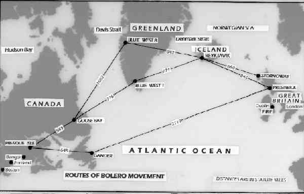
In preliminary planning, the northern routes selected were as near as possible to be the shortest distance to the British Isles and could be broken into flight segments that would accomodate the fuel range of many types of aircraft. Two routes were planned over Greenland to give an alternate if weather on the first choice was bad. Aircraft types that did not have the service range to fit the dimensions of the route would be carried aboard surface ships.
Aircraft that had the range to be moved by ferry flight were: B-17 3400 nmi; B-26 1200 nmi; B-24 2100 nmi; B-25 1350 nmi; P-38 2260 nmi; P-51 950 nmi; P-61 3000 nmi. The range on some aircraft could be increased by adding fuel tanks.
Mileage on the map above is in statute miles. To convert statute miles on the map to nautical miles multiply by 1.2.
The first thing to consider when contemplating a flight along any route in the North Atlantic is that enroute and terminal weather is unpredictable and generally bad. This is compounded by the fact that long range cruise for fuel conservation mandated flying at a lower altitude where clouds were a constant factor. This in turn compounded the problem of navigation when over water and over desolate terrain. Aircraft of that period had the barest choices of navigation aids ... all relying on seeing the ground or the stars to work. (I have spent many hours along in that part of the world waiting and hoping for a break in the clouds, with a bare bones navigation console, to verify my position was where by dead reckoning I thought it was.)
B-17s could traverse all three routes although the ddirect course from Gander to Scotland was dicey. All other aircraft took the routes through Greenland. The primary landing bases in Greenland were Bluie West 1 (at Narsararaq) and Bluie West 8 (at Sondrestromfjord). Bluie was a British code name for Greenland. An emergency airfield Bluie East 1 was located on the east coast of Greenland.
Bombers could make the flights in singles because they were considered to have superior navigation capability (that is a stretch.) Fighter aircraft usually were ferried in groups lead by a bomber aircraft.
All told in 1942, 920 aircraft attempted the North Atlantic crossings shown above. Of these, 882 made it safely to the destination in Scotland. Air ferry peaked in 1944 with 5,900 successfully crossing the North Atlantic. Of the thirty eight aircraft that were lost in 1942 in this operation, some were at sea, some were in ground accidents, some were weathered out of a landing field and unable to get to an alternate field before fuel ran out. Many aircrewmen were lost with the aircraft but many were rescued by naval vessels at sea, by dog sled teams on the Greenland ice cap and other means.
The P-38 recovered from 100 feet of Greenland ice a few years ago was part of that legend. I am sure searches were made for missing aircraft, but doubtless were never found ... and 65 years later await the arrival of a searcher.
[This message has been edited by fossil_ag (edited 11/15/2007 5:23p).]
FDR and his War Department began their moves in early 1940. When Churchill asked FDR for naval vessels, FDR agreed to send a fleet of destroyers in exchange for basing rights in eight British possessions in the vicinity of the Atlantic. After Denmark fell, FDR offered to defend Greenland in exchange for basing rights. England took the initiative and occupied Iceland to defend against Germany getting a grip on that strategic island, and later turning over Reykavik and Keflavik to the US.
In late 1940 the US, primarily the Corps of Engineers, began building airstrips and support facilities to conduct large scale movement of warplanes to England. The construction was well underway in early 1941 and ready to support Operation Bolero when it was ordered to begin in early 1942, less than six months after the US declared war.Bolero was the code name for ferry flights of fighters and bombers to Europe along the planned North Atlantic route.
In preliminary planning, the northern routes selected were as near as possible to be the shortest distance to the British Isles and could be broken into flight segments that would accomodate the fuel range of many types of aircraft. Two routes were planned over Greenland to give an alternate if weather on the first choice was bad. Aircraft types that did not have the service range to fit the dimensions of the route would be carried aboard surface ships.
Aircraft that had the range to be moved by ferry flight were: B-17 3400 nmi; B-26 1200 nmi; B-24 2100 nmi; B-25 1350 nmi; P-38 2260 nmi; P-51 950 nmi; P-61 3000 nmi. The range on some aircraft could be increased by adding fuel tanks.
Mileage on the map above is in statute miles. To convert statute miles on the map to nautical miles multiply by 1.2.
The first thing to consider when contemplating a flight along any route in the North Atlantic is that enroute and terminal weather is unpredictable and generally bad. This is compounded by the fact that long range cruise for fuel conservation mandated flying at a lower altitude where clouds were a constant factor. This in turn compounded the problem of navigation when over water and over desolate terrain. Aircraft of that period had the barest choices of navigation aids ... all relying on seeing the ground or the stars to work. (I have spent many hours along in that part of the world waiting and hoping for a break in the clouds, with a bare bones navigation console, to verify my position was where by dead reckoning I thought it was.)
B-17s could traverse all three routes although the ddirect course from Gander to Scotland was dicey. All other aircraft took the routes through Greenland. The primary landing bases in Greenland were Bluie West 1 (at Narsararaq) and Bluie West 8 (at Sondrestromfjord). Bluie was a British code name for Greenland. An emergency airfield Bluie East 1 was located on the east coast of Greenland.
Bombers could make the flights in singles because they were considered to have superior navigation capability (that is a stretch.) Fighter aircraft usually were ferried in groups lead by a bomber aircraft.
All told in 1942, 920 aircraft attempted the North Atlantic crossings shown above. Of these, 882 made it safely to the destination in Scotland. Air ferry peaked in 1944 with 5,900 successfully crossing the North Atlantic. Of the thirty eight aircraft that were lost in 1942 in this operation, some were at sea, some were in ground accidents, some were weathered out of a landing field and unable to get to an alternate field before fuel ran out. Many aircrewmen were lost with the aircraft but many were rescued by naval vessels at sea, by dog sled teams on the Greenland ice cap and other means.
The P-38 recovered from 100 feet of Greenland ice a few years ago was part of that legend. I am sure searches were made for missing aircraft, but doubtless were never found ... and 65 years later await the arrival of a searcher.
[This message has been edited by fossil_ag (edited 11/15/2007 5:23p).]